
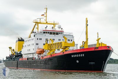
NORDSEE
Trailing Suction Hopper Dredger
Current Trip
DEWVN
| Time Travelled | 3 h, 40 mins |
|---|---|
| Remaining Time | --- |
| Distance Travelled | 28.25 nm |
| Remaining Distance | --- |
| AVG Speed | 9.5 Knots |
| MAX Speed | 12.8 Knots |
| AVG Wind | 12 knots |
| MAX Wind | 13.2 knots |
| MIN Temp | 6.5°C / 43.7°F |
| MAX Temp | 7.6°C / 45.68°F |
| Draught | 7.5 m |
| Position Received | Now |
Current Position
| Longitude | 8.17295° |
|---|---|
| Latitude | 53.57075° |
| Status | Under way using engine |
| Speed | 1.9 Knots |
| Course | 175° |
| Area | North Sea |
| Station | T-AIS |
| Position Received | Now |
Info
Information
The current position of NORDSEE is in North Sea with coordinates 53.57075° / 8.17295° as reported on 2024-04-24 18:17 by AIS to our vessel tracker app. The vessel's current speed is 1.9 Knots
The vessel NORDSEE (IMO: 7504108, MMSI: 211224140) is a Trailing Suction Hopper Dredger that was built in 1978 ( 46 years old ). It's sailing under the flag of [DE] Germany.
In this page you can find informations about the vessels current position, last detected port calls, and current voyage information. If the vessels is not in coverage by AIS you will find the latest position.
The current position of NORDSEE is detected by our AIS receivers and we are not responsible for the reliability of the data. The last position was recorded while the vessel was in Coverage by the Ais receivers of our vessel tracking app.
The current draught of NORDSEE as reported by AIS is 7.5 meters
Weather
| Temperature | 7.2°C / 44.96°F |
|---|---|
| Wind Speed | 11 knots |
| Direction | 5° N |
| Pressure | 1004 hPa |
| Humidity | 62.8 % |
| Cloud Coverage | 72 % |
Featured Company
Last Port Calls
| Port | Arrival | Departure | Time In Port |
|---|---|---|---|
| 2024-04-24 13:16 | 2024-04-24 14:37 | 1 h | |
| 2024-04-24 09:23 | 2024-04-24 10:48 | 1 h | |
| 2024-04-24 05:18 | 2024-04-24 06:38 | 1 h | |
| 2024-04-24 01:20 | 2024-04-24 02:48 | 1 h | |
| 2024-04-23 21:21 | 2024-04-23 22:51 | 1 h | |
| 2024-04-23 17:07 | 2024-04-23 18:26 | 1 h | |
| 2024-04-22 16:02 | 2024-04-23 11:21 | 19 h | |
| 2024-04-22 09:58 | 2024-04-22 10:31 | 32 m | |
| 2024-04-22 04:29 | 2024-04-22 05:34 | 1 h | |
| 2024-04-21 10:37 | 2024-04-21 11:10 | 33 m |
Most Visited Ports (Last year)
| Port | Arrivals | |
|---|---|---|
| 437 | ||
| 2 |
Last Trips
| Origin | Departure | Destination | Arrival | Distance | |
|---|---|---|---|---|---|
| 2024-04-24 12:48 | 2024-04-24 15:16 | 24.92 nm | |||
| 2024-04-24 08:38 | 2024-04-24 11:23 | 25.65 nm | |||
| 2024-04-24 04:48 | 2024-04-24 07:18 | 24.30 nm | |||
| 2024-04-24 00:51 | 2024-04-24 03:20 | 24.68 nm | |||
| 2024-04-23 20:26 | 2024-04-23 23:21 | 26.16 nm | |||
| 2024-04-23 13:21 | 2024-04-23 19:07 | 48.75 nm | |||
| 2024-04-22 12:31 | 2024-04-22 18:02 | 48.69 nm | |||
| 2024-04-22 07:34 | 2024-04-22 11:58 | 49.70 nm | |||
| 2024-04-21 13:10 | 2024-04-22 06:29 | 42.86 nm | |||
| 2024-04-20 18:16 | 2024-04-21 12:37 | 53.03 nm |
Events
| Time | Event | Details | Position / Dest | Info |
|---|---|---|---|---|
| 2024-04-24 17:19 | START Moving | 3.49 nm, East of HOOKSIEL |
53.61439 / 8.15578
DEWVN
|
Speed: 9.7 kn Course: 167.8° |
| 2024-04-24 17:19 | STOP Moving | 3.41 nm, East of HOOKSIEL |
53.61664 / 8.15479
DEWVN
|
Speed: Course: 0° |
| 2024-04-24 16:11 | START Moving | 5.49 nm, North of WANGERSIEL |
53.77376 / 8.04863
DEWVN
|
Speed: 8.8 kn Course: 163.5° |
| 2024-04-24 16:11 | STOP Moving | 5.6 nm, North of WANGERSIEL |
53.77568 / 8.04766
DEWVN
|
Speed: Course: 0° |
| 2024-04-24 15:12 | START Moving | 2.6 nm, North East of HOOKSIEL |
53.67487 / 8.09528
DEWVN
|
Speed: 12.5 kn Course: 327.7° |
| 2024-04-24 15:11 | STOP Moving | 2.47 nm, North East of HOOKSIEL |
53.67144 / 8.09892
DEWVN
|
Speed: Course: 0° |
| 2024-04-24 14:58 | START Moving | 2.62 nm, East of HOOKSIEL |
53.63685 / 8.13826
DEWVN
|
Speed: 10.4 kn Course: 325.5° |
| 2024-04-24 14:57 | STOP Moving | 2.69 nm, East of HOOKSIEL |
53.63520 / 8.14016
DEWVN
|
Speed: Course: 0° |
| 2024-04-24 14:37 | PORT DEPARTURE |
|
53.57250 / 8.17217
DEWVN
|
Speed: 9.4 kn Course: 0° |
| 2024-04-24 14:34 | START Moving |
53.56594 / 8.17067
[DE] WILHELMSHAVEN
|
Speed: 4.8 kn Course: 47° |