
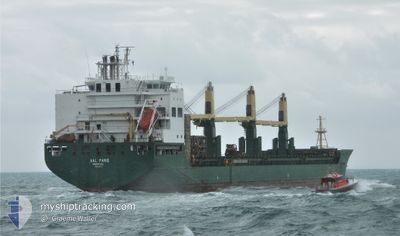
AAL PARIS
General Cargo
Current Trip
| Time Travelled | --- |
|---|---|
| Remaining Time | --- |
| Distance Travelled | 11101.61 nm |
| Remaining Distance | --- |
| AVG Speed | 12.4 Knots |
| MAX Speed | 19.6 Knots |
| AVG Wind | 13.2 knots |
| MAX Wind | 31 knots |
| MIN Temp | 9.2°C / 48.56°F |
| MAX Temp | 28.6°C / 83.48°F |
| Draught | 7.3 m |
| Position Received | 1 d ago |
Current Position
| Longitude | -50.25061° |
|---|---|
| Latitude | 42.73460° |
| Status | Under way using engine |
| Speed | 13.2 Knots |
| Course | 249.7° |
| Area | North Atlantic Ocean |
| Station | T-AIS |
| Position Received | 1 d ago |
Info
Information
The current position of AAL PARIS is in North Atlantic Ocean with coordinates 42.73460° / -50.25061° as reported on 2024-06-15 23:32 by AIS to our vessel tracker app. The vessel's current speed is 13.2 Knots and is heading at the port of HOUSTON. The estimated time of arrival as calculated by vessel tracking app is 2024-06-24 23:00 LT
The vessel AAL PARIS (IMO: 9594494, MMSI: 209451000) is a General Cargo that was built in 2011 ( 13 years old ). It's sailing under the flag of [CY] Cyprus.
In this page you can find informations about the vessels current position, last detected port calls, and current voyage information. If the vessels is not in coverage by AIS you will find the latest position.
The current position of AAL PARIS is detected by our AIS receivers and we are not responsible for the reliability of the data. The last position was recorded while the vessel was in Coverage by the Ais receivers of our vessel tracking app.
The current draught of AAL PARIS as reported by AIS is 7.3 meters
Weather
| Temperature | 18.9°C / 66.02°F |
|---|---|
| Wind Speed | 15 knots |
| Direction | 27° NNE |
| Pressure | 1025 hPa |
| Humidity | 56.1 % |
| Cloud Coverage | 16 % |
Featured Company
Most Visited Ports (Last year)
| Port | Arrivals | |
|---|---|---|
| 2 | ||
| 2 | ||
| 1 | ||
| 1 | ||
| 1 | ||
| 1 |
Events
| Time | Event | Details | Position / Dest | Info |
|---|---|---|---|---|
| 2024-06-15 23:39 | Status Changed | Default Under way using engine |
42.72616 / -50.28175
US HOU
|
Speed: 13.2 kn Course: 249.7° |
| 2024-06-15 23:32 | OUT of Coverage |
42.73460 / -50.25061
North Atlantic Ocean
US HOU
|
Speed: 13.2 kn Course: 249.7° |
|
| 2024-06-15 21:38 | Status Changed | Under way using engine Default |
42.91960 / -49.73244
US HOU
|
Speed: 13.2 kn Course: 228° |
| 2024-06-15 21:35 | Status Changed | Default Under way using engine |
42.92730 / -49.72052
US HOU
|
Speed: 13 kn Course: 228.2° |
| 2024-06-15 21:17 | Status Changed | Under way using engine Default |
42.96968 / -49.65395
US HOU
|
Speed: 13.3 kn Course: 227° |
| 2024-06-15 21:02 | Status Changed | Default Under way using engine |
43.00849 / -49.59749
US HOU
|
Speed: 13.4 kn Course: 226° |
| 2024-06-15 20:38 | ETA Changed | 2024/06/24 23:00 2024/06/24 18:00 |
43.07105 / -49.50803
US HOU
|
Speed: 13.9 kn Course: 226.3° |
| 2024-06-15 19:45 | Detected in Sea | High seas of the North Atlantic Ocean |
43.21277 / -49.31046
North Atlantic Ocean
US HOU
|
Speed: 14 kn Course: 226° |
| 2024-06-15 19:45 | Status Changed | Under way using engine Default |
43.21277 / -49.31046
US HOU
|
Speed: 14 kn Course: 227° |
| 2024-06-15 19:34 | IN Coverage |
43.21277 / -49.31046
North Atlantic Ocean
US HOU
|
Speed: 14 kn Course: 226° |