
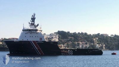
ABEILLE MEDITERRANEE
Anchor Handling Vessel
Current Trip
FRENCH NAVY ORDERS
| Time Travelled | 7 days |
|---|---|
| Remaining Time | --- |
| Distance Travelled | 478.69 nm |
| Remaining Distance | --- |
| AVG Speed | 6.7 Knots |
| MAX Speed | 16 Knots |
| AVG Wind | 7.8 knots |
| MAX Wind | 20 knots |
| MIN Temp | 16°C / 60.8°F |
| MAX Temp | 31.2°C / 88.16°F |
| Draught | 7.5 m |
| Position Received | 2 m ago |
Current Position
| Longitude | 8.75064° |
|---|---|
| Latitude | 41.92838° |
| Status | At anchor |
| Speed | 0.1 Knots |
| Course | 118° |
| Area | Mediterranean Sea - Western Basin |
| Station | T-AIS |
| Position Received | 2 m ago |
Info
Information
The current position of ABEILLE MEDITERRANEE is in Mediterranean Sea - Western Basin with coordinates 41.92838° / 8.75064° as reported on 2024-06-21 20:33 by AIS to our vessel tracker app. The vessel's current speed is 0.1 Knots
The vessel ABEILLE MEDITERRANEE (IMO: 9417749, MMSI: 228416600) is a Anchor Handling Vessel that was built in 2010 ( 14 years old ). It's sailing under the flag of [FR] France.
In this page you can find informations about the vessels current position, last detected port calls, and current voyage information. If the vessels is not in coverage by AIS you will find the latest position.
The current position of ABEILLE MEDITERRANEE is detected by our AIS receivers and we are not responsible for the reliability of the data. The last position was recorded while the vessel was in Coverage by the Ais receivers of our vessel tracking app.
The current draught of ABEILLE MEDITERRANEE as reported by AIS is 7.5 meters
Weather
| Temperature | 18.2°C / 64.76°F |
|---|---|
| Wind Speed | 1 knots |
| Direction | 357° N |
| Pressure | 1018.5 hPa |
| Humidity | 89.1 % |
| Cloud Coverage | --- |
Featured Company
Last Port Calls
| Port | Arrival | Departure | Time In Port |
|---|---|---|---|
| 2024-06-11 06:11 | 2024-06-14 09:16 | 3 d | |
| 2024-06-08 14:57 | 2024-06-10 15:15 | 2 d | |
| 2024-06-07 15:14 | 2024-06-08 09:37 | 18 h | |
| 2024-05-25 06:18 | 2024-06-06 06:41 | 12 d | |
| 2024-05-13 06:54 | 2024-05-18 07:05 | 5 d | |
| 2024-05-10 15:25 | 2024-05-12 08:13 | 1 d | |
| 2024-05-08 14:48 | 2024-05-10 07:15 | 1 d | |
| 2024-05-03 15:38 | 2024-05-07 17:07 | 4 d | |
| 2024-04-26 04:39 | 2024-04-30 12:52 | 4 d | |
| 2024-04-14 06:40 | 2024-04-15 15:16 | 1 d |
Last Trips
| Origin | Departure | Destination | Arrival | Distance | |
|---|---|---|---|---|---|
| 2024-06-10 17:15 | 2024-06-11 08:11 | 106.87 nm | |||
| 2024-06-08 11:37 | 2024-06-08 16:57 | 60.77 nm | |||
| 2024-06-06 08:41 | 2024-06-07 17:14 | 191.43 nm | |||
| 2024-05-18 09:05 | 2024-05-25 08:18 | 634.26 nm | |||
| 2024-05-12 10:13 | 2024-05-13 08:54 | 216.39 nm | |||
| 2024-05-10 09:15 | 2024-05-10 17:25 | 61.19 nm | |||
| 2024-05-07 19:07 | 2024-05-08 16:48 | 152.64 nm | |||
| 2024-04-30 14:52 | 2024-05-03 17:38 | 218.00 nm | |||
| 2024-04-15 17:16 | 2024-04-26 06:39 | 502.83 nm | |||
| 2024-04-13 18:06 | 2024-04-14 08:40 | 142.31 nm |
Events
| Time | Event | Details | Position / Dest | Info |
|---|---|---|---|---|
| 2024-06-21 09:03 | Status Changed | At anchor Default |
41.92967 / 8.75031
FRENCH NAVY ORDERS
|
Speed: Course: 20° |
| 2024-06-21 09:00 | Status Changed | Default At anchor |
41.92967 / 8.75026
FRENCH NAVY ORDERS
|
Speed: Course: 17° |
| 2024-06-20 14:15 | Status Changed | At anchor Under way using engine |
41.92911 / 8.75057
FRENCH NAVY ORDERS
|
Speed: 0.1 kn Course: 61° |
| 2024-06-20 14:07 | STOP Moving | 0.49 nm, North East of AJACCIO |
41.92898 / 8.75084
FRENCH NAVY ORDERS
|
Speed: 0.3 kn Course: 72° |
| 2024-06-20 08:29 | Detected in Sea | French part of the Mediterranean Sea - Western Basin |
41.38103 / 8.97753
Mediterranean Sea - Western Basin
|
Speed: 13.7 kn Course: 294.8° |
| 2024-06-20 08:29 | Status Changed | Under way using engine Default |
41.38103 / 8.97753
FRENCH NAVY ORDERS
|
Speed: 13.4 kn Course: 292° |
| 2024-06-20 08:29 | IN Coverage |
41.38103 / 8.97753
Mediterranean Sea - Western Basin
|
Speed: 13.7 kn Course: 294.8° |
|
| 2024-06-20 06:41 | START Moving | 4.94 nm, North East of BONIFACIO |
41.43499 / 9.24681
FRENCH NAVY ORDERS
|
Speed: 6.6 kn Course: 85° |
| 2024-06-19 18:49 | START Moving | 5.15 nm, North East of BONIFACIO |
41.43624 / 9.25137
FRENCH NAVY ORDERS
|
Speed: 7 kn Course: 74° |
| 2024-06-18 17:37 | STOP Moving | 4.65 nm, North East of BONIFACIO |
41.43641 / 9.23758
FRENCH NAVY ORDERS
|
Speed: 0.1 kn Course: 217° |