
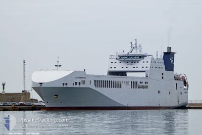
ABU SAMRAH
Cargo
Current Trip
| Time Travelled | 4 days |
|---|---|
| Remaining Time | --- |
| Distance Travelled | 1182.64 nm |
| Remaining Distance | --- |
| AVG Speed | 12.6 Knots |
| MAX Speed | 15.9 Knots |
| AVG Wind | 9.4 knots |
| MAX Wind | 23 knots |
| MIN Temp | 15.2°C / 59.36°F |
| MAX Temp | 25.4°C / 77.72°F |
| Draught | 5.5 m |
| Position Received | 10 h, 34 m ago |
Current Position
| Longitude | 9.63412° |
|---|---|
| Latitude | 37.63208° |
| Status | Under way using engine |
| Speed | 12.1 Knots |
| Course | 270.4° |
| Area | Mediterranean Sea - Western Basin |
| Station | T-AIS |
| Position Received | 10 h, 34 m ago |
Info
Information
The current position of ABU SAMRAH is in Mediterranean Sea - Western Basin with coordinates 37.63208° / 9.63412° as reported on 2024-05-28 19:15 by AIS to our vessel tracker app. The vessel's current speed is 12.1 Knots and is heading at the port of TANGIER. The estimated time of arrival as calculated by vessel tracking app is 2024-05-31 09:00 LT
The vessel ABU SAMRAH (IMO: 9925655, MMSI: 538010634) is a Cargo It's sailing under the flag of [MH] Marshall Is.
In this page you can find informations about the vessels current position, last detected port calls, and current voyage information. If the vessels is not in coverage by AIS you will find the latest position.
The current position of ABU SAMRAH is detected by our AIS receivers and we are not responsible for the reliability of the data. The last position was recorded while the vessel was in Coverage by the Ais receivers of our vessel tracking app.
The current draught of ABU SAMRAH as reported by AIS is 5.5 meters
Weather
| Temperature | 19.7°C / 67.46°F |
|---|---|
| Wind Speed | 7 knots |
| Direction | 319° NW |
| Pressure | 1017.4 hPa |
| Humidity | 69.4 % |
| Cloud Coverage | 18 % |
Featured Company
Last Port Calls
| Port | Arrival | Departure | Time In Port |
|---|---|---|---|
| 2024-05-23 20:49 | 2024-05-24 15:49 | 18 h | |
| 2024-05-17 07:53 | 2024-05-18 11:48 | 1 d | |
| 2024-04-27 10:48 | 2024-04-27 23:30 | 12 h | |
| 2024-04-21 06:44 | 2024-04-21 16:28 | 9 h | |
| 2024-04-19 03:25 | 2024-04-19 10:55 | 7 h | |
| 2024-04-13 03:14 | 2024-04-13 13:18 | 10 h | |
| 2024-04-06 19:48 | 2024-04-07 09:24 | 13 h | |
| 2024-04-05 18:48 | 2024-04-06 15:25 | 20 h | |
| 2024-03-24 15:00 | 2024-03-26 13:26 | 1 d | |
| 2024-03-17 14:10 | 2024-03-18 01:30 | 11 h |
Last Trips
| Origin | Departure | Destination | Arrival | Distance | |
|---|---|---|---|---|---|
| 2024-05-18 13:48 | 2024-05-23 23:49 | 1448.89 nm | |||
| 2024-04-28 02:30 | 2024-05-17 09:53 | 2080.85 nm | |||
| 2024-04-21 18:28 | 2024-04-27 13:48 | 1511.21 nm | |||
| 2024-04-19 12:55 | 2024-04-21 08:44 | 83.09 nm | |||
| 2024-04-13 15:18 | 2024-04-19 05:25 | 380.41 nm | |||
| 2024-04-07 12:24 | 2024-04-13 05:14 | 1541.14 nm | |||
| 2024-04-06 18:25 | 2024-04-06 22:48 | 53.43 nm | |||
| 2024-03-26 14:26 | 2024-04-05 21:48 | 3131.39 nm | |||
| 2024-03-18 04:30 | 2024-03-24 16:00 | 2846.52 nm | |||
| 2024-03-15 04:24 | 2024-03-17 17:10 | 59.13 nm |
Events
| Time | Event | Details | Position / Dest | Info |
|---|---|---|---|---|
| 2024-05-28 19:24 | Status Changed | Default Under way using engine |
37.63167 / 9.59833
TANGIER-MED
|
Speed: 12.1 kn Course: 270.4° |
| 2024-05-28 19:15 | Status Changed | Under way using engine Default |
37.63208 / 9.63412
TANGIER-MED
|
Speed: 12 kn Course: 271° |
| 2024-05-28 19:15 | OUT of Coverage |
37.63208 / 9.63412
Mediterranean Sea - Western Basin
TANGIER-MED
|
Speed: 12.1 kn Course: 270.4° |
|
| 2024-05-28 19:09 | IN Coverage |
37.63208 / 9.63412
Mediterranean Sea - Western Basin
TANGIER-MED
|
Speed: 12.1 kn Course: 270.4° |
|
| 2024-05-28 16:53 | Status Changed | Default Under way using engine |
37.63324 / 10.22831
TANGIER-MED
|
Speed: 12 kn Course: 268.7° |
| 2024-05-28 16:49 | OUT of Coverage |
37.63356 / 10.24375
Mediterranean Sea - Western Basin
TANGIER-MED
|
Speed: 12 kn Course: 268.7° |
|
| 2024-05-28 13:42 | Status Changed | Under way using engine Default |
37.53527 / 11.01270
TANGIER-MED
|
Speed: 12.8 kn Course: 302° |
| 2024-05-28 13:22 | Status Changed | Default Under way using engine |
37.49829 / 11.08612
TANGIER-MED
|
Speed: 12.8 kn Course: 302° |
| 2024-05-28 11:40 | Change Sea Area | Tunisian part of the Mediterranean Sea - Western Basin Tunisian part of the Mediterranean Sea - Eastern Basin |
37.31747 / 11.47998
Mediterranean Sea - Western Basin
TANGIER-MED
|
Speed: 12.6 kn Course: 302° |
| 2024-05-28 09:35 | Change Sea Area | Tunisian part of the Mediterranean Sea - Eastern Basin Italian part of the Mediterranean Sea - Eastern Basin |
37.07965 / 11.97813
Mediterranean Sea - Eastern Basin
TANGIER-MED
|
Speed: 13.8 kn Course: 291.7° |