
ADAM-A
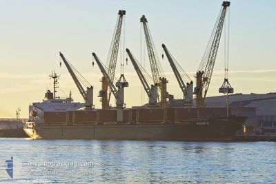
Bulk Carrier
Current Trip
| Time Travelled | 7 days |
|---|---|
| Remaining Time | --- |
| Distance Travelled | 1833.16 nm |
| Remaining Distance | --- |
| AVG Speed | 10.8 Knots |
| MAX Speed | 13 Knots |
| AVG Wind | 11.3 knots |
| MAX Wind | 21.1 knots |
| MIN Temp | 9.9°C / 49.82°F |
| MAX Temp | 22.6°C / 72.68°F |
| Draught | 5.6 m |
| Position Received | 21 m ago |
Current Position
| Longitude | 28.36564° |
|---|---|
| Latitude | 40.71143° |
| Status | Under way sailing |
| Speed | 1.5 Knots |
| Course | 169° |
| Area | Sea of Marmara |
| Station | T-AIS |
| Position Received | 21 m ago |
Info
Information
The current position of ADAM-A is in Sea of Marmara with coordinates 40.71143° / 28.36564° as reported on 2024-05-18 01:43 by AIS to our vessel tracker app. The vessel's current speed is 1.5 Knots and is heading at the port of SULINA. The estimated time of arrival as calculated by vessel tracking app is 2024-05-19 00:00 LT
The vessel ADAM-A (IMO: 9114543, MMSI: 511100696) is a Bulk Carrier that was built in 1995 ( 29 years old ). It's sailing under the flag of [PW] Palau.
In this page you can find informations about the vessels current position, last detected port calls, and current voyage information. If the vessels is not in coverage by AIS you will find the latest position.
The current position of ADAM-A is detected by our AIS receivers and we are not responsible for the reliability of the data. The last position was recorded while the vessel was in Coverage by the Ais receivers of our vessel tracking app.
The current draught of ADAM-A as reported by AIS is 5.6 meters
Weather
| Temperature | 14.8°C / 58.64°F |
|---|---|
| Wind Speed | 11 knots |
| Direction | 47° NE |
| Pressure | 1017.3 hPa |
| Humidity | 80 % |
| Cloud Coverage | --- |
Featured Company
Last Trips
| Origin | Departure | Destination | Arrival | Distance | |
|---|---|---|---|---|---|
| 2024-04-24 10:25 | 2024-05-06 17:28 | 2169.16 nm | |||
| 2024-04-03 14:57 | 2024-04-22 17:46 | 2848.20 nm | |||
| 2024-03-30 17:12 | 2024-04-03 14:20 | 15.40 nm | |||
| 2024-03-10 09:43 | 2024-03-30 16:28 | 2413.95 nm | |||
| 2024-02-21 19:17 | 2024-03-08 17:34 | 2131.69 nm |
Events
| Time | Event | Details | Position / Dest | Info |
|---|---|---|---|---|
| 2024-05-18 01:48 | Status Changed | Default Under way sailing |
40.71209 / 28.36276
RO SUL
|
Speed: 1.5 kn Course: 169° |
| 2024-05-18 01:09 | Status Changed | Under way sailing Default |
40.70227 / 28.38283
RO SUL
|
Speed: 1.6 kn Course: 140° |
| 2024-05-18 00:55 | Status Changed | Default Under way sailing |
40.69800 / 28.38887
RO SUL
|
Speed: 1.6 kn Course: 147° |
| 2024-05-18 00:41 | Status Changed | Under way sailing Default |
40.69402 / 28.39550
RO SUL
|
Speed: 1.5 kn Course: 148° |
| 2024-05-18 00:28 | Status Changed | Default Under way sailing |
40.69073 / 28.40162
RO SUL
|
Speed: 1.4 kn Course: 150° |
| 2024-05-18 00:02 | Status Changed | Under way sailing Default |
40.68539 / 28.41374
RO SUL
|
Speed: 1.3 kn Course: 145° |
| 2024-05-17 23:44 | Status Changed | Default Under way sailing |
40.68275 / 28.42150
RO SUL
|
Speed: 1.2 kn Course: 149° |
| 2024-05-17 22:26 | Status Changed | Under way sailing Default |
40.68049 / 28.45353
RO SUL
|
Speed: 1.1 kn Course: 141° |
| 2024-05-17 22:08 | Status Changed | Default Under way sailing |
40.68145 / 28.46066
RO SUL
|
Speed: 0.9 kn Course: 134° |
| 2024-05-17 22:00 | Status Changed | Under way sailing Default |
40.68212 / 28.46369
RO SUL
|
Speed: 1 kn Course: 134° |