
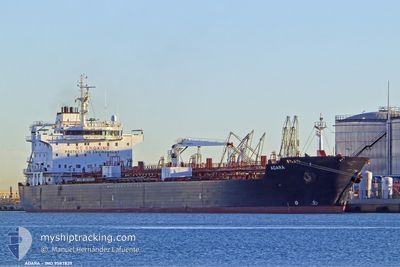
ADARA
Oil/Chemical Tanker
Current Trip
| Time Travelled | 1 day |
|---|---|
| Remaining Time | --- |
| Distance Travelled | 235.98 nm |
| Remaining Distance | 23.55 nm |
| AVG Speed | 10.7 Knots |
| MAX Speed | 14.6 Knots |
| AVG Wind | 15.8 knots |
| MAX Wind | 20.7 knots |
| MIN Temp | 13.4°C / 56.12°F |
| MAX Temp | 16.5°C / 61.7°F |
| Draught | 11 m |
| Position Received | Now |
Current Position
| Longitude | -1.06697° |
|---|---|
| Latitude | 50.61816° |
| Status | At anchor |
| Speed | |
| Course | 232° |
| Area | English Channel |
| Station | T-AIS |
| Position Received | Now |
Info
Information
The current position of ADARA is in English Channel with coordinates 50.61816° / -1.06697° as reported on 2024-06-20 19:36 by AIS to our vessel tracker app. The vessel's current speed is 0 Knots and is heading at the port of FAWLEY. The estimated time of arrival as calculated by vessel tracking app is 2024-06-19 20:00 LT
The vessel ADARA (IMO: 9587829, MMSI: 226044000) is a Oil/Chemical Tanker that was built in 2011 ( 13 years old ). It's sailing under the flag of [FR] France.
In this page you can find informations about the vessels current position, last detected port calls, and current voyage information. If the vessels is not in coverage by AIS you will find the latest position.
The current position of ADARA is detected by our AIS receivers and we are not responsible for the reliability of the data. The last position was recorded while the vessel was in Coverage by the Ais receivers of our vessel tracking app.
The current draught of ADARA as reported by AIS is 11 meters
Weather
| Temperature | 16.2°C / 61.16°F |
|---|---|
| Wind Speed | 3 knots |
| Direction | 72° ENE |
| Pressure | 1017.3 hPa |
| Humidity | 81.8 % |
| Cloud Coverage | 24 % |
Featured Company
Last Port Calls
| Port | Arrival | Departure | Time In Port |
|---|---|---|---|
| 2024-06-17 16:14 | 2024-06-19 01:37 | 1 d | |
| 2024-06-10 17:44 | 2024-06-12 18:42 | 2 d | |
| 2024-05-16 10:50 | 2024-05-17 12:38 | 1 d | |
| 2024-05-02 17:27 | 2024-05-04 12:25 | 1 d | |
| 2024-04-24 15:44 | 2024-04-26 06:28 | 1 d | |
| 2024-04-15 13:34 | 2024-04-17 06:12 | 1 d | |
| 2024-04-05 04:13 | 2024-04-06 12:15 | 1 d |
Most Visited Ports (Last year)
| Port | Arrivals | |
|---|---|---|
| 11 | ||
| 5 | ||
| 3 | ||
| 2 | ||
| 1 | ||
| 1 |
Last Trips
| Origin | Departure | Destination | Arrival | Distance | |
|---|---|---|---|---|---|
| 2024-06-12 20:42 | 2024-06-17 18:14 | 409.36 nm | |||
| 2024-05-17 12:38 | 2024-06-10 19:44 | 6381.42 nm | |||
| 2024-05-04 14:25 | 2024-05-16 10:50 | 2630.33 nm | |||
| 2024-04-26 07:28 | 2024-05-02 19:27 | 1412.12 nm | |||
| 2024-04-17 09:12 | 2024-04-24 16:44 | 2299.07 nm | |||
| 2024-04-06 15:15 | 2024-04-15 16:34 | 937.81 nm | |||
| 2024-03-29 21:50 | 2024-04-05 07:13 | 90.32 nm |
Events
| Time | Event | Details | Position / Dest | Info |
|---|---|---|---|---|
| 2024-06-20 08:48 | Status Changed | At anchor Default |
50.61812 / -1.06818
NLRTM>GBFAW
|
Speed: Course: 212° |
| 2024-06-20 08:45 | Status Changed | Default At anchor |
50.61808 / -1.06810
NLRTM>GBFAW
|
Speed: 0.1 kn Course: 215° |
| 2024-06-19 20:51 | STOP Moving | 3.53 nm, South East of SANDOWN |
50.61945 / -1.07519
NLRTM>GBFAW
|
Speed: 0.3 kn Course: 114° |
| 2024-06-19 20:42 | Status Changed | At anchor Under way using engine |
50.61872 / -1.07380
NLRTM>GBFAW
|
Speed: 0.6 kn Course: 91° |
| 2024-06-19 14:15 | Status Changed | Under way using engine Default |
50.71463 / .75048
NLRTM>GBFAW
|
Speed: 14.5 kn Course: 233° |
| 2024-06-19 14:13 | Status Changed | Default Under way using engine |
50.71928 / .76001
NLRTM>GBFAW
|
Speed: 14.4 kn Course: 231.9° |
| 2024-06-19 14:03 | Status Changed | Under way using engine Default |
50.74560 / .81353
NLRTM>GBFAW
|
Speed: 14.3 kn Course: 232° |
| 2024-06-19 14:00 | Status Changed | Default Under way using engine |
50.75097 / .82439
NLRTM>GBFAW
|
Speed: 14.3 kn Course: 232.9° |
| 2024-06-19 11:40 | Change Sea Area | United Kingdom part of the English Channel United Kingdom part of the North Sea |
51.08031 / 1.46463
English Channel
NLRTM>GBFAW
|
Speed: 12.3 kn Course: 232.5° |
| 2024-06-19 06:43 | Change Sea Area | United Kingdom part of the North Sea Dutch part of the North Sea |
51.86317 / 2.53054
North Sea
NLRTM>GBFAW
|
Speed: 12.8 kn Course: 227.6° |