
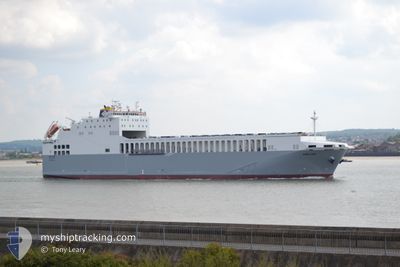
ADELINE
Ro-Ro Cargo
Aktuelle Reise
| Trip Time | 10 h, 13 Minuten |
|---|---|
| Trip Distanz | 141.74 nm |
| Durchschnittliche Geschwindigkeit | 12.4 Knoten |
| Maximale Geschwindigkeit | 18.3 Knoten |
| Tiefgang | 5.4 m |
| Durchschnittliche Windgeschwindigkeit | 6.9 Knoten |
| Maximale Windgeschwindigkeit | 13.5 Knoten |
| Minimale Temperatur | 6.6°C / 43.88°F |
| Maximale Temperatur | 12.3°C / 54.14°F |
| Position erhalten | 1 m alt |
Aktuelle Position
| Länge | --- |
|---|---|
| Breite | --- |
| Zustand | Under way using engine |
| Geschwindigkeit | |
| Kurs | 286° |
| Gebiet | North Sea |
| Station | T-AIS |
| Position erhalten | 1 m alt |
Schiffsdetails
Information
Die ADELINE befindet sich derzeit in North Sea mit den Koordinaten 51.51185° / 0.15273°, Diese Position wurde am 2024-11-18 04:18 von unserer Schiffsverfolgungs-App über AIS erfasst. Das Schiff fährt momentan mit einer Geschwindigkeit von 0 Knoten und liegt im Hafen von DAGENHAM .
Das Schiff ADELINE (IMO: 9539092, MMSI: 256284000) ist Ro-Ro Cargo das wurde im Jahr 2012 ( 12 Jahre alt ) gebaut. und fährt unter der Flagge von [MT] Malta.
Auf dieser Seite erhalten Sie Informationen zur aktuellen Position des Schiffes, zu den letzten bekannten Hafenanläufen und zu den aktuellen Reiseinformationen. Sollte das Schiff nicht durch AIS abgedeckt sein, wird die zuletzt erfasste Position angezeigt.
Die ADELINE wird durch unsere AIS-Empfänger ermittelt. Wir übernehmen keine Gewähr für die Richtigkeit der Daten. Die letzte Position wurde von unseren AIS-Empfängern aufgezeichnet, während das Schiff in Reichweite war.
Der aktuelle Entwurf von ADELINE, wie von AIS gemeldet, betragt 5.4 meter
Wetter
| Temperatur | 7.9°C / 46.22°F |
|---|---|
| Windgeschwindigkeit | 5 Knoten |
| Windrichtung | 286° WNW |
| Luftdruck | 1012.1 hPa |
| Luftfeuchtigkeit | 79.5 % |
| Wolken | 96 % |
Featured Company
Letzte Hafenanläufe
| Hafen | Ankunft | Abfahrt | Time In Port |
|---|---|---|---|
| 2024-11-16 02:26 | |||
| 2024-11-15 08:26 | 2024-11-15 16:13 | 7 h | |
| 2024-11-14 15:05 | 2024-11-14 21:51 | 6 h | |
| 2024-11-13 20:30 | 2024-11-14 04:16 | 7 h | |
| 2024-11-13 03:42 | 2024-11-13 10:07 | 6 h | |
| 2024-11-12 09:30 | 2024-11-12 16:10 | 6 h | |
| 2024-11-11 15:57 | 2024-11-11 21:40 | 5 h | |
| 2024-11-09 08:31 | 2024-11-11 04:08 | 1 d | |
| 2024-11-08 14:33 | 2024-11-08 21:39 | 7 h | |
| 2024-11-07 20:54 | 2024-11-08 04:08 | 7 h |
Meistbesuchte Häfen (Letztes Jahr)
| Hafen | Ankünfte | |
|---|---|---|
| 170 | ||
| 169 |
Letzte Reisen
| Herkunft | Abfahrt | Ziel | Ankunft | Distanz | |
|---|---|---|---|---|---|
| 2024-11-15 17:13 | 2024-11-16 02:26 | 141.74 nm | |||
| 2024-11-14 21:51 | 2024-11-15 09:26 | 143.76 nm | |||
| 2024-11-14 05:16 | 2024-11-14 15:05 | 142.75 nm | |||
| 2024-11-13 10:07 | 2024-11-13 21:30 | 143.56 nm | |||
| 2024-11-12 17:10 | 2024-11-13 03:42 | 144.24 nm | |||
| 2024-11-11 21:40 | 2024-11-12 10:30 | 149.48 nm | |||
| 2024-11-11 05:08 | 2024-11-11 15:57 | 143.81 nm | |||
| 2024-11-08 21:39 | 2024-11-09 09:31 | 143.40 nm | |||
| 2024-11-08 05:08 | 2024-11-08 14:33 | 143.01 nm | |||
| 2024-11-07 09:48 | 2024-11-07 21:54 | 142.64 nm |
Events
| Zeit | Ereignis | Details | Position / Ziel | Information |
|---|---|---|---|---|
| 2024-11-16 02:32 | STOP Bewegung |
51.51149 / .15255
[GB] DAGENHAM
|
Geschwindigkeit: 0.3 kn Kurs: 290° |
|
| 2024-11-16 02:26 | ZIELHAFEN |
|
51.51004 / .15782
[GB] DAGENHAM
|
Geschwindigkeit: 4.9 kn Kurs: 289° |
| 2024-11-16 01:24 | geänderte voraussichtliche Ankunftszeit | 2024/11/16 02:20 2024/11/16 02:40 |
51.44922 / .35230
GBDAG
|
Geschwindigkeit: 10.4 kn Kurs: 270.6° |
| 2024-11-16 00:34 | geänderte voraussichtliche Ankunftszeit | 2024/11/16 02:40 2024/11/16 02:20 |
51.50374 / .56260
GBDAG
|
Geschwindigkeit: 15.4 kn Kurs: 273.4° |
| 2024-11-16 00:28 | geänderte voraussichtliche Ankunftszeit | 2024/11/16 02:20 2024/11/16 03:20 |
51.50274 / .60516
GBDAG
|
Geschwindigkeit: 15.4 kn Kurs: 272.5° |
| 2024-11-15 22:33 | geänderte voraussichtliche Ankunftszeit | 2024/11/16 03:20 2024/11/16 04:00 |
51.48412 / 1.41785
GBDAG
|
Geschwindigkeit: 16 kn Kurs: 259.5° |
| 2024-11-15 20:07 | Ändere Seegebiet | United Kingdom part of the North Sea Belgian part of the North Sea |
51.63287 / 2.26579
North Sea
GBDAG
|
Geschwindigkeit: 13.6 kn Kurs: 278.4° |
| 2024-11-15 17:01 | Ändere Seegebiet | Belgian part of the North Sea Dutch part of the North Sea |
51.40883 / 3.31082
North Sea
GBDAG
|
Geschwindigkeit: 17 kn Kurs: 274.9° |
| 2024-11-15 16:13 | ABFAHRTSHAFEN |
|
51.44682 / 3.67027
GBDAG
|
Geschwindigkeit: 11.3 kn Kurs: 223° |
| 2024-11-15 16:07 | START Bewegung |
51.45972 / 3.68118
[NL] VLISSINGEN
|
Geschwindigkeit: 4.1 kn Kurs: 190° |