
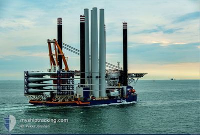
AEOLUS
Offshore Construction Jack Up
Current Trip
| Trip Time | 1 day |
|---|---|
| Trip Distance | 270.98 nm |
| AVG Speed | 9.9 Knots |
| MAX Speed | 12.5 Knots |
| Draught | 8 m |
| AVG Wind | 7.5 knots |
| MAX Wind | 11 knots |
| MIN Temp | 14.9°C / 58.82°F |
| MAX Temp | 18.7°C / 65.66°F |
| Position Received | 3 m ago |
Current Position
| Longitude | -1.46023° |
|---|---|
| Latitude | 54.98518° |
| Status | Moored |
| Speed | |
| Course | 71° |
| Area | North Sea |
| Station | T-AIS |
| Position Received | 3 m ago |
Info
Information
The current position of AEOLUS is in North Sea with coordinates 54.98518° / -1.46023° as reported on 2024-06-28 09:36 by AIS to our vessel tracker app. The vessel's current speed is 0 Knots and is currently inside the port of TYNE.
The vessel AEOLUS (IMO: 9612636, MMSI: 245179000) is a Offshore Construction Jack Up that was built in 2014 ( 10 years old ). It's sailing under the flag of [NL] Netherlands.
In this page you can find informations about the vessels current position, last detected port calls, and current voyage information. If the vessels is not in coverage by AIS you will find the latest position.
The current position of AEOLUS is detected by our AIS receivers and we are not responsible for the reliability of the data. The last position was recorded while the vessel was in Coverage by the Ais receivers of our vessel tracking app.
The current draught of AEOLUS as reported by AIS is 8.4 meters
Weather
| Temperature | 14.9°C / 58.82°F |
|---|---|
| Wind Speed | 15 knots |
| Direction | 261° W |
| Pressure | 1007.4 hPa |
| Humidity | 63.9 % |
| Cloud Coverage | 83 % |
Featured Company
Last Port Calls
| Port | Arrival | Departure | Time In Port |
|---|---|---|---|
| 2024-06-25 20:02 | |||
| 2024-06-24 18:16 | 2024-06-24 19:00 | 44 m | |
| 2024-06-21 11:20 | 2024-06-24 17:18 | 3 d | |
| 2024-06-21 09:47 | 2024-06-21 10:34 | 46 m | |
| 2024-06-07 06:39 | 2024-06-12 20:24 | 5 d | |
| 2024-05-23 19:13 | 2024-05-27 18:22 | 3 d | |
| 2024-05-01 06:34 | 2024-05-08 03:25 | 6 d | |
| 2024-04-30 03:01 | 2024-04-30 04:11 | 1 h | |
| 2024-04-26 01:19 | 2024-04-30 01:56 | 4 d | |
| 2024-04-25 23:51 | 2024-04-26 00:30 | 39 m |
Most Visited Ports (Last year)
| Port | Arrivals | |
|---|---|---|
| 6 | ||
| 4 | ||
| 3 | ||
| 1 |
Last Trips
| Origin | Departure | Destination | Arrival | Distance | |
|---|---|---|---|---|---|
| 2024-06-24 21:00 | 2024-06-25 21:02 | 270.98 nm | |||
| 2024-06-24 19:18 | 2024-06-24 20:16 | 5.12 nm | |||
| 2024-06-21 12:34 | 2024-06-21 13:20 | 5.52 nm | |||
| 2024-06-12 21:24 | 2024-06-21 11:47 | 354.91 nm | |||
| 2024-05-27 19:22 | 2024-06-07 07:39 | 256.43 nm | |||
| 2024-05-08 04:25 | 2024-05-23 20:13 | 247.17 nm | |||
| 2024-04-30 06:11 | 2024-05-01 07:34 | 269.95 nm | |||
| 2024-04-30 03:56 | 2024-04-30 05:01 | 4.71 nm | |||
| 2024-04-26 02:30 | 2024-04-26 03:19 | 5.68 nm | |||
| 2024-04-25 11:45 | 2024-04-26 01:51 | 24.52 nm |
Events
| Time | Event | Details | Position / Dest | Info |
|---|---|---|---|---|
| 2024-06-28 09:22 | Draught Changed | 8.4 8.6 |
54.98519 / -1.46017
[GB] TYNE
|
Speed: Course: 71° |
| 2024-06-27 15:36 | ETA Changed | 2024/06/28 10:00 2024/06/26 01:00 |
54.98521 / -1.46027
[GB] TYNE
|
Speed: Course: 71° |
| 2024-06-27 15:36 | Draught Changed | 8.6 8 |
54.98521 / -1.46027
[GB] TYNE
|
Speed: Course: 71° |
| 2024-06-27 15:36 | Destination Changed | SOFIA OWF TYNE PORT |
54.98521 / -1.46027
[GB] TYNE
|
Speed: Course: 71° |
| 2024-06-25 21:11 | Status Changed | Moored Under way using engine |
54.98518 / -1.46025
[GB] TYNE
|
Speed: Course: 71° |
| 2024-06-25 20:35 | STOP Moving |
54.98584 / -1.46131
[GB] TYNE
|
Speed: 0.2 kn Course: 84° |
|
| 2024-06-25 20:02 | PORT ARRIVAL |
|
55.01263 / -1.40266
[GB] TYNE
|
Speed: 9.9 kn Course: 251° |
| 2024-06-25 16:04 | IN Coverage |
54.73380 / -.35202
North Sea
TYNE PORT
|
Speed: 10.7 kn Course: 297.8° |
|
| 2024-06-25 12:20 | OUT of Coverage |
54.39833 / .78061
North Sea
TYNE PORT
|
Speed: 12.5 kn Course: 298.3° |
|
| 2024-06-25 10:27 | IN Coverage |
54.23098 / 1.34630
North Sea
TYNE PORT
|
Speed: 11.1 kn Course: 295.2° |