
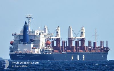
AFRICAN QUAIL
Cargo
Current Trip
AU BEN
| Time Travelled | 4 days |
|---|---|
| Remaining Time | --- |
| Distance Travelled | 64.12 nm |
| Remaining Distance | --- |
| AVG Speed | 11.5 Knots |
| MAX Speed | 13.7 Knots |
| AVG Wind | 12.1 knots |
| MAX Wind | 18 knots |
| MIN Temp | 17.8°C / 64.04°F |
| MAX Temp | 22.9°C / 73.22°F |
| Draught | 8 m |
| Position Received | 5 m ago |
Current Position
| Longitude | 153.25116° |
|---|---|
| Latitude | -26.72402° |
| Status | At anchor |
| Speed | 0.1 Knots |
| Course | 221° |
| Area | Coral Sea |
| Station | T-AIS |
| Position Received | 5 m ago |
Info
Information
The current position of AFRICAN QUAIL is in Coral Sea with coordinates -26.72402° / 153.25116° as reported on 2024-06-01 10:29 by AIS to our vessel tracker app. The vessel's current speed is 0.1 Knots
The vessel AFRICAN QUAIL (IMO: 9738741, MMSI: 311000909) is a Cargo It's sailing under the flag of [BS] Bahamas.
In this page you can find informations about the vessels current position, last detected port calls, and current voyage information. If the vessels is not in coverage by AIS you will find the latest position.
The current position of AFRICAN QUAIL is detected by our AIS receivers and we are not responsible for the reliability of the data. The last position was recorded while the vessel was in Coverage by the Ais receivers of our vessel tracking app.
The current draught of AFRICAN QUAIL as reported by AIS is 8 meters
Weather
| Temperature | 18.2°C / 64.76°F |
|---|---|
| Wind Speed | 17 knots |
| Direction | 236° SW |
| Pressure | 1016.9 hPa |
| Humidity | 85.2 % |
| Cloud Coverage | 100 % |
Featured Company
Last Port Calls
Most Visited Ports (Last year)
| Port | Arrivals | |
|---|---|---|
| 3 | ||
| 2 | ||
| 2 | ||
| 2 | ||
| 1 | ||
| 1 |
Last Trips
| Origin | Departure | Destination | Arrival | Distance | |
|---|---|---|---|---|---|
| 2024-05-22 09:16 | 2024-05-25 06:01 | 704.64 nm | |||
| 2024-04-22 13:36 | 2024-05-18 04:20 | 6444.32 nm | |||
| 2024-04-21 11:45 | 2024-04-22 06:17 | 15.19 nm | |||
| 2024-04-19 08:47 | 2024-04-21 00:03 | 435.36 nm | |||
| 2024-03-27 15:11 | 2024-04-17 07:21 | 5265.24 nm |
Events
| Time | Event | Details | Position / Dest | Info |
|---|---|---|---|---|
| 2024-06-01 09:20 | Status Changed | At anchor Default |
-26.72697 / 153.25111
AU BEN
|
Speed: 0.2 kn Course: 312° |
| 2024-06-01 09:17 | Status Changed | Default At anchor |
-26.72694 / 153.25108
AU BEN
|
Speed: 0.3 kn Course: 321° |
| 2024-06-01 09:05 | Status Changed | At anchor Default |
-26.72722 / 153.25080
AU BEN
|
Speed: 0.2 kn Course: 312° |
| 2024-06-01 08:59 | Status Changed | Default At anchor |
-26.72707 / 153.25015
AU BEN
|
Speed: 0.3 kn Course: 325° |
| 2024-06-01 08:38 | Status Changed | At anchor Default |
-26.72812 / 153.24885
AU BEN
|
Speed: 0.1 kn Course: 4° |
| 2024-06-01 08:23 | Status Changed | Default At anchor |
-26.72808 / 153.24829
AU BEN
|
Speed: 0.2 kn Course: 9° |
| 2024-06-01 08:18 | ETA Changed | 2025/05/27 12:39 2024/05/27 12:39 |
-26.72810 / 153.24845
AU BEN
|
Speed: 0.5 kn Course: 12° |
| 2024-06-01 08:17 | Status Changed | At anchor Default |
-26.72810 / 153.24845
AU BEN
|
Speed: 0.2 kn Course: 17° |
| 2024-06-01 08:05 | IN Coverage |
-26.72810 / 153.24845
Coral Sea
|
Speed: 0.5 kn Course: 94.2° |
|
| 2024-06-01 07:02 | OUT of Coverage |
-26.72799 / 153.24836
Coral Sea
|
Speed: 0.3 kn Course: 323.9° |