
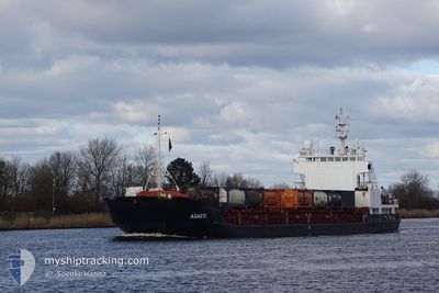
AGAETE
General Cargo
Current Trip
| Time Travelled | 3 days |
|---|---|
| Remaining Time | 1 day |
| Distance Travelled | 747.77 nm |
| Remaining Distance | 383.02 nm |
| AVG Speed | 7.6 Knots |
| MAX Speed | 10.6 Knots |
| AVG Wind | 7.1 knots |
| MAX Wind | 21.6 knots |
| MIN Temp | 5.3°C / 41.54°F |
| MAX Temp | 17.5°C / 63.5°F |
| Draught | 5.2 m |
| Position Received | 23 h, 46 m ago |
Current Position
| Longitude | 16.55185° |
|---|---|
| Latitude | 55.98918° |
| Status | Under way using engine |
| Speed | 9.4 Knots |
| Course | 55.5° |
| Area | Baltic Sea |
| Station | T-AIS |
| Position Received | 23 h, 46 m ago |
Info
Information
The current position of AGAETE is in Baltic Sea with coordinates 55.98918° / 16.55185° as reported on 2024-05-09 09:54 by AIS to our vessel tracker app. The vessel's current speed is 9.4 Knots and is heading at the port of ST PETERSBURG. The estimated time of arrival as calculated by vessel tracking app is 2024-05-11 18:53 LT
The vessel AGAETE (IMO: 9044932, MMSI: 305783000) is a General Cargo that was built in 1991 ( 33 years old ). It's sailing under the flag of [AG] Antigua Barbuda.
In this page you can find informations about the vessels current position, last detected port calls, and current voyage information. If the vessels is not in coverage by AIS you will find the latest position.
The current position of AGAETE is detected by our AIS receivers and we are not responsible for the reliability of the data. The last position was recorded while the vessel was in Coverage by the Ais receivers of our vessel tracking app.
The current draught of AGAETE as reported by AIS is 5.2 meters
Weather
| Temperature | 5.2°C / 41.36°F |
|---|---|
| Wind Speed | 23 knots |
| Direction | 342° NNW |
| Pressure | 1017.8 hPa |
| Humidity | 80 % |
| Cloud Coverage | 8 % |
Featured Company
Last Port Calls
| Port | Arrival | Departure | Time In Port |
|---|---|---|---|
| 2024-05-05 14:48 | 2024-05-06 11:47 | 20 h | |
| 2024-05-05 13:50 | 2024-05-05 14:29 | 38 m | |
| 2024-05-04 13:52 | 2024-05-05 12:34 | 22 h | |
| 2024-05-02 17:09 | 2024-05-04 13:25 | 1 d | |
| 2024-05-02 14:47 | 2024-05-02 15:31 | 44 m | |
| 2024-05-02 08:53 | 2024-05-02 14:46 | 5 h | |
| 2024-05-02 07:46 | 2024-05-02 08:34 | 48 m | |
| 2024-04-30 12:44 | 2024-04-30 14:40 | 1 h | |
| 2024-04-26 20:16 | |||
| 2024-04-17 23:03 | 2024-04-17 23:45 | 42 m |
Most Visited Ports (Last year)
| Port | Arrivals | |
|---|---|---|
| 50 | ||
| 33 | ||
| 18 | ||
| 9 | ||
| 5 | ||
| 4 |
Last Trips
| Origin | Departure | Destination | Arrival | Distance | |
|---|---|---|---|---|---|
| 2024-05-05 16:29 | 2024-05-05 16:48 | 0.68 nm | |||
| 2024-05-05 14:34 | 2024-05-05 15:50 | 12.58 nm | |||
| 2024-05-04 15:25 | 2024-05-04 15:52 | 1.40 nm | |||
| 2024-05-02 17:31 | 2024-05-02 19:09 | 12.98 nm | |||
| 2024-05-02 16:46 | 2024-05-02 16:47 | 0.45 nm | |||
| 2024-05-02 10:34 | 2024-05-02 10:53 | 0.69 nm | |||
| 2024-04-30 16:40 | 2024-05-02 09:46 | 328.25 nm | |||
| 2024-04-26 23:16 | 2024-04-30 14:44 | 738.80 nm | |||
| 2024-04-18 01:02 | 2024-04-18 01:03 | 0.13 nm | |||
| 2024-04-17 14:16 | 2024-04-17 14:32 | 0.57 nm |
Events
| Time | Event | Details | Position / Dest | Info |
|---|---|---|---|---|
| 2024-05-09 10:01 | Status Changed | Default Under way using engine |
55.99983 / 16.57852
RULED
|
Speed: 9.4 kn Course: 55.5° |
| 2024-05-09 09:54 | OUT of Coverage |
55.98918 / 16.55185
Baltic Sea
RULED
|
Speed: 9.4 kn Course: 55.5° |
|
| 2024-05-09 09:46 | Status Changed | Under way using engine Default |
55.97817 / 16.52120
RULED
|
Speed: 9.4 kn Course: 60° |
| 2024-05-09 09:44 | Status Changed | Default Under way using engine |
55.97640 / 16.51607
RULED
|
Speed: 9.3 kn Course: 59° |
| 2024-05-09 05:02 | Change Sea Area | Swedish part of the Baltic Sea Danish part of the Kattegat |
55.61678 / 15.36868
Baltic Sea
RULED
|
Speed: 9.3 kn Course: 60.1° |
| 2024-05-08 22:44 | Detected in Sea | Danish part of the Kattegat |
54.99767 / 14.04945
Kattegat
RULED
|
Speed: 9.3 kn Course: 72° |
| 2024-05-08 22:20 | Change Sea Area | Swedish part of the Baltic Sea German part of the Baltic Sea |
54.97785 / 13.94898
Baltic Sea
RULED
|
Speed: 9.1 kn Course: 69.9° |
| 2024-05-08 14:11 | Change Sea Area | German part of the Baltic Sea Danish part of the Baltic Sea |
54.40285 / 12.09230
Baltic Sea
RULED
|
Speed: 9.1 kn Course: 89° |
| 2024-05-08 11:26 | Change Sea Area | Danish part of the Baltic Sea German part of the Baltic Sea |
54.49938 / 11.44512
Baltic Sea
RULED
|
Speed: 8.6 kn Course: 117.8° |
| 2024-05-08 10:10 | ETA Changed | 2024/05/11 16:00 2024/05/11 10:00 |
54.58267 / 11.16087
RULED
|
Speed: 8.8 kn Course: 82.2° |