
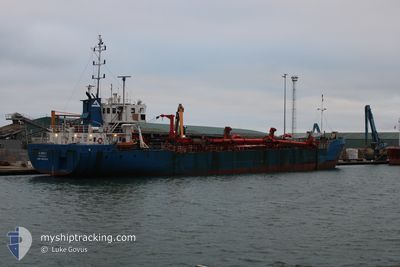
AI AVOCET
General Cargo
Current Trip
GBLSH
| Time Travelled | 8 days |
|---|---|
| Remaining Time | --- |
| Distance Travelled | 198.73 nm |
| Remaining Distance | --- |
| AVG Speed | 6.9 Knots |
| MAX Speed | 14.4 Knots |
| AVG Wind | 8.2 knots |
| MAX Wind | 18.8 knots |
| MIN Temp | 9.7°C / 49.46°F |
| MAX Temp | 16.5°C / 61.7°F |
| Draught | 4.3 m |
| Position Received | 2 m ago |
Current Position
| Longitude | -1.04113° |
|---|---|
| Latitude | 50.82438° |
| Status | Moored |
| Speed | |
| Course | 342° |
| Area | English Channel |
| Station | T-AIS |
| Position Received | 2 m ago |
Info
Information
The current position of AI AVOCET is in English Channel with coordinates 50.82438° / -1.04113° as reported on 2024-06-16 00:55 by AIS to our vessel tracker app. The vessel's current speed is 0 Knots
The vessel AI AVOCET (IMO: 8611233, MMSI: 235118074) is a General Cargo that was built in 1988 ( 36 years old ). It's sailing under the flag of [GB] United Kingdom.
In this page you can find informations about the vessels current position, last detected port calls, and current voyage information. If the vessels is not in coverage by AIS you will find the latest position.
The current position of AI AVOCET is detected by our AIS receivers and we are not responsible for the reliability of the data. The last position was recorded while the vessel was in Coverage by the Ais receivers of our vessel tracking app.
The current draught of AI AVOCET as reported by AIS is 4.3 meters
Weather
| Temperature | 13.3°C / 55.94°F |
|---|---|
| Wind Speed | 17 knots |
| Direction | 240° WSW |
| Pressure | 1001.9 hPa |
| Humidity | 80.9 % |
| Cloud Coverage | 35 % |
Featured Company
Last Port Calls
| Port | Arrival | Departure | Time In Port |
|---|---|---|---|
| 2024-06-07 09:08 | 2024-06-07 21:47 | 12 h | |
| 2024-06-06 09:00 | 2024-06-06 21:19 | 12 h | |
| 2024-05-18 06:33 | 2024-05-18 19:36 | 13 h | |
| 2024-05-17 05:44 | 2024-05-17 18:20 | 12 h | |
| 2024-05-09 11:44 | 2024-05-10 22:29 | 1 d | |
| 2024-04-22 21:28 | 2024-04-23 11:17 | 13 h | |
| 2024-04-11 12:51 | 2024-04-12 12:59 | 1 d | |
| 2024-04-01 13:19 | 2024-04-02 15:08 | 1 d | |
| 2024-04-01 00:07 |
Last Trips
| Origin | Departure | Destination | Arrival | Distance | |
|---|---|---|---|---|---|
| 2024-06-06 22:19 | 2024-06-07 10:08 | 64.36 nm | |||
| 2024-05-18 20:36 | 2024-06-06 10:00 | 588.56 nm | |||
| 2024-05-17 19:20 | 2024-05-18 07:33 | 61.34 nm | |||
| 2024-05-10 23:29 | 2024-05-17 06:44 | 182.34 nm | |||
| 2024-04-23 12:17 | 2024-05-09 12:44 | 315.99 nm | |||
| 2024-04-12 13:59 | 2024-04-22 22:28 | 203.17 nm | |||
| 2024-04-02 16:08 | 2024-04-11 13:51 | 90.01 nm | |||
| 2024-04-01 01:07 | 2024-04-01 14:19 | 67.10 nm |
Events
| Time | Event | Details | Position / Dest | Info |
|---|---|---|---|---|
| 2024-06-13 03:03 | Status Changed | Moored Under way using engine |
50.82434 / -1.04119
GBLSH
|
Speed: Course: 342° |
| 2024-06-13 02:53 | STOP Moving | 1.68 nm, North of EASTNEY |
50.82444 / -1.04092
GBLSH
|
Speed: 0.3 kn Course: 353° |
| 2024-06-13 01:56 | START Moving | 3.23 nm, South West of SPARKES |
50.74450 / -.99716
GBLSH
|
Speed: 3.1 kn Course: 308° |
| 2024-06-13 01:52 | Status Changed | Under way using engine At anchor |
50.74511 / -.99641
GBLSH
|
Speed: 0.9 kn Course: 168° |
| 2024-06-13 01:48 | Draught Changed | 4.3 4.4 |
50.74583 / -.99583
GBLSH
|
Speed: 0.1 kn Course: 166° |
| 2024-06-13 00:58 | STOP Moving | 3.12 nm, South West of SPARKES |
50.74556 / -.99463
GBLSH
|
Speed: 0.3 kn Course: 218° |
| 2024-06-13 00:49 | Status Changed | At anchor Under way using engine |
50.74457 / -.99411
GBLSH
|
Speed: 0.6 kn Course: 273° |
| 2024-06-12 23:46 | Draught Changed | 4.4 3.1 |
50.65436 / -.89491
GBLSH
|
Speed: 4.8 kn Course: 341° |
| 2024-06-12 23:45 | Status Changed | Under way using engine Restricted manoeuverability |
50.65369 / -.89494
GBLSH
|
Speed: 4.5 kn Course: 339° |
| 2024-06-12 23:43 | START Moving | 8.25 nm, South of SPARKES |
50.65183 / -.89535
GBLSH
|
Speed: 3.2 kn Course: 341° |