
ALAND
General Cargo
Current Trip
| Time Travelled | 22 h, 10 mins |
|---|---|
| Remaining Time | 9 h, 34 mins |
| Distance Travelled | 223.50 nm |
| Remaining Distance | 101.34 nm |
| AVG Speed | 10 Knots |
| MAX Speed | 10.9 Knots |
| AVG Wind | 15.1 knots |
| MAX Wind | 20.8 knots |
| MIN Temp | 4.4°C / 39.92°F |
| MAX Temp | 7.9°C / 46.22°F |
| Draught | 6.2 m |
| Position Received | Now |
Current Position
| Longitude | 24.17588° |
|---|---|
| Latitude | 59.65889° |
| Status | Under way using engine |
| Speed | 10.3 Knots |
| Course | 63.4° |
| Area | Gulf of Finland |
| Station | T-AIS |
| Position Received | Now |
Info
Information
The current position of ALAND is in Gulf of Finland with coordinates 59.65889° / 24.17588° as reported on 2024-05-06 20:02 by AIS to our vessel tracker app. The vessel's current speed is 10.3 Knots and is heading at the port of KOTKA. The estimated time of arrival as calculated by vessel tracking app is 2024-05-07 05:37 LT
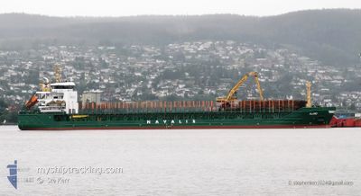
The vessel ALAND (IMO: 9350783, MMSI: 255802540) is a General Cargo that was built in 2007 ( 17 years old ). It's sailing under the flag of [PT] Portugal.
In this page you can find informations about the vessels current position, last detected port calls, and current voyage information. If the vessels is not in coverage by AIS you will find the latest position.
The current position of ALAND is detected by our AIS receivers and we are not responsible for the reliability of the data. The last position was recorded while the vessel was in Coverage by the Ais receivers of our vessel tracking app.
The current draught of ALAND as reported by AIS is 6.2 meters
Weather
| Temperature | 4.4°C / 39.92°F |
|---|---|
| Wind Speed | 13 knots |
| Direction | 82° E |
| Pressure | 1014.8 hPa |
| Humidity | 68.8 % |
| Cloud Coverage | 9 % |
Featured Company
Last Port Calls
| Port | Arrival | Departure | Time In Port |
|---|---|---|---|
| 2024-05-04 09:08 | 2024-05-05 21:53 | 1 d | |
| 2024-05-02 05:24 | 2024-05-02 22:47 | 17 h | |
| 2024-04-29 08:32 | 2024-04-30 17:08 | 1 d | |
| 2024-04-26 08:44 | 2024-04-28 11:16 | 2 d | |
| 2024-04-21 00:07 | 2024-04-22 08:18 | 1 d | |
| 2024-04-20 16:00 | |||
| 2024-04-16 06:11 | 2024-04-17 05:47 | 23 h | |
| 2024-04-08 17:34 | 2024-04-10 02:57 | 1 d | |
| 2024-04-05 17:29 | 2024-04-07 18:24 | 2 d | |
| 2024-03-31 15:37 | 2024-04-04 00:57 | 3 d |
Most Visited Ports (Last year)
| Port | Arrivals | |
|---|---|---|
| 9 | ||
| 8 | ||
| 4 | ||
| 4 | ||
| 4 | ||
| 4 |
Last Trips
| Origin | Departure | Destination | Arrival | Distance | |
|---|---|---|---|---|---|
| 2024-05-03 01:47 | 2024-05-04 12:08 | 331.98 nm | |||
| 2024-04-30 20:08 | 2024-05-02 08:24 | 332.58 nm | |||
| 2024-04-28 13:16 | 2024-04-29 11:32 | 228.13 nm | |||
| 2024-04-22 11:18 | 2024-04-26 10:44 | 122.05 nm | |||
| 2024-04-20 18:00 | 2024-04-21 03:07 | 90.46 nm | |||
| 2024-04-10 05:57 | 2024-04-16 09:11 | 747.46 nm | |||
| 2024-04-07 20:24 | 2024-04-08 20:34 | 231.72 nm | |||
| 2024-04-04 03:57 | 2024-04-05 19:29 | 432.24 nm | |||
| 2024-03-30 13:49 | 2024-03-31 18:37 | 262.20 nm | |||
| 2024-03-28 11:49 | 2024-03-28 22:14 | 112.57 nm |
Events
| Time | Event | Details | Position / Dest | Info |
|---|---|---|---|---|
| 2024-05-06 19:30 | Status Changed | Under way using engine Default |
59.60072 / 24.03711
FIKTK
|
Speed: 10.4 kn Course: 47° |
| 2024-05-06 19:27 | Status Changed | Default Under way using engine |
59.59537 / 24.02610
FIKTK
|
Speed: 10.5 kn Course: 48.9° |
| 2024-05-06 19:21 | Status Changed | Under way using engine Default |
59.58407 / 24.00096
FIKTK
|
Speed: 10.5 kn Course: 49° |
| 2024-05-06 19:20 | Status Changed | Default Under way using engine |
59.58219 / 23.99671
FIKTK
|
Speed: 10.5 kn Course: 49.3° |
| 2024-05-06 18:32 | Draught Changed | 6.2 4.3 |
59.50782 / 23.76318
FIKTK
|
Speed: 10.4 kn Course: 67.6° |
| 2024-05-06 18:32 | Destination Changed | FIKTK MERSRAGS |
59.50782 / 23.76318
FIKTK
|
Speed: 10.4 kn Course: 67.6° |
| 2024-05-06 18:32 | ETA Changed | 2024/05/07 07:00 2024/05/04 13:00 |
59.50782 / 23.76318
FIKTK
|
Speed: 10.4 kn Course: 67.6° |
| 2024-05-06 18:23 | Status Changed | Under way using engine Default |
59.49831 / 23.71731
MERSRAGS
|
Speed: 10.4 kn Course: 70° |
| 2024-05-06 18:23 | IN Coverage |
59.49921 / 23.72173
Gulf of Finland
|
Speed: 10.4 kn Course: 67.7° |
|
| 2024-05-06 17:09 | OUT of Coverage |
59.42137 / 23.31976
Gulf of Finland
|
Speed: 10.3 kn Course: 69.6° |