
ALAND
General Cargo
Current Trip
| Trip Time | 3 days |
|---|---|
| Trip Distance | 338.10 nm |
| AVG Speed | 10 Knots |
| MAX Speed | 13.2 Knots |
| Draught | 4.2 m |
| AVG Wind | 6.5 knots |
| MAX Wind | 13.9 knots |
| MIN Temp | 10.9°C / 51.62°F |
| MAX Temp | 23.1°C / 73.58°F |
| Position Received | 22 h, 31 m ago |
Current Position
| Longitude | 23.74645° |
|---|---|
| Latitude | 57.86133° |
| Status | Under way using engine |
| Speed | 11.1 Knots |
| Course | 152° |
| Area | Gulf of Riga |
| Station | T-AIS |
| Position Received | 22 h, 31 m ago |
Info
Information
The current position of ALAND is in Gulf of Riga with coordinates 57.86133° / 23.74645° as reported on 2024-05-31 17:11 by AIS to our vessel tracker app. The vessel's current speed is 11.1 Knots and is currently inside the port of SKULTE.
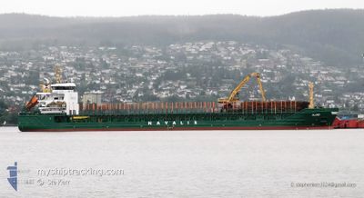
The vessel ALAND (IMO: 9350783, MMSI: 255802540) is a General Cargo that was built in 2007 ( 17 years old ). It's sailing under the flag of [PT] Portugal.
In this page you can find informations about the vessels current position, last detected port calls, and current voyage information. If the vessels is not in coverage by AIS you will find the latest position.
The current position of ALAND is detected by our AIS receivers and we are not responsible for the reliability of the data. The last position was recorded while the vessel was in Coverage by the Ais receivers of our vessel tracking app.
The current draught of ALAND as reported by AIS is 4.2 meters
Weather
| Temperature | 22.3°C / 72.14°F |
|---|---|
| Wind Speed | 2 knots |
| Direction | 94° E |
| Pressure | 1011.3 hPa |
| Humidity | 59.8 % |
| Cloud Coverage | 99 % |
Featured Company
Last Port Calls
| Port | Arrival | Departure | Time In Port |
|---|---|---|---|
| 2024-05-31 20:58 | |||
| 2024-05-27 06:27 | 2024-05-28 05:42 | 23 h | |
| 2024-05-21 20:07 | 2024-05-22 15:38 | 19 h | |
| 2024-05-19 12:24 | 2024-05-20 11:11 | 22 h | |
| 2024-05-16 23:01 | 2024-05-18 03:12 | 1 d | |
| 2024-05-15 13:20 | 2024-05-16 15:56 | 1 d | |
| 2024-05-14 04:13 | 2024-05-15 05:10 | 1 d | |
| 2024-05-12 11:48 | 2024-05-13 20:44 | 1 d | |
| 2024-05-10 06:47 | 2024-05-11 03:23 | 20 h | |
| 2024-05-04 09:08 | 2024-05-05 21:53 | 1 d |
Last Trips
| Origin | Departure | Destination | Arrival | Distance | |
|---|---|---|---|---|---|
| 2024-05-28 08:42 | 2024-05-31 23:58 | 338.10 nm | |||
| 2024-05-22 18:38 | 2024-05-27 09:27 | 426.86 nm | |||
| 2024-05-20 14:11 | 2024-05-21 23:07 | 366.29 nm | |||
| 2024-05-18 06:12 | 2024-05-19 15:24 | 345.13 nm | |||
| 2024-05-16 18:56 | 2024-05-17 02:01 | 77.98 nm | |||
| 2024-05-15 08:10 | 2024-05-15 16:20 | 78.21 nm | |||
| 2024-05-13 23:44 | 2024-05-14 07:13 | 78.44 nm | |||
| 2024-05-11 06:23 | 2024-05-12 14:48 | 338.88 nm | |||
| 2024-05-06 00:53 | 2024-05-10 09:47 | 650.04 nm | |||
| 2024-05-03 01:47 | 2024-05-04 12:08 | 331.98 nm |
Events
| Time | Event | Details | Position / Dest | Info |
|---|---|---|---|---|
| 2024-05-31 21:18 | STOP Moving |
57.31520 / 24.40221
[LV] SKULTE
|
Speed: 0.1 kn Course: 294° |
|
| 2024-05-31 20:58 | PORT ARRIVAL |
|
57.31692 / 24.39971
[LV] SKULTE
|
Speed: 3.5 kn Course: 95° |
| 2024-05-31 17:14 | Status Changed | Default Under way using engine |
57.85358 / 23.75418
SKULTE
|
Speed: 11.1 kn Course: 152° |
| 2024-05-31 17:11 | OUT of Coverage |
57.86133 / 23.74645
Gulf of Riga
SKULTE
|
Speed: 11.1 kn Course: 152° |
|
| 2024-05-31 17:11 | Detected in Sea | Latvian part of the Gulf of Riga |
57.86133 / 23.74645
Gulf of Riga
SKULTE
|
Speed: 11.1 kn Course: 152° |
| 2024-05-31 17:10 | Status Changed | Under way using engine Default |
57.86449 / 23.74329
SKULTE
|
Speed: 11.2 kn Course: 152° |
| 2024-05-31 16:48 | Status Changed | Default Under way using engine |
57.92411 / 23.68242
SKULTE
|
Speed: 11.1 kn Course: 151.5° |
| 2024-05-31 16:35 | Status Changed | Under way using engine Default |
57.96052 / 23.64538
SKULTE
|
Speed: 11 kn Course: 153° |
| 2024-05-31 16:26 | IN Coverage |
57.95868 / 23.64724
Gulf of Riga
SKULTE
|
Speed: 11.1 kn Course: 151.5° |
|
| 2024-05-31 14:53 | OUT of Coverage |
58.26922 / 23.52461
Gulf of Riga
SKULTE
|
Speed: 11.1 kn Course: 170.9° |