
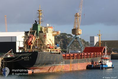
ALEXIA I
General Cargo
Current Trip
| Time Travelled | 3 days |
|---|---|
| Remaining Time | --- |
| Distance Travelled | 469.22 nm |
| Remaining Distance | --- |
| AVG Speed | 4.5 Knots |
| MAX Speed | 10.1 Knots |
| AVG Wind | 22 knots |
| MAX Wind | 28.9 knots |
| MIN Temp | 17.1°C / 62.78°F |
| MAX Temp | 20.6°C / 69.08°F |
| Draught | 4.1 m |
| Position Received | 7 h, 13 m ago |
Current Position
| Longitude | 19.14723° |
|---|---|
| Latitude | 40.05911° |
| Status | Under way using engine |
| Speed | 7 Knots |
| Course | 159° |
| Area | Adriatic Sea |
| Station | T-AIS |
| Position Received | 7 h, 13 m ago |
Info
Information
The current position of ALEXIA I is in Adriatic Sea with coordinates 40.05911° / 19.14723° as reported on 2024-05-17 21:40 by AIS to our vessel tracker app. The vessel's current speed is 7 Knots and is heading at the port of SYROS. The estimated time of arrival as calculated by vessel tracking app is 2024-05-20 12:00 LT
The vessel ALEXIA I (IMO: 9365049, MMSI: 538009439) is a General Cargo that was built in 2005 ( 19 years old ). It's sailing under the flag of [MH] Marshall Is.
In this page you can find informations about the vessels current position, last detected port calls, and current voyage information. If the vessels is not in coverage by AIS you will find the latest position.
The current position of ALEXIA I is detected by our AIS receivers and we are not responsible for the reliability of the data. The last position was recorded while the vessel was in Coverage by the Ais receivers of our vessel tracking app.
The current draught of ALEXIA I as reported by AIS is 4.1 meters
Weather
| Temperature | 19.4°C / 66.92°F |
|---|---|
| Wind Speed | 11 knots |
| Direction | 113° ESE |
| Pressure | 1013.7 hPa |
| Humidity | 90.6 % |
| Cloud Coverage | 97 % |
Featured Company
Last Trips
| Origin | Departure | Destination | Arrival | Distance | |
|---|---|---|---|---|---|
| 2024-04-28 14:28 | 2024-05-06 09:03 | 1233.95 nm | |||
| 2024-03-25 06:23 | 2024-04-04 11:02 | 871.42 nm |
Events
| Time | Event | Details | Position / Dest | Info |
|---|---|---|---|---|
| 2024-05-17 21:49 | Status Changed | Default Under way using engine |
40.04415 / 19.15477
GR JSY
|
Speed: 7 kn Course: 159° |
| 2024-05-17 21:40 | Detected in Sea | Greek part of the Adriatic Sea |
40.05911 / 19.14723
Adriatic Sea
GR JSY
|
Speed: 7 kn Course: 159° |
| 2024-05-17 21:40 | Status Changed | Under way using engine Default |
40.05911 / 19.14723
GR JSY
|
Speed: 6.9 kn Course: 159° |
| 2024-05-17 21:40 | OUT of Coverage |
40.05911 / 19.14723
Adriatic Sea
GR JSY
|
Speed: 7 kn Course: 159° |
|
| 2024-05-17 21:14 | Status Changed | Default Under way using engine |
40.10783 / 19.12510
GR JSY
|
Speed: 6.8 kn Course: 159° |
| 2024-05-17 21:05 | Status Changed | Under way using engine Default |
40.12422 / 19.11702
GR JSY
|
Speed: 6.8 kn Course: 159° |
| 2024-05-17 20:52 | IN Coverage |
40.12422 / 19.11702
Adriatic Sea
GR JSY
|
Speed: 6.8 kn Course: 159° |
|
| 2024-05-17 17:40 | Status Changed | Default Under way using engine |
40.49519 / 18.93154
GR JSY
|
Speed: 7.1 kn Course: 155.1° |
| 2024-05-17 17:20 | OUT of Coverage |
40.53184 / 18.90903
Adriatic Sea
GR JSY
|
Speed: 7.1 kn Course: 155.1° |
|
| 2024-05-17 16:25 | Destination Changed | GR JSY SYROS IS |
40.63056 / 18.84946
GR JSY
|
Speed: 6.9 kn Course: 157° |