
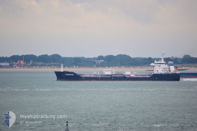
ALGOTITAN
Oil/Chemical Tanker
Current Trip
| Time Travelled | 3 h, 16 mins |
|---|---|
| Remaining Time | --- |
| Distance Travelled | 35.10 nm |
| Remaining Distance | --- |
| AVG Speed | 12 Knots |
| MAX Speed | 12.3 Knots |
| AVG Wind | 7.7 knots |
| MAX Wind | 11.9 knots |
| MIN Temp | 19°C / 66.2°F |
| MAX Temp | 20.2°C / 68.36°F |
| Draught | 6.2 m |
| Position Received | 1 m ago |
Current Position
| Longitude | -79.98640° |
|---|---|
| Latitude | 42.52860° |
| Status | Under way using engine |
| Speed | 12.1 Knots |
| Course | 241.3° |
| Area | Gulf of St-Lawrence |
| Station | T-AIS |
| Position Received | 1 m ago |
Info
Information
The current position of ALGOTITAN is in Gulf of St-Lawrence with coordinates 42.52860° / -79.98640° as reported on 2024-06-05 19:13 by AIS to our vessel tracker app. The vessel's current speed is 12.1 Knots and is heading at the port of SARNIA. The estimated time of arrival as calculated by vessel tracking app is 2024-06-06 12:00 LT
The vessel ALGOTITAN (IMO: 9333802, MMSI: 316050854) is a Oil/Chemical Tanker that was built in 2007 ( 17 years old ). It's sailing under the flag of [CA] Canada.
In this page you can find informations about the vessels current position, last detected port calls, and current voyage information. If the vessels is not in coverage by AIS you will find the latest position.
The current position of ALGOTITAN is detected by our AIS receivers and we are not responsible for the reliability of the data. The last position was recorded while the vessel was in Coverage by the Ais receivers of our vessel tracking app.
The current draught of ALGOTITAN as reported by AIS is 6.2 meters
Weather
| Temperature | 19°C / 66.2°F |
|---|---|
| Wind Speed | 12 knots |
| Direction | 178° S |
| Pressure | 1005.1 hPa |
| Humidity | 91.4 % |
| Cloud Coverage | 100 % |
Featured Company
Last Port Calls
| Port | Arrival | Departure | Time In Port |
|---|---|---|---|
| 2024-06-05 13:40 | 2024-06-05 15:59 | 2 h | |
| 2024-06-05 04:04 | 2024-06-05 05:45 | 1 h | |
| 2024-06-02 12:01 | 2024-06-03 11:00 | 22 h | |
| 2024-05-31 20:22 | 2024-05-31 21:14 | 51 m | |
| 2024-05-28 20:45 | 2024-05-31 08:37 | 2 d | |
| 2024-05-28 08:08 | 2024-05-28 09:17 | 1 h | |
| 2024-05-26 16:55 | 2024-05-26 17:31 | 35 m | |
| 2024-05-24 02:18 | 2024-05-24 04:05 | 1 h | |
| 2024-05-22 11:10 | 2024-05-22 13:37 | 2 h | |
| 2024-05-20 22:04 | 2024-05-22 00:14 | 1 d |
Most Visited Ports (Last year)
| Port | Arrivals | |
|---|---|---|
| 41 | ||
| 37 | ||
| 29 | ||
| 27 | ||
| 11 | ||
| 1 |
Last Trips
| Origin | Departure | Destination | Arrival | Distance | |
|---|---|---|---|---|---|
| 2024-06-05 01:45 | 2024-06-05 09:40 | 19.22 nm | |||
| 2024-06-03 07:00 | 2024-06-05 00:04 | 297.57 nm | |||
| 2024-05-31 17:14 | 2024-06-02 08:01 | 299.71 nm | |||
| 2024-05-31 04:37 | 2024-05-31 16:22 | 64.91 nm | |||
| 2024-05-28 05:17 | 2024-05-28 16:45 | 64.89 nm | |||
| 2024-05-26 13:31 | 2024-05-28 04:08 | 298.03 nm | |||
| 2024-05-24 00:05 | 2024-05-26 12:55 | 61.96 nm | |||
| 2024-05-22 09:37 | 2024-05-23 22:18 | 299.20 nm | |||
| 2024-05-21 20:14 | 2024-05-22 07:10 | 66.48 nm | |||
| 2024-05-20 07:54 | 2024-05-20 18:04 | 64.76 nm |
Events
| Time | Event | Details | Position / Dest | Info |
|---|---|---|---|---|
| 2024-06-05 15:59 | PORT DEPARTURE |
|
42.86903 / -79.25135
CASNI-003
|
Speed: 7.4 kn Course: 194° |
| 2024-06-05 15:53 | START Moving |
42.88025 / -79.24856
[CA] PORT COLBORNE
|
Speed: 4.5 kn Course: 182° |
|
| 2024-06-05 15:52 | Status Changed | Under way using engine Moored |
42.88106 / -79.24850
[CA] PORT COLBORNE
|
Speed: 3.2 kn Course: 182° |
| 2024-06-05 14:16 | Status Changed | Moored Under way using engine |
42.88251 / -79.24821
[CA] PORT COLBORNE
|
Speed: Course: 181° |
| 2024-06-05 13:41 | STOP Moving |
42.88278 / -79.24839
[CA] PORT COLBORNE
|
Speed: 0.3 kn Course: 175° |
|
| 2024-06-05 13:40 | PORT ARRIVAL |
|
42.88278 / -79.24839
[CA] PORT COLBORNE
|
Speed: 0.6 kn Course: 173° |
| 2024-06-05 13:25 | START Moving | 0.81 nm, North of PORT COLBORNE |
42.89485 / -79.24698
CASNI-003
|
Speed: 3.3 kn Course: 191° |
| 2024-06-05 13:11 | STOP Moving | 1.1 nm, North of PORT COLBORNE |
42.89958 / -79.24585
CASNI-003
|
Speed: 0.3 kn Course: 189° |
| 2024-06-05 10:54 | START Moving | 5.69 nm, South East of DALHOUSIE |
43.11976 / -79.19468
CASNI-003
|
Speed: 3.1 kn Course: 190° |
| 2024-06-05 08:55 | Status Changed | Under way using engine Default |
43.13682 / -79.19253
CASNI-003
|
Speed: Course: 183° |