
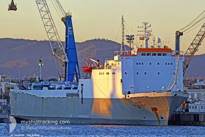
ALHUSSEIN
Ro-Ro Cargo
Current Trip
| Time Travelled | 3 days |
|---|---|
| Remaining Time | --- |
| Distance Travelled | 104.83 nm |
| Remaining Distance | --- |
| AVG Speed | 6 Knots |
| MAX Speed | 8.9 Knots |
| AVG Wind | 5.5 knots |
| MAX Wind | 18.8 knots |
| MIN Temp | 14.8°C / 58.64°F |
| MAX Temp | 22.3°C / 72.14°F |
| Draught | 4.1 m |
| Position Received | Now |
Current Position
| Longitude | 9.62722° |
|---|---|
| Latitude | 43.76276° |
| Status | Under way using engine |
| Speed | 0.5 Knots |
| Course | 267° |
| Area | Ligurian Sea |
| Station | T-AIS |
| Position Received | Now |
Info
Information
The current position of ALHUSSEIN is in Ligurian Sea with coordinates 43.76276° / 9.62722° as reported on 2024-06-03 00:11 by AIS to our vessel tracker app. The vessel's current speed is 0.5 Knots
The vessel ALHUSSEIN (IMO: 8318116, MMSI: 341414000) is a Ro-Ro Cargo that was built in 1985 ( 39 years old ). It's sailing under the flag of [KN] St Kitts Nevis.
In this page you can find informations about the vessels current position, last detected port calls, and current voyage information. If the vessels is not in coverage by AIS you will find the latest position.
The current position of ALHUSSEIN is detected by our AIS receivers and we are not responsible for the reliability of the data. The last position was recorded while the vessel was in Coverage by the Ais receivers of our vessel tracking app.
The current draught of ALHUSSEIN as reported by AIS is 4.1 meters
Weather
| Temperature | 18.4°C / 65.12°F |
|---|---|
| Wind Speed | 1 knots |
| Direction | 159° SSE |
| Pressure | 1014.2 hPa |
| Humidity | 72.7 % |
| Cloud Coverage | 56 % |
Featured Company
Last Port Calls
| Port | Arrival | Departure | Time In Port |
|---|---|---|---|
| 2024-05-29 17:31 | 2024-05-30 17:43 | 1 d | |
| 2024-05-27 06:10 | 2024-05-28 10:37 | 1 d | |
| 2024-05-22 06:44 | 2024-05-22 20:40 | 13 h | |
| 2024-05-18 05:22 | 2024-05-18 17:36 | 12 h | |
| 2024-05-15 09:34 | 2024-05-15 19:20 | 9 h | |
| 2024-05-14 09:48 | 2024-05-14 19:02 | 9 h | |
| 2024-05-03 17:10 | 2024-05-04 17:19 | 1 d | |
| 2024-04-27 19:25 | 2024-04-29 17:35 | 1 d | |
| 2024-04-26 04:04 | 2024-04-26 20:44 | 16 h | |
| 2024-04-16 19:35 | 2024-04-17 21:38 | 1 d |
Last Trips
| Origin | Departure | Destination | Arrival | Distance | |
|---|---|---|---|---|---|
| 2024-05-28 12:37 | 2024-05-29 19:31 | 272.89 nm | |||
| 2024-05-22 22:40 | 2024-05-27 08:10 | 850.39 nm | |||
| 2024-05-18 19:36 | 2024-05-22 08:44 | 810.41 nm | |||
| 2024-05-15 21:20 | 2024-05-18 07:22 | 493.00 nm | |||
| 2024-05-14 21:02 | 2024-05-15 11:34 | 35.66 nm | |||
| 2024-05-04 19:19 | 2024-05-14 11:48 | 1541.53 nm | |||
| 2024-04-29 19:35 | 2024-05-03 19:10 | 861.55 nm | |||
| 2024-04-26 22:44 | 2024-04-27 21:25 | 229.55 nm | |||
| 2024-04-17 23:38 | 2024-04-26 06:04 | 905.55 nm | |||
| 2024-04-11 02:48 | 2024-04-16 21:35 | 960.40 nm |
Events
| Time | Event | Details | Position / Dest | Info |
|---|---|---|---|---|
| 2024-06-02 05:35 | STOP Moving |
43.63235 / 9.53590
IT_GOA
|
Speed: 0.3 kn Course: 327° |
|
| 2024-06-01 17:38 | Detected in Sea | Italian part of the Ligurian Sea |
43.31105 / 9.54738
Ligurian Sea
IT_GOA
|
Speed: 5.5 kn Course: 340.8° |
| 2024-06-01 16:34 | Change Sea Area | Italian part of the Tyrrhenian Sea French part of the Tyrrhenian Sea |
43.21608 / 9.58353
Tyrrhenian Sea
IT_GOA
|
Speed: 5.6 kn Course: 345.2° |
| 2024-06-01 15:10 | Detected in Sea | French part of the Tyrrhenian Sea |
43.06826 / 9.63460
Tyrrhenian Sea
IT_GOA
|
Speed: 6.9 kn Course: 349.1° |
| 2024-06-01 14:44 | Detected in Sea | Italian part of the Tyrrhenian Sea |
43.01894 / 9.64717
Tyrrhenian Sea
IT_GOA
|
Speed: 6.9 kn Course: 349.6° |
| 2024-06-01 14:09 | Status Changed | Under way using engine Default |
42.94746 / 9.66667
IT_GOA
|
Speed: 8 kn Course: 354° |
| 2024-06-01 14:04 | Status Changed | Default Under way using engine |
42.93667 / 9.66833
IT_GOA
|
Speed: 8.6 kn Course: 354.9° |
| 2024-06-01 11:25 | START Moving | 10.02 nm, South East of BASTIA |
42.57650 / 9.61091
IT_GOA
|
Speed: 4.1 kn Course: 28° |
| 2024-06-01 11:03 | Destination Changed | IT_GOA FR_BIA |
42.57134 / 9.60807
IT_GOA
|
Speed: 0.1 kn Course: 42° |
| 2024-06-01 11:03 | ETA Changed | 2024/06/02 08:00 2025/05/29 13:00 |
42.57134 / 9.60807
IT_GOA
|
Speed: 0.1 kn Course: 42° |