
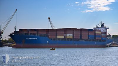
ALLSEAS PIONEER
General Cargo
Current Trip
| Time Travelled | 15 days |
|---|---|
| Remaining Time | 19 h, 20 mins |
| Distance Travelled | 4400.10 nm |
| Remaining Distance | 245.91 nm |
| AVG Speed | 11.3 Knots |
| MAX Speed | 14.1 Knots |
| AVG Wind | 10.1 knots |
| MAX Wind | 33.4 knots |
| MIN Temp | 9.6°C / 49.28°F |
| MAX Temp | 23.9°C / 75.02°F |
| Draught | 11 m |
| Position Received | 12 h, 1 m ago |
Current Position
| Longitude | 22.88288° |
|---|---|
| Latitude | 33.31544° |
| Status | Under way using engine |
| Speed | 11.7 Knots |
| Course | 109.7° |
| Area | Mediterranean Sea - Eastern Basin |
| Station | T-AIS |
| Position Received | 12 h, 1 m ago |
Info
Information
The current position of ALLSEAS PIONEER is in Mediterranean Sea - Eastern Basin with coordinates 33.31544° / 22.88288° as reported on 2024-06-09 09:46 by AIS to our vessel tracker app. The vessel's current speed is 11.7 Knots and is heading at the port of EL DEKHEILA. The estimated time of arrival as calculated by vessel tracking app is 2024-06-10 17:08 LT
The vessel ALLSEAS PIONEER (IMO: 9262558, MMSI: 636093075) is a General Cargo that was built in 2003 ( 21 years old ). It's sailing under the flag of [LR] Liberia.
In this page you can find informations about the vessels current position, last detected port calls, and current voyage information. If the vessels is not in coverage by AIS you will find the latest position.
The current position of ALLSEAS PIONEER is detected by our AIS receivers and we are not responsible for the reliability of the data. The last position was recorded while the vessel was in Coverage by the Ais receivers of our vessel tracking app.
The current draught of ALLSEAS PIONEER as reported by AIS is 11 meters
Weather
| Temperature | 23.5°C / 74.3°F |
|---|---|
| Wind Speed | 11 knots |
| Direction | 308° NW |
| Pressure | 1011.2 hPa |
| Humidity | 85.8 % |
| Cloud Coverage | --- |
Featured Company
Last Port Calls
| Port | Arrival | Departure | Time In Port |
|---|---|---|---|
| 2024-05-23 15:26 | 2024-05-24 22:38 | 1 d | |
| 2024-05-20 04:25 | 2024-05-22 21:33 | 2 d | |
| 2024-04-29 15:02 | 2024-05-02 03:17 | 2 d | |
| 2024-04-25 06:14 | 2024-04-25 13:21 | 7 h | |
| 2024-04-24 17:00 | 2024-04-25 00:54 | 7 h | |
| 2024-04-21 03:55 | 2024-04-21 13:19 | 9 h | |
| 2024-04-17 15:27 | 2024-04-18 12:17 | 20 h | |
| 2024-04-15 03:46 | 2024-04-15 12:14 | 8 h | |
| 2024-04-04 21:48 | 2024-04-07 11:22 | 2 d |
Most Visited Ports (Last year)
| Port | Arrivals | |
|---|---|---|
| 7 | ||
| 3 | ||
| 3 | ||
| 2 | ||
| 2 | ||
| 2 |
Last Trips
| Origin | Departure | Destination | Arrival | Distance | |
|---|---|---|---|---|---|
| 2024-05-23 00:33 | 2024-05-23 18:26 | 51.56 nm | |||
| 2024-05-02 06:17 | 2024-05-20 07:25 | 5111.31 nm | |||
| 2024-04-25 16:21 | 2024-04-29 18:02 | 539.16 nm | |||
| 2024-04-25 03:54 | 2024-04-25 09:14 | 55.08 nm | |||
| 2024-04-18 15:17 | 2024-04-24 20:00 | 1514.29 nm | |||
| 2024-04-18 15:17 | 2024-04-21 05:55 | 626.92 nm | |||
| 2024-04-07 14:22 | 2024-04-17 18:27 | 2080.59 nm | |||
| 2024-04-07 14:22 | 2024-04-15 05:46 | 1360.02 nm | |||
| 2024-03-29 11:27 | 2024-04-05 00:48 | 1471.33 nm |
Events
| Time | Event | Details | Position / Dest | Info |
|---|---|---|---|---|
| 2024-06-09 09:52 | Status Changed | Default Under way using engine |
33.30968 / 22.90170
EGEDK
|
Speed: 11.7 kn Course: 109.7° |
| 2024-06-09 09:46 | OUT of Coverage |
33.31544 / 22.88288
Mediterranean Sea - Eastern Basin
EGEDK
|
Speed: 11.7 kn Course: 109.7° |
|
| 2024-06-09 09:07 | Status Changed | Under way using engine Default |
33.35726 / 22.74064
EGEDK
|
Speed: 11.6 kn Course: 108° |
| 2024-06-09 08:48 | IN Coverage |
33.35726 / 22.74064
Mediterranean Sea - Eastern Basin
EGEDK
|
Speed: 11.6 kn Course: 108.8° |
|
| 2024-06-09 01:24 | Status Changed | Default Under way using engine |
33.86666 / 20.99833
EGEDK
|
Speed: 11.9 kn Course: 108° |
| 2024-06-09 01:19 | Status Changed | Under way using engine Default |
33.87173 / 20.98127
EGEDK
|
Speed: 11 kn Course: 108° |
| 2024-06-09 01:19 | OUT of Coverage |
33.87173 / 20.98127
Mediterranean Sea - Eastern Basin
EGEDK
|
Speed: 11.9 kn Course: 108° |
|
| 2024-06-09 01:07 | IN Coverage |
33.87173 / 20.98127
Mediterranean Sea - Eastern Basin
EGEDK
|
Speed: 11.9 kn Course: 108° |
|
| 2024-06-09 00:03 | Status Changed | Default Under way using engine |
33.95430 / 20.70112
EGEDK
|
Speed: 11.5 kn Course: 109.6° |
| 2024-06-08 23:59 | OUT of Coverage |
33.95850 / 20.68721
Mediterranean Sea - Eastern Basin
EGEDK
|
Speed: 11.5 kn Course: 109.6° |