
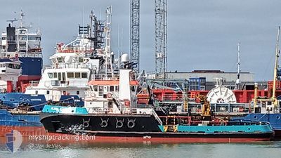
ALMA KAPPA
Tug
Current Trip
| Time Travelled | 8 days |
|---|---|
| Remaining Time | --- |
| Distance Travelled | 852.88 nm |
| Remaining Distance | --- |
| AVG Speed | 4.5 Knots |
| MAX Speed | 10.8 Knots |
| AVG Wind | 15.7 knots |
| MAX Wind | 20 knots |
| MIN Temp | 11.8°C / 53.24°F |
| MAX Temp | 17.4°C / 63.32°F |
| Draught | 4 m |
| Position Received | 1 m ago |
Current Position
| Longitude | -2.54617° |
|---|---|
| Latitude | 46.95262° |
| Status | Under way using engine |
| Speed | 3.5 Knots |
| Course | 261° |
| Area | Bay of Biscay |
| Station | T-AIS |
| Position Received | 1 m ago |
Info
Information
The current position of ALMA KAPPA is in Bay of Biscay with coordinates 46.95262° / -2.54617° as reported on 2024-06-02 10:48 by AIS to our vessel tracker app. The vessel's current speed is 3.5 Knots
The vessel ALMA KAPPA (IMO: 9467500, MMSI: 228396600) is a Tug that was built in 2008 ( 16 years old ). It's sailing under the flag of [FR] France.
In this page you can find informations about the vessels current position, last detected port calls, and current voyage information. If the vessels is not in coverage by AIS you will find the latest position.
The current position of ALMA KAPPA is detected by our AIS receivers and we are not responsible for the reliability of the data. The last position was recorded while the vessel was in Coverage by the Ais receivers of our vessel tracking app.
The current draught of ALMA KAPPA as reported by AIS is 4 meters
Weather
| Temperature | 15.7°C / 60.26°F |
|---|---|
| Wind Speed | 12 knots |
| Direction | 35° NE |
| Pressure | 1025.9 hPa |
| Humidity | 77.2 % |
| Cloud Coverage | 14 % |
Featured Company
Last Port Calls
| Port | Arrival | Departure | Time In Port |
|---|---|---|---|
| 2024-05-24 05:06 | 2024-05-25 05:14 | 1 d | |
| 2024-05-13 16:24 | 2024-05-17 16:37 | 4 d | |
| 2024-05-05 16:12 | 2024-05-08 05:14 | 2 d | |
| 2024-05-04 05:40 |
Most Visited Ports (Last year)
| Port | Arrivals | |
|---|---|---|
| 21 | ||
| 11 | ||
| 4 | ||
| 2 | ||
| 1 |
Last Trips
| Origin | Departure | Destination | Arrival | Distance | |
|---|---|---|---|---|---|
| 2024-05-17 18:37 | 2024-05-24 07:06 | 330.71 nm | |||
| 2024-05-08 07:14 | 2024-05-13 18:24 | 284.61 nm | |||
| 2024-05-04 07:40 | 2024-05-05 18:12 | 144.98 nm |
Events
| Time | Event | Details | Position / Dest | Info |
|---|---|---|---|---|
| 2024-06-01 12:10 | Status Changed | Under way using engine Default |
46.90801 / -2.58016
FR SNR
|
Speed: 2.8 kn Course: 347° |
| 2024-06-01 12:07 | Status Changed | Default Under way using engine |
46.90624 / -2.57895
FR SNR
|
Speed: 2.8 kn Course: 348° |
| 2024-06-01 00:09 | ETA Changed | 2025/05/05 18:30 2024/05/05 18:30 |
46.88559 / -2.56593
FR SNR
|
Speed: 2.9 kn Course: 332° |
| 2024-05-26 14:22 | Status Changed | Under way using engine Default |
46.93899 / -2.57647
FR SNR
|
Speed: 3.2 kn Course: 237° |
| 2024-05-26 14:17 | Status Changed | Default Under way using engine |
46.94158 / -2.57139
FR SNR
|
Speed: 3.2 kn Course: 231° |
| 2024-05-25 22:43 | Status Changed | Under way using engine Default |
46.89299 / -2.59520
FR SNR
|
Speed: 3 kn Course: -1° |
| 2024-05-25 22:38 | Status Changed | Default Under way using engine |
46.89667 / -2.59500
FR SNR
|
Speed: 3.2 kn Course: 173° |
| 2024-05-25 05:14 | PORT DEPARTURE |
|
47.26438 / -2.20453
FR SNR
|
Speed: 7.3 kn Course: 209° |
| 2024-05-25 05:11 | START Moving |
47.26955 / -2.20248
[FR] ST NAZAIRE
|
Speed: 5.4 kn Course: 191° |
|
| 2024-05-25 05:09 | Status Changed | Under way using engine Default |
47.27147 / -2.20207
[FR] ST NAZAIRE
|
Speed: Course: 193° |