
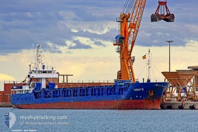
ALYA
General Cargo
Current Trip
| Time Travelled | 1 day |
|---|---|
| Remaining Time | --- |
| Distance Travelled | 152.77 nm |
| Remaining Distance | --- |
| AVG Speed | 8.4 Knots |
| MAX Speed | 8.4 Knots |
| AVG Wind | 4.3 knots |
| MAX Wind | 6.3 knots |
| MIN Temp | 18.4°C / 65.12°F |
| MAX Temp | 25.5°C / 77.9°F |
| Draught | 5.4 m |
| Position Received | 3 m ago |
Current Position
| Longitude | 29.19433° |
|---|---|
| Latitude | 40.87188° |
| Status | At anchor |
| Speed | |
| Course | 128° |
| Area | Sea of Marmara |
| Station | T-AIS |
| Position Received | 3 m ago |
Info
Information
The current position of ALYA is in Sea of Marmara with coordinates 40.87188° / 29.19433° as reported on 2024-06-01 09:53 by AIS to our vessel tracker app. The vessel's current speed is 0 Knots and is heading at the port of NAPOLI. The estimated time of arrival as calculated by vessel tracking app is 2024-06-05 08:00 LT
The vessel ALYA (IMO: 9133513, MMSI: 357890000) is a General Cargo that was built in 1995 ( 29 years old ). It's sailing under the flag of [PA] Panama.
In this page you can find informations about the vessels current position, last detected port calls, and current voyage information. If the vessels is not in coverage by AIS you will find the latest position.
The current position of ALYA is detected by our AIS receivers and we are not responsible for the reliability of the data. The last position was recorded while the vessel was in Coverage by the Ais receivers of our vessel tracking app.
The current draught of ALYA as reported by AIS is 5.4 meters
Weather
| Temperature | 20.5°C / 68.9°F |
|---|---|
| Wind Speed | 4 knots |
| Direction | 323° NW |
| Pressure | 1018.5 hPa |
| Humidity | 67.6 % |
| Cloud Coverage | --- |
Featured Company
Last Port Calls
| Port | Arrival | Departure | Time In Port |
|---|---|---|---|
| 2024-05-29 18:38 | 2024-05-30 16:26 | 21 h | |
| 2024-05-25 12:17 | |||
| 2024-05-11 10:46 | 2024-05-13 17:25 | 2 d | |
| 2024-05-08 04:05 | 2024-05-08 23:08 | 19 h | |
| 2024-04-30 08:32 | 2024-05-02 17:28 | 2 d | |
| 2024-04-16 10:32 | 2024-04-17 01:35 | 15 h | |
| 2024-04-09 04:54 | 2024-04-09 08:17 | 3 h |
Most Visited Ports (Last year)
| Port | Arrivals | |
|---|---|---|
| 8 | ||
| 2 | ||
| 2 | ||
| 2 | ||
| 2 | ||
| 2 |
Last Trips
| Origin | Departure | Destination | Arrival | Distance | |
|---|---|---|---|---|---|
| 2024-05-25 15:17 | 2024-05-29 21:38 | 176.42 nm | |||
| 2024-05-09 01:08 | 2024-05-11 11:46 | 520.43 nm | |||
| 2024-05-02 19:28 | 2024-05-08 06:05 | 515.41 nm | |||
| 2024-04-17 04:35 | 2024-04-30 10:32 | 1652.32 nm | |||
| 2024-04-09 11:17 | 2024-04-16 13:32 | 413.41 nm | |||
| 2024-03-31 14:46 | 2024-04-09 07:54 | 933.08 nm |
Events
| Time | Event | Details | Position / Dest | Info |
|---|---|---|---|---|
| 2024-06-01 09:53 | Status Changed | At anchor Default |
40.87188 / 29.19433
IT NAP
|
Speed: Course: 136° |
| 2024-06-01 09:47 | Status Changed | Default At anchor |
40.87194 / 29.19433
IT NAP
|
Speed: Course: 136° |
| 2024-06-01 09:22 | Status Changed | At anchor Default |
40.87206 / 29.19445
IT NAP
|
Speed: Course: 146° |
| 2024-06-01 09:16 | Status Changed | Default At anchor |
40.87205 / 29.19449
IT NAP
|
Speed: Course: 148° |
| 2024-06-01 08:16 | Status Changed | At anchor Default |
40.87200 / 29.19429
IT NAP
|
Speed: Course: 126° |
| 2024-06-01 08:13 | Status Changed | Default At anchor |
40.87198 / 29.19427
IT NAP
|
Speed: Course: 128° |
| 2024-06-01 07:35 | Status Changed | At anchor Default |
40.87208 / 29.19444
IT NAP
|
Speed: Course: 144° |
| 2024-06-01 07:29 | Status Changed | Default At anchor |
40.87209 / 29.19449
IT NAP
|
Speed: Course: 144° |
| 2024-06-01 06:34 | Status Changed | At anchor Default |
40.87227 / 29.19475
IT NAP
|
Speed: Course: 153° |
| 2024-06-01 06:26 | Status Changed | Default At anchor |
40.87225 / 29.19470
IT NAP
|
Speed: Course: 153° |