
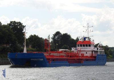
AMADEUS TITANIUM
General Cargo
Current Trip
| Time Travelled | 1 day |
|---|---|
| Remaining Time | 2 days |
| Distance Travelled | 359.36 nm |
| Remaining Distance | 505.78 nm |
| AVG Speed | 7.9 Knots |
| MAX Speed | 10 Knots |
| AVG Wind | 12.2 knots |
| MAX Wind | 18.9 knots |
| MIN Temp | 13.9°C / 57.02°F |
| MAX Temp | 15.8°C / 60.44°F |
| Draught | 4 m |
| Position Received | 7 h, 50 m ago |
Current Position
| Longitude | -5.49145° |
|---|---|
| Latitude | 47.87770° |
| Status | Under way using engine |
| Speed | 7.7 Knots |
| Course | 349.9° |
| Area | Celtic Sea |
| Station | T-AIS |
| Position Received | 7 h, 50 m ago |
Info
Information
The current position of AMADEUS TITANIUM is in Celtic Sea with coordinates 47.87770° / -5.49145° as reported on 2024-05-22 20:50 by AIS to our vessel tracker app. The vessel's current speed is 7.7 Knots and is heading at the port of MOERDIJK. The estimated time of arrival as calculated by vessel tracking app is 2024-05-25 18:59 LT
The vessel AMADEUS TITANIUM (IMO: 9350460, MMSI: 246776000) is a General Cargo that was built in 2006 ( 18 years old ). It's sailing under the flag of [NL] Netherlands.
In this page you can find informations about the vessels current position, last detected port calls, and current voyage information. If the vessels is not in coverage by AIS you will find the latest position.
The current position of AMADEUS TITANIUM is detected by our AIS receivers and we are not responsible for the reliability of the data. The last position was recorded while the vessel was in Coverage by the Ais receivers of our vessel tracking app.
The current draught of AMADEUS TITANIUM as reported by AIS is 4 meters
Weather
| Temperature | 14.4°C / 57.92°F |
|---|---|
| Wind Speed | 9 knots |
| Direction | 294° WNW |
| Pressure | 1015.5 hPa |
| Humidity | 84.1 % |
| Cloud Coverage | 8 % |
Featured Company
Last Port Calls
| Port | Arrival | Departure | Time In Port |
|---|---|---|---|
| 2024-05-20 17:53 | 2024-05-21 09:40 | 15 h | |
| 2024-05-16 04:17 | 2024-05-16 17:19 | 13 h | |
| 2024-05-12 16:45 | 2024-05-16 03:21 | 3 d | |
| 2024-05-10 06:27 | 2024-05-10 20:34 | 14 h | |
| 2024-05-08 10:56 | 2024-05-08 19:30 | 8 h | |
| 2024-05-06 09:56 | 2024-05-06 22:41 | 12 h | |
| 2024-05-04 08:36 | 2024-05-04 23:30 | 14 h | |
| 2024-04-28 07:17 | 2024-05-03 10:45 | 5 d | |
| 2024-04-26 11:41 | 2024-04-27 06:10 | 18 h | |
| 2024-04-24 00:30 | 2024-04-24 20:15 | 19 h |
Last Trips
| Origin | Departure | Destination | Arrival | Distance | |
|---|---|---|---|---|---|
| 2024-05-16 19:19 | 2024-05-20 19:53 | 824.82 nm | |||
| 2024-05-16 05:21 | 2024-05-16 06:17 | 6.88 nm | |||
| 2024-05-10 22:34 | 2024-05-12 18:45 | 321.59 nm | |||
| 2024-05-08 21:30 | 2024-05-10 08:27 | 317.30 nm | |||
| 2024-05-07 00:41 | 2024-05-08 12:56 | 309.07 nm | |||
| 2024-05-05 01:30 | 2024-05-06 11:56 | 296.06 nm | |||
| 2024-05-03 12:45 | 2024-05-04 10:36 | 165.42 nm | |||
| 2024-04-27 08:10 | 2024-04-28 09:17 | 223.30 nm | |||
| 2024-04-24 22:15 | 2024-04-26 13:41 | 317.13 nm | |||
| 2024-04-21 22:53 | 2024-04-24 02:30 | 446.89 nm |
Events
| Time | Event | Details | Position / Dest | Info |
|---|---|---|---|---|
| 2024-05-22 20:52 | Status Changed | Default Under way using engine |
47.88167 / -5.49167
NLMOE
|
Speed: 7.7 kn Course: 349.9° |
| 2024-05-22 20:50 | Status Changed | Under way using engine Default |
47.87770 / -5.49145
NLMOE
|
Speed: 7 kn Course: 353° |
| 2024-05-22 20:50 | IN Coverage |
47.87770 / -5.49145
Celtic Sea
NLMOE
|
Speed: 7.7 kn Course: 349.9° |
|
| 2024-05-22 20:50 | OUT of Coverage |
47.87770 / -5.49145
Celtic Sea
NLMOE
|
Speed: 7.7 kn Course: 349.9° |
|
| 2024-05-22 20:50 | Detected in Sea | French part of the Celtic Sea |
47.87770 / -5.49145
Celtic Sea
NLMOE
|
Speed: 7.7 kn Course: 349.9° |
| 2024-05-21 09:54 | Status Changed | Default Under way using engine |
43.41383 / -3.08970
NLMOE
|
Speed: 8.1 kn Course: 353.1° |
| 2024-05-21 09:49 | OUT of Coverage |
43.40203 / -3.08406
Bay of Biscay
NLMOE
|
Speed: 8.1 kn Course: 353.1° |
|
| 2024-05-21 09:40 | PORT DEPARTURE |
|
43.38212 / -3.08116
NLMOE
|
Speed: 8.5 kn Course: 1° |
| 2024-05-21 09:37 | Status Changed | Under way using engine Moored |
43.37463 / -3.08198
[ES] BILBAO
|
Speed: 8.6 kn Course: 23° |
| 2024-05-21 09:33 | Draught Changed | 4 4.7 |
43.36812 / -3.09246
[ES] BILBAO
|
Speed: 8 kn Course: 67° |