
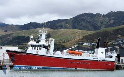
AMALTAL MARINER
Fishing
Current Trip
PORT NELSON
| Time Travelled | 3 days |
|---|---|
| Remaining Time | --- |
| Distance Travelled | 130.55 nm |
| Remaining Distance | --- |
| AVG Speed | 9.9 Knots |
| MAX Speed | 12.6 Knots |
| AVG Wind | 4.6 knots |
| MAX Wind | 12.1 knots |
| MIN Temp | 8.6°C / 47.48°F |
| MAX Temp | 11.9°C / 53.42°F |
| Draught | 5.5 m |
| Position Received | 2 d ago |
Current Position
| Longitude | 175.28191° |
|---|---|
| Latitude | -41.66690° |
| Status | Under way using engine |
| Speed | 9.5 Knots |
| Course | 70.3° |
| Area | South Pacific Ocean |
| Station | T-AIS |
| Position Received | 2 d ago |
Info
Information
The current position of AMALTAL MARINER is in South Pacific Ocean with coordinates -41.66690° / 175.28191° as reported on 2024-06-27 18:54 by AIS to our vessel tracker app. The vessel's current speed is 9.5 Knots
The vessel AMALTAL MARINER (IMO: 9132466, MMSI: 512002681) is a Fishing It's sailing under the flag of [NZ] New Zealand.
In this page you can find informations about the vessels current position, last detected port calls, and current voyage information. If the vessels is not in coverage by AIS you will find the latest position.
The current position of AMALTAL MARINER is detected by our AIS receivers and we are not responsible for the reliability of the data. The last position was recorded while the vessel was in Coverage by the Ais receivers of our vessel tracking app.
The current draught of AMALTAL MARINER as reported by AIS is 5.5 meters
Weather
| Temperature | 10.9°C / 51.62°F |
|---|---|
| Wind Speed | 7 knots |
| Direction | 31° NNE |
| Pressure | 1021.9 hPa |
| Humidity | 75.4 % |
| Cloud Coverage | 3 % |
Featured Company
Last Port Calls
| Port | Arrival | Departure | Time In Port |
|---|---|---|---|
| 2024-06-23 16:56 | 2024-06-27 03:41 | 3 d | |
| 2024-06-06 19:46 | 2024-06-23 16:14 | 16 d | |
| 2024-05-18 22:20 | 2024-06-02 21:01 | 14 d | |
| 2024-05-17 18:50 | 2024-05-18 21:36 | 1 d | |
| 2024-05-07 19:21 | 2024-05-07 23:20 | 3 h | |
| 2024-04-26 21:04 | 2024-05-06 23:05 | 10 d | |
| 2024-04-17 15:36 | 2024-04-18 19:20 | 1 d | |
| 2024-04-10 00:53 |
Most Visited Ports (Last year)
| Port | Arrivals | |
|---|---|---|
| 9 |
Last Trips
| Origin | Departure | Destination | Arrival | Distance | |
|---|---|---|---|---|---|
| 2024-06-24 04:14 | 2024-06-24 04:56 | 3.13 nm | |||
| 2024-06-03 09:01 | 2024-06-07 07:46 | 506.63 nm | |||
| 2024-05-19 09:36 | 2024-05-19 10:20 | 3.30 nm | |||
| 2024-05-08 11:20 | 2024-05-18 06:50 | 453.39 nm | |||
| 2024-05-07 11:05 | 2024-05-08 07:21 | 127.68 nm | |||
| 2024-04-19 07:20 | 2024-04-27 09:04 | 290.83 nm | |||
| 2024-04-10 12:53 | 2024-04-18 03:36 | 302.03 nm |
Events
| Time | Event | Details | Position / Dest | Info |
|---|---|---|---|---|
| 2024-06-27 18:54 | OUT of Coverage |
-41.66690 / 175.28191
South Pacific Ocean
|
Speed: 9.5 kn Course: 70.3° |
|
| 2024-06-27 18:54 | Change Sea Area | New Zealand part of the South Pacific Ocean New Zealand part of the Tasman Sea |
-41.66690 / 175.28191
South Pacific Ocean
|
Speed: 9.5 kn Course: 70.3° |
| 2024-06-27 18:54 | IN Coverage |
-41.66690 / 175.28191
South Pacific Ocean
|
Speed: 9.5 kn Course: 70.3° |
|
| 2024-06-27 17:46 | OUT of Coverage |
-41.58765 / 175.05902
Tasman Sea
|
Speed: 10 kn Course: 121.8° |
|
| 2024-06-27 11:13 | IN Coverage |
-40.77908 / 174.17885
Tasman Sea
|
Speed: 9.2 kn Course: 142° |
|
| 2024-06-27 10:05 | OUT of Coverage |
-40.64584 / 174.03622
Tasman Sea
|
Speed: 8.9 kn Course: 134.9° |
|
| 2024-06-27 04:55 | START Moving | 1.42 nm, North West of NELSON |
-41.23885 / 173.25472
PORT NELSON
|
Speed: 3.9 kn Course: 53° |
| 2024-06-27 04:04 | STOP Moving | 1.23 nm, North West of NELSON |
-41.24544 / 173.25252
PORT NELSON
|
Speed: 0.3 kn Course: 59° |
| 2024-06-27 03:41 | PORT DEPARTURE |
|
-41.26339 / 173.26504
PORT NELSON
|
Speed: 7 kn Course: 230° |
| 2024-06-27 03:31 | START Moving |
-41.25505 / 173.27986
[NZ] NELSON
|
Speed: 3.9 kn Course: 293° |