
AMBER LIGHT
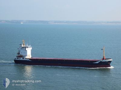
General Cargo
Current Trip
| Time Travelled | 1 day |
|---|---|
| Remaining Time | 6 days |
| Distance Travelled | 191.99 nm |
| Remaining Distance | 1112.99 nm |
| AVG Speed | 8 Knots |
| MAX Speed | 9.8 Knots |
| AVG Wind | 14.7 knots |
| MAX Wind | 22.5 knots |
| MIN Temp | 9.3°C / 48.74°F |
| MAX Temp | 15.3°C / 59.54°F |
| Draught | 5.8 m |
| Position Received | 1 m ago |
Current Position
| Longitude | 23.08473° |
|---|---|
| Latitude | 59.61548° |
| Status | Under way using engine |
| Speed | 5.7 Knots |
| Course | 256° |
| Area | Gulf of Finland |
| Station | T-AIS |
| Position Received | 1 m ago |
Info
Information
The current position of AMBER LIGHT is in Gulf of Finland with coordinates 59.61548° / 23.08473° as reported on 2024-06-10 13:05 by AIS to our vessel tracker app. The vessel's current speed is 5.7 Knots and is heading at the port of TERNEUZEN. The estimated time of arrival as calculated by vessel tracking app is 2024-06-16 17:42 LT
The vessel AMBER LIGHT (IMO: 9158109, MMSI: 304778000) is a General Cargo that was built in 2005 ( 19 years old ). It's sailing under the flag of [AG] Antigua Barbuda.
In this page you can find informations about the vessels current position, last detected port calls, and current voyage information. If the vessels is not in coverage by AIS you will find the latest position.
The current position of AMBER LIGHT is detected by our AIS receivers and we are not responsible for the reliability of the data. The last position was recorded while the vessel was in Coverage by the Ais receivers of our vessel tracking app.
The current draught of AMBER LIGHT as reported by AIS is 5.8 meters
Weather
| Temperature | 12°C / 53.6°F |
|---|---|
| Wind Speed | 21 knots |
| Direction | 212° SSW |
| Pressure | 1000.7 hPa |
| Humidity | 77.2 % |
| Cloud Coverage | 4 % |
Featured Company
Last Port Calls
| Port | Arrival | Departure | Time In Port |
|---|---|---|---|
| 2024-06-05 23:53 | 2024-06-09 09:04 | 3 d | |
| 2024-05-31 01:18 | 2024-05-31 14:36 | 13 h | |
| 2024-05-29 22:55 | 2024-05-31 01:08 | 1 d | |
| 2024-05-28 16:13 | 2024-05-29 21:45 | 1 d | |
| 2024-05-15 08:00 | 2024-05-21 03:27 | 5 d | |
| 2024-05-02 08:20 | 2024-05-06 11:52 | 4 d | |
| 2024-04-29 21:52 | 2024-04-30 12:01 | 14 h | |
| 2024-04-24 22:08 | 2024-04-27 16:16 | 2 d | |
| 2024-04-23 04:55 | 2024-04-24 12:03 | 1 d | |
| 2024-04-19 11:35 | 2024-04-19 11:39 | 4 m |
Most Visited Ports (Last year)
| Port | Arrivals | |
|---|---|---|
| 6 | ||
| 6 | ||
| 5 | ||
| 3 | ||
| 2 | ||
| 2 |
Last Trips
| Origin | Departure | Destination | Arrival | Distance | |
|---|---|---|---|---|---|
| 2024-05-31 16:36 | 2024-06-06 02:53 | 1116.54 nm | |||
| 2024-05-31 03:08 | 2024-05-31 03:18 | 0.62 nm | |||
| 2024-05-29 23:45 | 2024-05-30 00:55 | 14.03 nm | |||
| 2024-05-21 06:27 | 2024-05-28 18:13 | 1665.39 nm | |||
| 2024-05-06 14:52 | 2024-05-15 11:00 | 2160.54 nm | |||
| 2024-04-30 14:01 | 2024-05-02 11:20 | 484.63 nm | |||
| 2024-04-27 19:16 | 2024-04-29 23:52 | 552.10 nm | |||
| 2024-04-24 15:03 | 2024-04-25 01:08 | 103.49 nm | |||
| 2024-04-19 13:39 | 2024-04-23 07:55 | 774.10 nm | |||
| 2024-04-18 02:12 | 2024-04-19 13:35 | 331.80 nm |
Events
| Time | Event | Details | Position / Dest | Info |
|---|---|---|---|---|
| 2024-06-10 11:45 | ETA Changed | 2024/06/16 06:00 2024/06/14 14:00 |
59.65350 / 23.36055
GHENT
|
Speed: 7 kn Course: 254.3° |
| 2024-06-10 11:30 | Status Changed | Under way using engine Default |
59.66138 / 23.41590
GHENT
|
Speed: 7.5 kn Course: 253° |
| 2024-06-10 11:13 | IN Coverage |
59.66138 / 23.41590
Gulf of Finland
GHENT
|
Speed: 7.6 kn Course: 252.2° |
|
| 2024-06-10 08:17 | Status Changed | Default Under way using engine |
59.76772 / 24.22552
GHENT
|
Speed: 8.2 kn Course: 254.2° |
| 2024-06-10 08:12 | OUT of Coverage |
59.77075 / 24.24758
Gulf of Finland
GHENT
|
Speed: 8.2 kn Course: 254.2° |
|
| 2024-06-10 08:09 | Status Changed | Under way using engine Default |
59.77297 / 24.26352
GHENT
|
Speed: 7.9 kn Course: 254° |
| 2024-06-10 08:05 | Status Changed | Default Under way using engine |
59.77522 / 24.27993
GHENT
|
Speed: 8.1 kn Course: 255° |
| 2024-06-10 06:01 | Change Sea Area | Finnish part of the Gulf of Finland Estonian part of the Gulf of Finland |
59.83762 / 24.80440
Gulf of Finland
GHENT
|
Speed: 7.6 kn Course: 256.9° |
| 2024-06-10 04:11 | Detected in Sea | Estonian part of the Gulf of Finland |
59.88535 / 25.22163
Gulf of Finland
GHENT
|
Speed: 6.6 kn Course: 260.3° |
| 2024-06-10 01:59 | Status Changed | Under way using engine Default |
59.92118 / 25.71300
GHENT
|
Speed: 7.2 kn Course: 262° |