
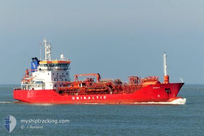
AMONITH
Oil/Chemical Tanker
Current Trip
| Time Travelled | 1 day |
|---|---|
| Remaining Time | --- |
| Distance Travelled | 267.96 nm |
| Remaining Distance | --- |
| AVG Speed | 10.4 Knots |
| MAX Speed | 11 Knots |
| AVG Wind | 7.9 knots |
| MAX Wind | 14.6 knots |
| MIN Temp | 12.1°C / 53.78°F |
| MAX Temp | 15°C / 59°F |
| Draught | 6.1 m |
| Position Received | 10 h, 12 m ago |
Current Position
| Longitude | 6.12547° |
|---|---|
| Latitude | 55.47084° |
| Status | Under way using engine |
| Speed | 10.7 Knots |
| Course | 204.7° |
| Area | North Sea |
| Station | T-AIS |
| Position Received | 10 h, 12 m ago |
Info
Information
The current position of AMONITH is in North Sea with coordinates 55.47084° / 6.12547° as reported on 2024-05-25 00:01 by AIS to our vessel tracker app. The vessel's current speed is 10.7 Knots and is heading at the port of FOYNES. The estimated time of arrival as calculated by vessel tracking app is 2024-05-28 17:00 LT
The vessel AMONITH (IMO: 9164093, MMSI: 210745000) is a Oil/Chemical Tanker that was built in 1999 ( 25 years old ). It's sailing under the flag of [CY] Cyprus.
In this page you can find informations about the vessels current position, last detected port calls, and current voyage information. If the vessels is not in coverage by AIS you will find the latest position.
The current position of AMONITH is detected by our AIS receivers and we are not responsible for the reliability of the data. The last position was recorded while the vessel was in Coverage by the Ais receivers of our vessel tracking app.
The current draught of AMONITH as reported by AIS is 6.1 meters
Weather
| Temperature | 13.7°C / 56.66°F |
|---|---|
| Wind Speed | 17 knots |
| Direction | 71° ENE |
| Pressure | 1017 hPa |
| Humidity | 93 % |
| Cloud Coverage | 100 % |
Featured Company
Last Port Calls
| Port | Arrival | Departure | Time In Port |
|---|---|---|---|
| 2024-05-23 06:26 | 2024-05-24 07:23 | 1 d | |
| 2024-05-19 23:48 | 2024-05-20 20:14 | 20 h | |
| 2024-05-13 22:33 | 2024-05-15 09:02 | 1 d | |
| 2024-05-08 20:36 | 2024-05-10 10:41 | 1 d | |
| 2024-04-26 12:24 | 2024-04-28 13:54 | 2 d | |
| 2024-04-21 04:40 | 2024-04-22 07:08 | 1 d | |
| 2024-04-15 15:23 | 2024-04-16 14:41 | 23 h | |
| 2024-04-12 14:14 | 2024-04-13 12:25 | 22 h | |
| 2024-04-07 19:49 | 2024-04-08 21:24 | 1 d | |
| 2024-04-03 16:16 | 2024-04-04 11:46 | 19 h |
Most Visited Ports (Last year)
| Port | Arrivals | |
|---|---|---|
| 30 | ||
| 25 | ||
| 21 | ||
| 8 | ||
| 6 | ||
| 5 |
Last Trips
| Origin | Departure | Destination | Arrival | Distance | |
|---|---|---|---|---|---|
| 2024-05-20 22:14 | 2024-05-23 08:26 | 534.56 nm | |||
| 2024-05-15 11:02 | 2024-05-20 01:48 | 683.08 nm | |||
| 2024-05-10 12:41 | 2024-05-14 00:33 | 430.16 nm | |||
| 2024-04-28 14:54 | 2024-05-08 22:36 | 990.43 nm | |||
| 2024-04-22 08:08 | 2024-04-26 13:24 | 803.54 nm | |||
| 2024-04-16 16:41 | 2024-04-21 05:40 | 1129.18 nm | |||
| 2024-04-13 14:25 | 2024-04-15 17:23 | 417.02 nm | |||
| 2024-04-08 23:24 | 2024-04-12 16:14 | 119.69 nm | |||
| 2024-04-04 13:46 | 2024-04-07 21:49 | 322.62 nm | |||
| 2024-04-03 08:50 | 2024-04-03 18:16 | 92.32 nm |
Events
| Time | Event | Details | Position / Dest | Info |
|---|---|---|---|---|
| 2024-05-25 00:03 | Status Changed | Default Under way using engine |
55.46638 / 6.12170
IE FOV
|
Speed: 10.7 kn Course: 204.7° |
| 2024-05-25 00:01 | Status Changed | Under way using engine Default |
55.47084 / 6.12547
IE FOV
|
Speed: 10.6 kn Course: 208° |
| 2024-05-25 00:01 | OUT of Coverage |
55.47084 / 6.12547
North Sea
IE FOV
|
Speed: 10.7 kn Course: 204.7° |
|
| 2024-05-24 23:47 | Status Changed | Default Under way using engine |
55.50834 / 6.15833
IE FOV
|
Speed: 10.7 kn Course: 207.8° |
| 2024-05-24 18:41 | Status Changed | Under way using engine Default |
56.32290 / 6.86271
IE FOV
|
Speed: 10 kn Course: 205° |
| 2024-05-24 18:23 | Status Changed | Default Under way using engine |
56.36833 / 6.90167
IE FOV
|
Speed: 10.3 kn Course: 206° |
| 2024-05-24 11:23 | Change Sea Area | Danish part of the North Sea Norwegian part of the North Sea |
57.46245 / 7.87117
North Sea
IE FOV
|
Speed: 10.3 kn Course: 205° |
| 2024-05-24 11:08 | Change Sea Area | Norwegian part of the North Sea Norwegian part of the Skaggerak |
57.50150 / 7.90457
North Sea
IE FOV
|
Speed: 10.1 kn Course: 203.7° |
| 2024-05-24 07:23 | PORT DEPARTURE |
|
58.12150 / 8.01554
IE FOV
|
Speed: 10.2 kn Course: 142° |
| 2024-05-24 07:12 | START Moving |
58.13685 / 7.97804
[NO] KRISTIANSAND
|
Speed: 3.4 kn Course: 105° |