
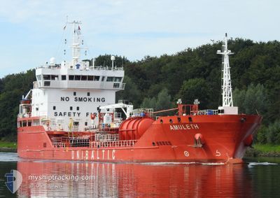
AMULETH
Tanker B
Current Trip
| Time Travelled | 2 days |
|---|---|
| Remaining Time | 1 day |
| Distance Travelled | 597.14 nm |
| Remaining Distance | 380.43 nm |
| AVG Speed | 11.1 Knots |
| MAX Speed | 12.2 Knots |
| AVG Wind | 15.2 knots |
| MAX Wind | 24.8 knots |
| MIN Temp | 13.7°C / 56.66°F |
| MAX Temp | 17.3°C / 63.14°F |
| Draught | 5.8 m |
| Position Received | 3 m ago |
Current Position
| Longitude | -4.51044° |
|---|---|
| Latitude | 49.20054° |
| Status | Under way using engine |
| Speed | 12.3 Knots |
| Course | 58.1° |
| Area | English Channel |
| Station | T-AIS |
| Position Received | 3 m ago |
Info
Information
The current position of AMULETH is in English Channel with coordinates 49.20054° / -4.51044° as reported on 2024-06-15 22:29 by AIS to our vessel tracker app. The vessel's current speed is 12.3 Knots and is heading at the port of ANTWERP. The estimated time of arrival as calculated by vessel tracking app is 2024-06-17 07:10 LT
The vessel AMULETH (IMO: 9778002, MMSI: 209066000) is a Tanker B It's sailing under the flag of [CY] Cyprus.
In this page you can find informations about the vessels current position, last detected port calls, and current voyage information. If the vessels is not in coverage by AIS you will find the latest position.
The current position of AMULETH is detected by our AIS receivers and we are not responsible for the reliability of the data. The last position was recorded while the vessel was in Coverage by the Ais receivers of our vessel tracking app.
The current draught of AMULETH as reported by AIS is 5.8 meters
Weather
| Temperature | 13.7°C / 56.66°F |
|---|---|
| Wind Speed | 18 knots |
| Direction | 255° WSW |
| Pressure | 1004.7 hPa |
| Humidity | 85.3 % |
| Cloud Coverage | 67 % |
Featured Company
Last Port Calls
| Port | Arrival | Departure | Time In Port |
|---|---|---|---|
| 2024-06-11 13:53 | 2024-06-13 16:52 | 2 d | |
| 2024-06-08 07:39 | 2024-06-09 11:18 | 1 d | |
| 2024-06-05 17:14 | 2024-06-07 01:34 | 1 d | |
| 2024-06-01 18:54 | 2024-06-03 12:51 | 1 d | |
| 2024-05-28 13:43 | 2024-05-29 17:28 | 1 d | |
| 2024-05-24 15:43 | 2024-05-25 17:14 | 1 d | |
| 2024-05-14 18:25 | 2024-05-18 21:45 | 4 d | |
| 2024-05-11 16:12 | 2024-05-12 08:56 | 16 h | |
| 2024-05-08 08:58 | 2024-05-10 07:50 | 1 d | |
| 2024-05-01 03:17 | 2024-05-05 21:55 | 4 d |
Most Visited Ports (Last year)
| Port | Arrivals | |
|---|---|---|
| 16 | ||
| 16 | ||
| 8 | ||
| 5 | ||
| 5 | ||
| 4 |
Last Trips
| Origin | Departure | Destination | Arrival | Distance | |
|---|---|---|---|---|---|
| 2024-06-09 12:18 | 2024-06-11 14:53 | 208.25 nm | |||
| 2024-06-07 03:34 | 2024-06-08 08:39 | 256.00 nm | |||
| 2024-06-03 13:51 | 2024-06-05 19:14 | 219.26 nm | |||
| 2024-05-29 19:28 | 2024-06-01 19:54 | 819.75 nm | |||
| 2024-05-25 19:14 | 2024-05-28 15:43 | 767.13 nm | |||
| 2024-05-18 23:45 | 2024-05-24 17:43 | 1425.66 nm | |||
| 2024-05-12 10:56 | 2024-05-14 20:25 | 388.72 nm | |||
| 2024-05-10 09:50 | 2024-05-11 18:12 | 247.11 nm | |||
| 2024-05-05 23:55 | 2024-05-08 10:58 | 287.37 nm | |||
| 2024-04-25 22:59 | 2024-05-01 05:17 | 550.51 nm |
Events
| Time | Event | Details | Position / Dest | Info |
|---|---|---|---|---|
| 2024-06-15 21:04 | Detected in Sea | French part of the English Channel |
49.05715 / -4.88609
English Channel
BE ANR
|
Speed: 11.9 kn Course: 59.1° |
| 2024-06-15 20:21 | Status Changed | Under way using engine Default |
48.98229 / -5.07092
BE ANR
|
Speed: 11.6 kn Course: 56° |
| 2024-06-15 19:32 | Status Changed | Default Under way using engine |
48.89426 / -5.27099
BE ANR
|
Speed: 11.7 kn Course: 48.5° |
| 2024-06-15 19:26 | Status Changed | Under way using engine Default |
48.88211 / -5.29183
BE ANR
|
Speed: 11.5 kn Course: 55° |
| 2024-06-15 19:01 | Status Changed | Default Under way using engine |
48.83415 / -5.38948
BE ANR
|
Speed: 11.7 kn Course: 57.7° |
| 2024-06-15 18:52 | Status Changed | Under way using engine Default |
48.81794 / -5.42845
BE ANR
|
Speed: 11.6 kn Course: 60° |
| 2024-06-15 18:42 | Status Changed | Default Under way using engine |
48.80028 / -5.47058
BE ANR
|
Speed: 11.4 kn Course: 57.5° |
| 2024-06-15 18:35 | Status Changed | Under way using engine Default |
48.78858 / -5.49941
BE ANR
|
Speed: 11.4 kn Course: 58° |
| 2024-06-15 18:27 | Status Changed | Default Under way using engine |
48.77528 / -5.53198
BE ANR
|
Speed: 10.9 kn Course: 58.2° |
| 2024-06-15 18:00 | Status Changed | Under way using engine Default |
48.72963 / -5.63375
BE ANR
|
Speed: 11 kn Course: 29° |