
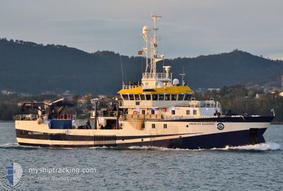
ANGELES ALVARINO
Research/Survey Vessel
Current Trip
RESEARCH OPS
| Time Travelled | 23 h, 10 mins |
|---|---|
| Remaining Time | --- |
| Distance Travelled | 79.97 nm |
| Remaining Distance | --- |
| AVG Speed | 9.4 Knots |
| MAX Speed | 10.9 Knots |
| AVG Wind | 12.9 knots |
| MAX Wind | 17 knots |
| MIN Temp | 9.4°C / 48.92°F |
| MAX Temp | 13.4°C / 56.12°F |
| Draught | 5.6 m |
| Position Received | 17 h, 46 m ago |
Current Position
| Longitude | -7.63089° |
|---|---|
| Latitude | 43.80093° |
| Status | Under way using engine |
| Speed | 8.3 Knots |
| Course | 112.2° |
| Area | Bay of Biscay |
| Station | T-AIS |
| Position Received | 17 h, 46 m ago |
Info
Information
The current position of ANGELES ALVARINO is in Bay of Biscay with coordinates 43.80093° / -7.63089° as reported on 2024-05-02 01:43 by AIS to our vessel tracker app. The vessel's current speed is 8.3 Knots
The vessel ANGELES ALVARINO (IMO: 9524645, MMSI: 225431000) is a Research/Survey Vessel that was built in 2012 ( 12 years old ). It's sailing under the flag of [ES] Spain.
In this page you can find informations about the vessels current position, last detected port calls, and current voyage information. If the vessels is not in coverage by AIS you will find the latest position.
The current position of ANGELES ALVARINO is detected by our AIS receivers and we are not responsible for the reliability of the data. The last position was recorded while the vessel was in Coverage by the Ais receivers of our vessel tracking app.
The current draught of ANGELES ALVARINO as reported by AIS is 5.6 meters
Weather
| Temperature | 12.4°C / 54.32°F |
|---|---|
| Wind Speed | 11 knots |
| Direction | 238° WSW |
| Pressure | 1015.1 hPa |
| Humidity | 73.1 % |
| Cloud Coverage | 100 % |
Featured Company
Last Port Calls
| Port | Arrival | Departure | Time In Port |
|---|---|---|---|
| 2024-04-28 08:26 | 2024-05-01 20:20 | 3 d | |
| 2024-04-27 12:30 | 2024-04-27 14:57 | 2 h | |
| 2024-04-25 05:25 | 2024-04-25 14:07 | 8 h | |
| 2024-04-22 07:16 | 2024-04-22 21:03 | 13 h | |
| 2024-04-16 19:03 | 2024-04-18 08:45 | 1 d | |
| 2024-04-11 19:14 | 2024-04-13 16:41 | 1 d | |
| 2024-04-08 12:16 | 2024-04-09 20:10 | 1 d | |
| 2024-04-05 19:21 | 2024-04-05 22:04 | 2 h | |
| 2024-03-30 17:22 | 2024-03-31 14:15 | 20 h | |
| 2024-03-29 07:55 |
Most Visited Ports (Last year)
| Port | Arrivals | |
|---|---|---|
| 5 | ||
| 5 | ||
| 4 | ||
| 4 | ||
| 3 | ||
| 3 |
Last Trips
| Origin | Departure | Destination | Arrival | Distance | |
|---|---|---|---|---|---|
| 2024-04-27 16:57 | 2024-04-28 10:26 | 142.46 nm | |||
| 2024-04-25 16:07 | 2024-04-27 14:30 | 248.74 nm | |||
| 2024-04-22 23:03 | 2024-04-25 07:25 | 292.75 nm | |||
| 2024-04-18 10:45 | 2024-04-22 09:16 | 415.27 nm | |||
| 2024-04-13 18:41 | 2024-04-16 21:03 | 439.03 nm | |||
| 2024-04-09 22:10 | 2024-04-11 21:14 | 170.10 nm | |||
| 2024-04-06 00:04 | 2024-04-08 14:16 | 176.92 nm | |||
| 2024-03-31 16:15 | 2024-04-05 21:21 | 463.98 nm | |||
| 2024-03-29 08:55 | 2024-03-30 18:22 | 328.24 nm |
Events
| Time | Event | Details | Position / Dest | Info |
|---|---|---|---|---|
| 2024-05-02 18:21 | START Moving | 6.25 nm, North East of BURELA |
43.72167 / -7.23833
RESEARCH OPS
|
Speed: 9 kn Course: 292° |
| 2024-05-02 17:30 | STOP Moving | 6.87 nm, East of BURELA |
43.69667 / -7.20167
RESEARCH OPS
|
Speed: Course: -1° |
| 2024-05-02 16:57 | START Moving | 4.8 nm, North East of BURELA |
43.71667 / -7.27833
RESEARCH OPS
|
Speed: 10 kn Course: 110° |
| 2024-05-02 01:54 | Status Changed | Default Under way using engine |
43.79333 / -7.60167
RESEARCH OPS
|
Speed: 8.3 kn Course: 112.2° |
| 2024-05-02 01:43 | OUT of Coverage |
43.80093 / -7.63089
Bay of Biscay
RESEARCH OPS
|
Speed: 8.3 kn Course: 112.2° |
|
| 2024-05-02 00:59 | Change Sea Area | Spanish part of the Bay of Biscay Spanish part of the North Atlantic Ocean |
43.81645 / -7.80633
Bay of Biscay
RESEARCH OPS
|
Speed: 10.5 kn Course: 93.1° |
| 2024-05-02 00:39 | Status Changed | Under way using engine Default |
43.81828 / -7.88574
RESEARCH OPS
|
Speed: 11 kn Course: 89° |
| 2024-05-02 00:30 | IN Coverage |
43.81832 / -7.88035
North Atlantic Ocean
RESEARCH OPS
|
Speed: 10.6 kn Course: 88.5° |
|
| 2024-05-01 23:37 | Status Changed | Default Under way using engine |
43.76854 / -8.11291
RESEARCH OPS
|
Speed: 10.2 kn Course: 61.9° |
| 2024-05-01 23:32 | OUT of Coverage |
43.76147 / -8.13043
North Atlantic Ocean
RESEARCH OPS
|
Speed: 10.2 kn Course: 61.9° |