
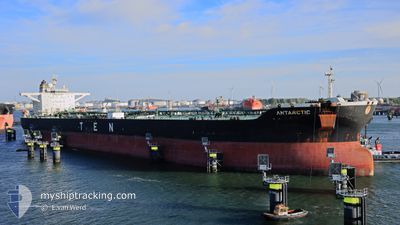
ANTARCTIC
Crude Oil Tanker
Current Trip
| Time Travelled | 10 days |
|---|---|
| Remaining Time | --- |
| Distance Travelled | 1764.53 nm |
| Remaining Distance | --- |
| AVG Speed | 12.4 Knots |
| MAX Speed | 15.7 Knots |
| AVG Wind | 9.9 knots |
| MAX Wind | 24.8 knots |
| MIN Temp | 10.2°C / 50.36°F |
| MAX Temp | 19.8°C / 67.64°F |
| Draught | 16.1 m |
| Position Received | 5 h, 13 m ago |
Current Position
| Longitude | -10.07163° |
|---|---|
| Latitude | 55.65198° |
| Status | Under way using engine |
| Speed | 12.7 Knots |
| Course | 209° |
| Area | North Atlantic Ocean |
| Station | T-AIS |
| Position Received | 5 h, 13 m ago |
Info
Information
The current position of ANTARCTIC is in North Atlantic Ocean with coordinates 55.65198° / -10.07163° as reported on 2024-06-02 13:34 by AIS to our vessel tracker app. The vessel's current speed is 12.7 Knots and is heading at the port of SINGAPORE. The estimated time of arrival as calculated by vessel tracking app is 2024-07-12 17:00 LT
The vessel ANTARCTIC (IMO: 9315185, MMSI: 636015560) is a Crude Oil Tanker that was built in 2007 ( 17 years old ). It's sailing under the flag of [LR] Liberia.
In this page you can find informations about the vessels current position, last detected port calls, and current voyage information. If the vessels is not in coverage by AIS you will find the latest position.
The current position of ANTARCTIC is detected by our AIS receivers and we are not responsible for the reliability of the data. The last position was recorded while the vessel was in Coverage by the Ais receivers of our vessel tracking app.
The current draught of ANTARCTIC as reported by AIS is 16.1 meters
Weather
| Temperature | 12.7°C / 54.86°F |
|---|---|
| Wind Speed | 18 knots |
| Direction | 263° W |
| Pressure | 1029.2 hPa |
| Humidity | 93 % |
| Cloud Coverage | 100 % |
Featured Company
Last Port Calls
| Port | Arrival | Departure | Time In Port |
|---|---|---|---|
| 2024-05-22 02:10 | 2024-05-23 14:04 | 1 d | |
| 2024-05-14 15:33 | 2024-05-16 02:06 | 1 d | |
| 2024-04-21 16:26 | 2024-04-23 13:02 | 1 d | |
| 2024-04-08 17:12 | 2024-04-11 00:20 | 2 d |
Last Trips
| Origin | Departure | Destination | Arrival | Distance | |
|---|---|---|---|---|---|
| 2024-05-16 04:06 | 2024-05-22 05:10 | 1334.65 nm | |||
| 2024-04-23 08:02 | 2024-05-14 17:33 | 5481.47 nm | |||
| 2024-04-10 19:20 | 2024-04-21 11:26 | 220.14 nm | |||
| 2024-03-26 23:49 | 2024-04-08 12:12 | 3010.48 nm |
Events
| Time | Event | Details | Position / Dest | Info |
|---|---|---|---|---|
| 2024-06-02 13:37 | Status Changed | Default Under way using engine |
55.64490 / -10.07878
GBSFW>>SGSIN
|
Speed: 12.7 kn Course: 209° |
| 2024-06-02 13:34 | OUT of Coverage |
55.65198 / -10.07163
North Atlantic Ocean
|
Speed: 12.7 kn Course: 209° |
|
| 2024-06-02 13:31 | Detected in Sea | Irish part of the North Atlantic Ocean |
55.66223 / -10.06148
North Atlantic Ocean
|
Speed: 12.8 kn Course: 208° |
| 2024-06-02 13:31 | Status Changed | Under way using engine Default |
55.66223 / -10.06148
GBSFW>>SGSIN
|
Speed: 12.8 kn Course: 207° |
| 2024-06-02 13:25 | IN Coverage |
55.66223 / -10.06148
North Atlantic Ocean
|
Speed: 12.8 kn Course: 208° |
|
| 2024-06-01 14:12 | Status Changed | Default Under way using engine |
58.74010 / -4.35563
GBSFW>>SGSIN
|
Speed: 9.1 kn Course: 263° |
| 2024-06-01 14:05 | OUT of Coverage |
58.74033 / -4.32310
North Atlantic Ocean
|
Speed: 9.1 kn Course: 263° |
|
| 2024-06-01 13:50 | Status Changed | Under way using engine Default |
58.74308 / -4.25027
GBSFW>>SGSIN
|
Speed: 9.2 kn Course: 268° |
| 2024-06-01 13:34 | Status Changed | Default Under way using engine |
58.74443 / -4.16955
GBSFW>>SGSIN
|
Speed: 9.3 kn Course: 271° |
| 2024-06-01 11:25 | Change Sea Area | United Kingdom part of the North Atlantic Ocean United Kingdom part of the North Sea |
58.75343 / -3.41443
North Atlantic Ocean
|
Speed: 14.1 kn Course: 268° |