
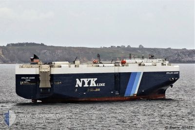
APOLLON LEADER
Vehicles Carrier
Current Trip
| Time Travelled | 19 days |
|---|---|
| Remaining Time | --- |
| Distance Travelled | 7980.22 nm |
| Remaining Distance | --- |
| AVG Speed | 16.4 Knots |
| MAX Speed | 21.2 Knots |
| AVG Wind | 12.5 knots |
| MAX Wind | 24.9 knots |
| MIN Temp | 16.1°C / 60.98°F |
| MAX Temp | 30.2°C / 86.36°F |
| Draught | 9.1 m |
| Position Received | 6 d ago |
Current Position
| Longitude | 17.04260° |
|---|---|
| Latitude | -33.55039° |
| Status | Under way using engine |
| Speed | 19.2 Knots |
| Course | 323.2° |
| Area | South Atlantic Ocean |
| Station | T-AIS |
| Position Received | 6 d ago |
Info
Information
The current position of APOLLON LEADER is in South Atlantic Ocean with coordinates -33.55039° / 17.04260° as reported on 2024-05-20 00:34 by AIS to our vessel tracker app. The vessel's current speed is 19.2 Knots and is heading at the port of GIBRALTAR. The estimated time of arrival as calculated by vessel tracking app is 2024-05-31 23:00 LT
The vessel APOLLON LEADER (IMO: 9402706, MMSI: 370508000) is a Vehicles Carrier that was built in 2008 ( 16 years old ). It's sailing under the flag of [PA] Panama.
In this page you can find informations about the vessels current position, last detected port calls, and current voyage information. If the vessels is not in coverage by AIS you will find the latest position.
The current position of APOLLON LEADER is detected by our AIS receivers and we are not responsible for the reliability of the data. The last position was recorded while the vessel was in Coverage by the Ais receivers of our vessel tracking app.
The current draught of APOLLON LEADER as reported by AIS is 9.1 meters
Weather
| Temperature | 26.8°C / 80.24°F |
|---|---|
| Wind Speed | 14 knots |
| Direction | 133° SE |
| Pressure | 1014.6 hPa |
| Humidity | 71 % |
| Cloud Coverage | 100 % |
Featured Company
Last Port Calls
| Port | Arrival | Departure | Time In Port |
|---|---|---|---|
| 2024-05-06 06:56 | 2024-05-06 14:36 | 7 h | |
| 2024-04-28 12:16 | 2024-04-29 08:24 | 20 h | |
| 2024-04-25 20:40 | 2024-04-26 08:16 | 11 h | |
| 2024-04-21 04:20 | 2024-04-24 06:44 | 3 d | |
| 2024-04-16 09:13 | 2024-04-16 22:23 | 13 h | |
| 2024-04-01 08:53 | 2024-04-01 22:17 | 13 h | |
| 2024-03-28 03:49 | 2024-03-31 06:58 | 3 d | |
| 2024-03-13 02:53 | 2024-03-14 11:40 | 1 d | |
| 2024-03-08 21:30 | 2024-03-09 09:34 | 12 h |
Most Visited Ports (Last year)
| Port | Arrivals | |
|---|---|---|
| 4 | ||
| 3 | ||
| 2 | ||
| 2 | ||
| 2 | ||
| 2 |
Last Trips
| Origin | Departure | Destination | Arrival | Distance | |
|---|---|---|---|---|---|
| 2024-04-29 17:24 | 2024-05-06 14:56 | 2678.59 nm | |||
| 2024-04-26 17:16 | 2024-04-28 21:16 | 875.26 nm | |||
| 2024-04-24 15:44 | 2024-04-26 05:40 | 455.12 nm | |||
| 2024-04-17 06:23 | 2024-04-21 13:20 | 1025.40 nm | |||
| 2024-04-01 15:17 | 2024-04-16 17:13 | 5824.62 nm | |||
| 2024-03-30 23:58 | 2024-04-01 01:53 | 400.82 nm | |||
| 2024-03-14 20:40 | 2024-03-27 20:49 | 4783.00 nm | |||
| 2024-03-09 18:34 | 2024-03-13 11:53 | 1331.09 nm | |||
| 2024-02-22 03:37 | 2024-03-09 06:30 | 5315.45 nm |
Events
| Time | Event | Details | Position / Dest | Info |
|---|---|---|---|---|
| 2024-05-20 00:39 | Status Changed | Default Under way using engine |
-33.52818 / 17.02289
GI GIB
|
Speed: 19.2 kn Course: 323.2° |
| 2024-05-20 00:34 | OUT of Coverage |
-33.55039 / 17.04260
South Atlantic Ocean
GI GIB
|
Speed: 19.2 kn Course: 323.2° |
|
| 2024-05-20 00:34 | Status Changed | Under way using engine Default |
-33.55118 / 17.04330
GI GIB
|
Speed: 19.2 kn Course: 323° |
| 2024-05-20 00:11 | Status Changed | Default Under way using engine |
-33.65180 / 17.12952
GI GIB
|
Speed: 19.1 kn Course: 325.3° |
| 2024-05-20 00:05 | Status Changed | Under way using engine Default |
-33.67556 / 17.14923
GI GIB
|
Speed: 19 kn Course: 325° |
| 2024-05-19 23:46 | IN Coverage |
-33.67380 / 17.14777
South Atlantic Ocean
GI GIB
|
Speed: 19.1 kn Course: 325.3° |
|
| 2024-05-19 20:55 | Status Changed | Default Under way using engine |
-34.44833 / 17.89167
GI GIB
|
Speed: 18.8 kn Course: 320.5° |
| 2024-05-19 20:51 | OUT of Coverage |
-34.46808 / 17.91140
South Atlantic Ocean
GI GIB
|
Speed: 18.8 kn Course: 320.5° |
|
| 2024-05-19 19:35 | ETA Changed | 2024/05/31 23:00 2024/05/31 16:00 |
-34.70815 / 18.27333
GI GIB
|
Speed: 18.1 kn Course: 285.7° |
| 2024-05-19 18:47 | Status Changed | Under way using engine Default |
-34.77887 / 18.55255
GI GIB
|
Speed: 18 kn Course: 289° |