
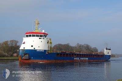
ARAMIS
Cargo
Current Trip
| Time Travelled | 6 days |
|---|---|
| Remaining Time | --- |
| Distance Travelled | 1527.71 nm |
| Remaining Distance | --- |
| AVG Speed | 10.7 Knots |
| MAX Speed | 12.6 Knots |
| AVG Wind | 12 knots |
| MAX Wind | 27.1 knots |
| MIN Temp | 15.1°C / 59.18°F |
| MAX Temp | 23.2°C / 73.76°F |
| Draught | 5.1 m |
| Position Received | 2 h, 28 m ago |
Current Position
| Longitude | 11.21471° |
|---|---|
| Latitude | 37.55435° |
| Status | Under way using engine |
| Speed | 12.1 Knots |
| Course | 94.3° |
| Area | Mediterranean Sea - Western Basin |
| Station | T-AIS |
| Position Received | 2 h, 28 m ago |
Info
Information
The current position of ARAMIS is in Mediterranean Sea - Western Basin with coordinates 37.55435° / 11.21471° as reported on 2024-06-09 23:41 by AIS to our vessel tracker app. The vessel's current speed is 12.1 Knots and is heading at the port of LAVRIO. The estimated time of arrival as calculated by vessel tracking app is 2024-06-12 19:00 LT
The vessel ARAMIS (IMO: 9815329, MMSI: 244170427) is a Cargo It's sailing under the flag of [NL] Netherlands.
In this page you can find informations about the vessels current position, last detected port calls, and current voyage information. If the vessels is not in coverage by AIS you will find the latest position.
The current position of ARAMIS is detected by our AIS receivers and we are not responsible for the reliability of the data. The last position was recorded while the vessel was in Coverage by the Ais receivers of our vessel tracking app.
The current draught of ARAMIS as reported by AIS is 5.1 meters
Weather
| Temperature | 21.3°C / 70.34°F |
|---|---|
| Wind Speed | 8 knots |
| Direction | 310° NW |
| Pressure | 1010.4 hPa |
| Humidity | 84.7 % |
| Cloud Coverage | 100 % |
Featured Company
Last Port Calls
| Port | Arrival | Departure | Time In Port |
|---|---|---|---|
| 2024-06-01 16:24 | 2024-06-03 20:37 | 2 d | |
| 2024-05-30 17:12 | 2024-05-31 18:38 | 1 d | |
| 2024-05-26 07:07 | 2024-05-26 19:14 | 12 h | |
| 2024-05-19 10:25 | 2024-05-19 14:13 | 3 h | |
| 2024-05-16 08:39 | 2024-05-18 18:10 | 2 d | |
| 2024-05-04 09:14 | 2024-05-06 18:22 | 2 d | |
| 2024-04-27 11:46 | 2024-04-28 19:08 | 1 d | |
| 2024-04-24 11:15 | 2024-04-25 12:44 | 1 d | |
| 2024-04-16 23:37 | 2024-04-17 19:31 | 19 h | |
| 2024-04-15 16:15 | 2024-04-16 19:44 | 1 d |
Last Trips
| Origin | Departure | Destination | Arrival | Distance | |
|---|---|---|---|---|---|
| 2024-05-31 20:38 | 2024-06-01 18:24 | 254.17 nm | |||
| 2024-05-26 20:14 | 2024-05-30 19:12 | 1047.04 nm | |||
| 2024-05-19 16:13 | 2024-05-26 08:07 | 1645.35 nm | |||
| 2024-05-18 20:10 | 2024-05-19 12:25 | 110.52 nm | |||
| 2024-05-06 20:22 | 2024-05-16 10:39 | 1149.92 nm | |||
| 2024-04-28 21:08 | 2024-05-04 11:14 | 504.46 nm | |||
| 2024-04-25 14:44 | 2024-04-27 13:46 | 515.97 nm | |||
| 2024-04-17 21:31 | 2024-04-24 13:15 | 500.25 nm | |||
| 2024-04-16 21:44 | 2024-04-17 01:37 | 34.61 nm | |||
| 2024-04-05 13:09 | 2024-04-15 18:15 | 2092.59 nm |
Events
| Time | Event | Details | Position / Dest | Info |
|---|---|---|---|---|
| 2024-06-09 23:47 | Status Changed | Default Under way using engine |
37.55167 / 11.23833
GR LAV
|
Speed: 12.1 kn Course: 94.3° |
| 2024-06-09 23:41 | OUT of Coverage |
37.55435 / 11.21471
Mediterranean Sea - Western Basin
GR LAV
|
Speed: 12.1 kn Course: 94.3° |
|
| 2024-06-09 23:39 | Status Changed | Under way using engine Default |
37.55502 / 11.20398
GR LAV
|
Speed: 12 kn Course: 94° |
| 2024-06-09 23:23 | Status Changed | Default Under way using engine |
37.55833 / 11.13667
GR LAV
|
Speed: 12.1 kn Course: 94.7° |
| 2024-06-09 23:13 | Status Changed | Under way using engine Default |
37.56242 / 11.09447
GR LAV
|
Speed: 11 kn Course: 93° |
| 2024-06-09 23:02 | Status Changed | Default Under way using engine |
37.56333 / 11.04833
GR LAV
|
Speed: 11.8 kn Course: 93.4° |
| 2024-06-09 21:56 | ETA Changed | 2024/06/12 19:00 2024/06/12 20:00 |
37.55613 / 10.78207
GR LAV
|
Speed: 11 kn Course: 91.6° |
| 2024-06-09 21:52 | Status Changed | Under way using engine Default |
37.55630 / 10.76767
GR LAV
|
Speed: 11 kn Course: 90° |
| 2024-06-09 21:47 | Status Changed | Default Under way using engine |
37.55500 / 10.74833
GR LAV
|
Speed: 11.2 kn Course: 90.6° |
| 2024-06-09 21:43 | Change Sea Area | Tunisian part of the Mediterranean Sea - Western Basin Spanish part of the Alboran Sea |
37.55666 / 10.73304
Mediterranean Sea - Western Basin
GR LAV
|
Speed: 11.2 kn Course: 90.6° |