
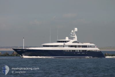
ARCHIMEDES
Yacht
Current Trip
WEST PALM BEACH
| Time Travelled | 1 day |
|---|---|
| Remaining Time | --- |
| Distance Travelled | 12.97 nm |
| Remaining Distance | --- |
| AVG Speed | 15.3 Knots |
| MAX Speed | 16.3 Knots |
| AVG Wind | 16.4 knots |
| MAX Wind | 17 knots |
| MIN Temp | 26.5°C / 79.7°F |
| MAX Temp | 26.5°C / 79.7°F |
| Draught | 3.5 m |
| Position Received | 1 d ago |
Current Position
| Longitude | -79.95283° |
|---|---|
| Latitude | 27.25303° |
| Status | Under way using engine |
| Speed | 15.7 Knots |
| Course | --- |
| Area | North Atlantic Ocean |
| Station | T-AIS |
| Position Received | 1 d ago |
Info
Information
The current position of ARCHIMEDES is in North Atlantic Ocean with coordinates 27.25303° / -79.95283° as reported on 2024-06-01 11:39 by AIS to our vessel tracker app. The vessel's current speed is 15.7 Knots
The vessel ARCHIMEDES (IMO: 1009637, MMSI: 310563000) is a Yacht that was built in 2008 ( 16 years old ). It's sailing under the flag of [BM] Bermuda.
In this page you can find informations about the vessels current position, last detected port calls, and current voyage information. If the vessels is not in coverage by AIS you will find the latest position.
The current position of ARCHIMEDES is detected by our AIS receivers and we are not responsible for the reliability of the data. The last position was recorded while the vessel was in Coverage by the Ais receivers of our vessel tracking app.
The current draught of ARCHIMEDES as reported by AIS is 3.5 meters
Weather
| Temperature | 26°C / 78.8°F |
|---|---|
| Wind Speed | 18 knots |
| Direction | 69° ENE |
| Pressure | 1019.2 hPa |
| Humidity | 65.2 % |
| Cloud Coverage | 100 % |
Featured Company
Last Port Calls
| Port | Arrival | Departure | Time In Port |
|---|---|---|---|
| 2024-06-01 09:41 |
Last Trips
| Origin | Departure | Destination | Arrival | Distance |
|---|
Events
| Time | Event | Details | Position / Dest | Info |
|---|---|---|---|---|
| 2024-06-01 11:39 | OUT of Coverage |
27.25303 / -79.95283
North Atlantic Ocean
|
Speed: 15.7 kn Course: 0° |
|
| 2024-06-01 10:46 | Draught Changed | 3.5 3 |
27.02758 / -79.96287
WEST PALM BEACH
|
Speed: 15.3 kn Course: 4.8° |
| 2024-06-01 10:46 | ETA Changed | 2025/03/31 15:00 |
27.02758 / -79.96287
WEST PALM BEACH
|
Speed: 15.3 kn Course: 4.8° |
| 2024-06-01 10:08 | IN Coverage |
26.87696 / -79.97037
North Atlantic Ocean
|
Speed: 16.1 kn Course: 354.8° |
|
| 2024-06-01 09:41 | PORT DEPARTURE |
|
26.86427 / -79.96940
WEST PALM BEACH
|
Speed: Course: 92° |
| 2024-05-31 14:42 | OUT of Coverage |
26.77877 / -80.05020
North Atlantic Ocean
[US] PALM BEACH
|
Speed: Course: 92° |
|
| 2024-05-31 11:57 | IN Coverage |
26.77878 / -80.05021
North Atlantic Ocean
[US] PALM BEACH
|
Speed: Course: 92° |
|
| 2024-05-30 12:46 | OUT of Coverage |
26.77876 / -80.05021
North Atlantic Ocean
[US] PALM BEACH
|
Speed: Course: 92° |
|
| 2024-05-30 12:46 | IN Coverage |
26.77876 / -80.05021
North Atlantic Ocean
[US] PALM BEACH
|
Speed: Course: 92° |
|
| 2024-05-29 11:58 | OUT of Coverage |
26.77876 / -80.05021
North Atlantic Ocean
[US] PALM BEACH
|
Speed: Course: 92° |