
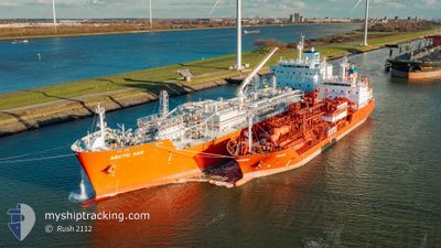
ARCTIC GAS
Tanker
Current Trip
| Time Travelled | 4 h, 6 mins |
|---|---|
| Remaining Time | --- |
| Distance Travelled | 31.10 nm |
| Remaining Distance | --- |
| AVG Speed | 11.4 Knots |
| MAX Speed | 13.8 Knots |
| AVG Wind | 10.1 knots |
| MAX Wind | 11.9 knots |
| MIN Temp | 29.1°C / 84.38°F |
| MAX Temp | 30.9°C / 87.62°F |
| Draught | 7.7 m |
| Position Received | 3 h, 14 m ago |
Current Position
| Longitude | -94.83729° |
|---|---|
| Latitude | 29.43824° |
| Status | Under way using engine |
| Speed | 12.7 Knots |
| Course | 156.2° |
| Area | Gulf of Mexico |
| Station | T-AIS |
| Position Received | 3 h, 14 m ago |
Info
Information
The current position of ARCTIC GAS is in Gulf of Mexico with coordinates 29.43824° / -94.83729° as reported on 2024-06-16 16:50 by AIS to our vessel tracker app. The vessel's current speed is 12.7 Knots
The vessel ARCTIC GAS (IMO: 9745512, MMSI: 219025000) is a Tanker It's sailing under the flag of [DK] Denmark.
In this page you can find informations about the vessels current position, last detected port calls, and current voyage information. If the vessels is not in coverage by AIS you will find the latest position.
The current position of ARCTIC GAS is detected by our AIS receivers and we are not responsible for the reliability of the data. The last position was recorded while the vessel was in Coverage by the Ais receivers of our vessel tracking app.
The current draught of ARCTIC GAS as reported by AIS is 7.7 meters
Weather
| Temperature | 29.3°C / 84.74°F |
|---|---|
| Wind Speed | 12 knots |
| Direction | 112° ESE |
| Pressure | 1011.3 hPa |
| Humidity | 70.9 % |
| Cloud Coverage | --- |
Featured Company
Last Port Calls
| Port | Arrival | Departure | Time In Port |
|---|---|---|---|
| 2024-06-12 04:19 | 2024-06-16 15:59 | 4 d | |
| 2024-05-18 05:23 | 2024-05-28 03:03 | 9 d | |
| 2024-05-13 13:00 | 2024-05-16 10:34 | 2 d |
Most Visited Ports (Last year)
| Port | Arrivals | |
|---|---|---|
| 4 | ||
| 2 | ||
| 1 | ||
| 1 | ||
| 1 | ||
| 1 |
Last Trips
| Origin | Departure | Destination | Arrival | Distance | |
|---|---|---|---|---|---|
| 2024-05-28 05:03 | 2024-06-11 23:19 | 5118.17 nm | |||
| 2024-05-16 12:34 | 2024-05-18 07:23 | 105.35 nm |
Events
| Time | Event | Details | Position / Dest | Info |
|---|---|---|---|---|
| 2024-06-16 18:51 | STOP Moving | 7.99 nm, South East of GALVESTON |
29.22616 / -94.67687
GALVESTON ANCH
|
Speed: 0.3 kn Course: 123° |
| 2024-06-16 16:55 | Status Changed | Default Under way using engine |
29.42134 / -94.82893
GALVESTON ANCH
|
Speed: 12.7 kn Course: 156.2° |
| 2024-06-16 16:50 | OUT of Coverage |
29.43824 / -94.83729
Gulf of Mexico
GALVESTON ANCH
|
Speed: 12.7 kn Course: 156.2° |
|
| 2024-06-16 15:59 | PORT DEPARTURE |
|
29.59084 / -94.93970
GALVESTON ANCH
|
Speed: 10 kn Course: 144° |
| 2024-06-16 14:43 | Status Changed | Under way using engine Default |
29.76378 / -95.08494
[US] HOUSTON
|
Speed: 8.2 kn Course: 31° |
| 2024-06-16 14:39 | Status Changed | Default Under way using engine |
29.75812 / -95.09165
[US] HOUSTON
|
Speed: 7.4 kn Course: 45° |
| 2024-06-16 14:26 | Status Changed | Under way using engine Default |
29.73929 / -95.11444
[US] HOUSTON
|
Speed: 6.2 kn Course: 67° |
| 2024-06-16 14:23 | Status Changed | Default Under way using engine |
29.73788 / -95.11835
[US] HOUSTON
|
Speed: 7.3 kn Course: 80° |
| 2024-06-16 13:44 | Status Changed | Under way using engine Default |
29.74150 / -95.19902
[US] HOUSTON
|
Speed: 7.7 kn Course: 54° |
| 2024-06-16 13:43 | Status Changed | Default Under way using engine |
29.74021 / -95.20105
[US] HOUSTON
|
Speed: 7.1 kn Course: 28° |