
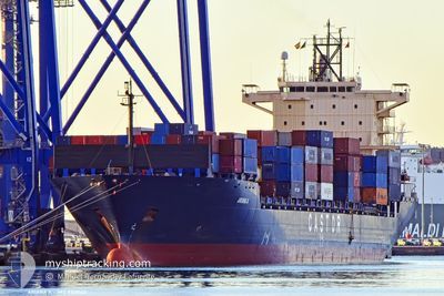
ARIANA A
Container Ship
Current Trip
| Time Travelled | 1 day |
|---|---|
| Remaining Time | 1 day |
| Distance Travelled | 584.83 nm |
| Remaining Distance | 599.30 nm |
| AVG Speed | 17.8 Knots |
| MAX Speed | 18.8 Knots |
| AVG Wind | 6.2 knots |
| MAX Wind | 21.1 knots |
| MIN Temp | 17.7°C / 63.86°F |
| MAX Temp | 21.3°C / 70.34°F |
| Draught | 10.2 m |
| Position Received | Now |
Current Position
| Longitude | 13.09109° |
|---|---|
| Latitude | 36.71760° |
| Status | Under way using engine |
| Speed | 17.5 Knots |
| Course | 113.8° |
| Area | Mediterranean Sea - Eastern Basin |
| Station | T-AIS |
| Position Received | Now |
Info
Information
The current position of ARIANA A is in Mediterranean Sea - Eastern Basin with coordinates 36.71760° / 13.09109° as reported on 2024-05-22 16:44 by AIS to our vessel tracker app. The vessel's current speed is 17.5 Knots and is heading at the port of PIRAEUS. The estimated time of arrival as calculated by vessel tracking app is 2024-05-24 02:18 LT
The vessel ARIANA A (IMO: 9320142, MMSI: 538009388) is a Container Ship that was built in 2005 ( 19 years old ). It's sailing under the flag of [MH] Marshall Is.
In this page you can find informations about the vessels current position, last detected port calls, and current voyage information. If the vessels is not in coverage by AIS you will find the latest position.
The current position of ARIANA A is detected by our AIS receivers and we are not responsible for the reliability of the data. The last position was recorded while the vessel was in Coverage by the Ais receivers of our vessel tracking app.
The current draught of ARIANA A as reported by AIS is 10.2 meters
Weather
| Temperature | 20.9°C / 69.62°F |
|---|---|
| Wind Speed | 5 knots |
| Direction | 269° W |
| Pressure | 1016.9 hPa |
| Humidity | 69.1 % |
| Cloud Coverage | --- |
Featured Company
Last Port Calls
| Port | Arrival | Departure | Time In Port |
|---|---|---|---|
| 2024-05-20 10:55 | 2024-05-21 07:54 | 20 h | |
| 2024-05-18 18:31 | 2024-05-19 21:32 | 1 d | |
| 2024-05-16 23:22 | 2024-05-18 14:59 | 1 d | |
| 2024-05-15 10:44 | 2024-05-16 02:13 | 15 h | |
| 2024-05-11 03:54 | 2024-05-11 19:30 | 15 h | |
| 2024-05-09 16:27 | 2024-05-10 05:35 | 13 h | |
| 2024-05-08 12:55 | 2024-05-09 10:07 | 21 h | |
| 2024-05-04 14:14 | 2024-05-07 10:06 | 2 d | |
| 2024-04-27 10:08 | 2024-04-28 07:10 | 21 h | |
| 2024-04-26 05:12 | 2024-04-27 01:04 | 19 h |
Last Trips
| Origin | Departure | Destination | Arrival | Distance | |
|---|---|---|---|---|---|
| 2024-05-19 23:32 | 2024-05-20 12:55 | 155.25 nm | |||
| 2024-05-18 16:59 | 2024-05-18 20:31 | 45.59 nm | |||
| 2024-05-16 04:13 | 2024-05-17 01:22 | 349.80 nm | |||
| 2024-05-11 22:30 | 2024-05-15 12:44 | 1333.74 nm | |||
| 2024-05-10 08:35 | 2024-05-11 06:54 | 291.75 nm | |||
| 2024-05-09 13:07 | 2024-05-09 19:27 | 47.97 nm | |||
| 2024-05-07 13:06 | 2024-05-08 15:55 | 366.39 nm | |||
| 2024-04-28 09:10 | 2024-05-04 17:14 | 1296.00 nm | |||
| 2024-04-27 03:04 | 2024-04-27 12:08 | 134.57 nm | |||
| 2024-04-26 03:30 | 2024-04-26 07:12 | 47.54 nm |
Events
| Time | Event | Details | Position / Dest | Info |
|---|---|---|---|---|
| 2024-05-22 13:32 | Change Sea Area | Italian part of the Mediterranean Sea - Eastern Basin Tunisian part of the Mediterranean Sea - Eastern Basin |
37.06418 / 11.99333
Mediterranean Sea - Eastern Basin
PIRAEUS
|
Speed: 17.2 kn Course: 110.7° |
| 2024-05-22 13:11 | ETA Changed | 2024/05/24 05:00 2024/05/24 07:00 |
37.10401 / 11.87223
PIRAEUS
|
Speed: 17.9 kn Course: 112.8° |
| 2024-05-22 12:11 | Status Changed | Under way using engine Default |
37.22318 / 11.53807
PIRAEUS
|
Speed: 17.5 kn Course: 107° |
| 2024-05-22 12:05 | Status Changed | Default Under way using engine |
37.23186 / 11.50438
PIRAEUS
|
Speed: 17.3 kn Course: 108.9° |
| 2024-05-22 11:52 | Change Sea Area | Tunisian part of the Mediterranean Sea - Eastern Basin Tunisian part of the Mediterranean Sea - Western Basin |
37.25296 / 11.43074
Mediterranean Sea - Eastern Basin
PIRAEUS
|
Speed: 17.4 kn Course: 110.1° |
| 2024-05-22 11:51 | Status Changed | Under way using engine Default |
37.25514 / 11.42330
PIRAEUS
|
Speed: 17.3 kn Course: 111° |
| 2024-05-22 11:24 | Status Changed | Default Under way using engine |
37.30859 / 11.27375
PIRAEUS
|
Speed: 17.7 kn Course: 121.5° |
| 2024-05-22 08:10 | Status Changed | Under way using engine Default |
37.55653 / 10.09487
PIRAEUS
|
Speed: 18.6 kn Course: 85° |
| 2024-05-22 07:55 | Status Changed | Default Under way using engine |
37.55030 / 9.99328
PIRAEUS
|
Speed: 18.5 kn Course: 90.4° |
| 2024-05-22 07:24 | Status Changed | Under way using engine Default |
37.55972 / 9.79745
PIRAEUS
|
Speed: 18.4 kn Course: 131° |