
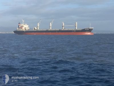
ASAHI OCEAN
Bulk Carrier
Current Trip
| Trip Time | 42 days |
|---|---|
| Trip Distance | 3317.14 nm |
| AVG Speed | 8.6 Knots |
| MAX Speed | 12.1 Knots |
| Draught | 9.9 m |
| AVG Wind | 9.8 knots |
| MAX Wind | 29.8 knots |
| MIN Temp | 9.9°C / 49.82°F |
| MAX Temp | 31.1°C / 87.98°F |
| Position Received | 2 h, 32 m ago |
Current Position
| Longitude | -122.21747° |
|---|---|
| Latitude | 38.05819° |
| Status | Under way using engine |
| Speed | 0.9 Knots |
| Course | 92° |
| Area | North Pacific Ocean |
| Station | T-AIS |
| Position Received | 2 h, 32 m ago |
Info
Information
The current position of ASAHI OCEAN is in North Pacific Ocean with coordinates 38.05819° / -122.21747° as reported on 2024-06-26 14:25 by AIS to our vessel tracker app. The vessel's current speed is 0.9 Knots and is currently inside the port of CROCKETT.
The vessel ASAHI OCEAN (IMO: 9597408, MMSI: 357994000) is a Bulk Carrier that was built in 2013 ( 11 years old ). It's sailing under the flag of [PA] Panama.
In this page you can find informations about the vessels current position, last detected port calls, and current voyage information. If the vessels is not in coverage by AIS you will find the latest position.
The current position of ASAHI OCEAN is detected by our AIS receivers and we are not responsible for the reliability of the data. The last position was recorded while the vessel was in Coverage by the Ais receivers of our vessel tracking app.
The current draught of ASAHI OCEAN as reported by AIS is 9.9 meters
Weather
| Temperature | 15.9°C / 60.62°F |
|---|---|
| Wind Speed | 7 knots |
| Direction | 214° SW |
| Pressure | 1016 hPa |
| Humidity | 67.5 % |
| Cloud Coverage | 10 % |
Featured Company
Last Port Calls
| Port | Arrival | Departure | Time In Port |
|---|---|---|---|
| 2024-06-26 14:23 | |||
| 2024-05-07 22:40 | 2024-05-15 12:17 | 7 d | |
| 2024-04-25 16:33 | 2024-04-27 13:43 | 1 d |
Last Trips
| Origin | Departure | Destination | Arrival | Distance | |
|---|---|---|---|---|---|
| 2024-05-15 06:17 | 2024-06-26 07:23 | 3317.14 nm | |||
| 2024-04-27 07:43 | 2024-05-07 16:40 | 391.91 nm |
Events
| Time | Event | Details | Position / Dest | Info |
|---|---|---|---|---|
| 2024-06-26 14:32 | Status Changed | Default Under way using engine |
38.05783 / -122.21677
[US] CROCKETT
|
Speed: 0.9 kn Course: 92° |
| 2024-06-26 14:32 | STOP Moving |
38.05783 / -122.21677
[US] CROCKETT
|
Speed: 0.1 kn Course: 95° |
|
| 2024-06-26 14:25 | Status Changed | Under way using engine Default |
38.05819 / -122.21747
[US] CROCKETT
|
Speed: 1.4 kn Course: 93° |
| 2024-06-26 14:25 | OUT of Coverage |
38.05819 / -122.21747
North Pacific Ocean
[US] CROCKETT
|
Speed: 0.9 kn Course: 113.4° |
|
| 2024-06-26 14:23 | PORT ARRIVAL |
|
38.05828 / -122.21787
[US] CROCKETT
|
Speed: 3 kn Course: 91° |
| 2024-06-26 14:12 | Status Changed | Default Under way using engine |
38.05971 / -122.22881
US CRM
|
Speed: 6.7 kn Course: 99.3° |
| 2024-06-26 11:03 | START Moving | 3.08 nm, South East of SAN FRANCISCO |
37.73116 / -122.33728
US CRM
|
Speed: 3.8 kn Course: 335° |
| 2024-06-26 10:41 | Status Changed | Under way using engine At anchor |
37.72691 / -122.33433
US CRM
|
Speed: 0.4 kn Course: 322° |
| 2024-06-25 21:37 | ETA Changed | 2024/06/26 14:00 2024/06/26 03:00 |
37.72615 / -122.33471
US CRM
|
Speed: Course: 327° |
| 2024-06-25 21:08 | Destination Changed | US CRM US CROCKETT |
37.72614 / -122.33495
US CRM
|
Speed: Course: 331° |