
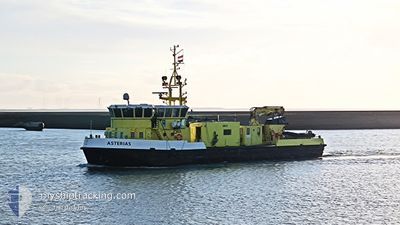
ASTERIAS
Research/Survey Vessel
Current Trip
| Trip Time | 6 h, 0 mins |
|---|---|
| Trip Distance | 21.91 nm |
| AVG Speed | 7.1 Knots |
| MAX Speed | 11.6 Knots |
| Draught | 1.2 m |
| AVG Wind | 9.5 knots |
| MAX Wind | 10.9 knots |
| MIN Temp | 13.8°C / 56.84°F |
| MAX Temp | 15.6°C / 60.08°F |
| Position Received | 2 m ago |
Current Position
| Longitude | 5.41463° |
|---|---|
| Latitude | 53.17848° |
| Status | Moored |
| Speed | |
| Course | 76° |
| Area | North Sea |
| Station | T-AIS |
| Position Received | 2 m ago |
Info
Information
The current position of ASTERIAS is in North Sea with coordinates 53.17848° / 5.41463° as reported on 2024-06-02 22:07 by AIS to our vessel tracker app. The vessel's current speed is 0 Knots and is currently inside the port of HARLINGEN.
The vessel ASTERIAS (IMO: 8943545, MMSI: 246017000) is a Research/Survey Vessel that was built in 1998 ( 26 years old ). It's sailing under the flag of [NL] Netherlands.
In this page you can find informations about the vessels current position, last detected port calls, and current voyage information. If the vessels is not in coverage by AIS you will find the latest position.
The current position of ASTERIAS is detected by our AIS receivers and we are not responsible for the reliability of the data. The last position was recorded while the vessel was in Coverage by the Ais receivers of our vessel tracking app.
The current draught of ASTERIAS as reported by AIS is 1.2 meters
Weather
| Temperature | 12.9°C / 55.22°F |
|---|---|
| Wind Speed | 11 knots |
| Direction | 338° NNW |
| Pressure | 1022 hPa |
| Humidity | 76.1 % |
| Cloud Coverage | 97 % |
Featured Company
Last Port Calls
| Port | Arrival | Departure | Time In Port |
|---|---|---|---|
| 2024-05-31 10:28 | |||
| 2024-05-29 14:24 | 2024-05-31 04:28 | 1 d | |
| 2024-05-28 12:04 | 2024-05-29 05:34 | 17 h | |
| 2024-05-27 13:26 | 2024-05-28 06:09 | 16 h | |
| 2024-05-24 12:19 | 2024-05-27 06:11 | 2 d | |
| 2024-05-23 11:33 | 2024-05-24 06:14 | 18 h | |
| 2024-05-21 13:11 | 2024-05-23 06:14 | 1 d | |
| 2024-05-16 09:42 | 2024-05-21 05:36 | 4 d | |
| 2024-05-13 12:51 | 2024-05-14 07:13 | 18 h | |
| 2024-05-11 15:24 | 2024-05-13 06:17 | 1 d |
Most Visited Ports (Last year)
| Port | Arrivals | |
|---|---|---|
| 144 | ||
| 3 | ||
| 1 | ||
| 1 |
Last Trips
| Origin | Departure | Destination | Arrival | Distance | |
|---|---|---|---|---|---|
| 2024-05-31 06:28 | 2024-05-31 12:28 | 21.91 nm | |||
| 2024-05-29 07:34 | 2024-05-29 16:24 | 49.03 nm | |||
| 2024-05-28 08:09 | 2024-05-28 14:04 | 39.63 nm | |||
| 2024-05-27 08:11 | 2024-05-27 15:26 | 44.50 nm | |||
| 2024-05-24 08:14 | 2024-05-24 14:19 | 14.10 nm | |||
| 2024-05-23 08:14 | 2024-05-23 13:33 | 41.91 nm | |||
| 2024-05-21 07:36 | 2024-05-21 15:11 | 49.92 nm | |||
| 2024-05-14 09:13 | 2024-05-16 11:42 | 174.46 nm | |||
| 2024-05-13 08:17 | 2024-05-13 14:51 | 28.02 nm | |||
| 2024-05-11 09:06 | 2024-05-11 17:24 | 25.84 nm |
Events
| Time | Event | Details | Position / Dest | Info |
|---|---|---|---|---|
| 2024-06-02 00:25 | Status Changed | Moored Default |
53.17847 / 5.41463
[NL] HARLINGEN
|
Speed: Course: -1° |
| 2024-06-02 00:19 | Status Changed | Default Moored |
53.17833 / 5.41333
[NL] HARLINGEN
|
Speed: Course: 76° |
| 2024-06-01 00:00 | ETA Changed | 2025/05/15 16:00 2024/05/15 16:00 |
53.17848 / 5.41461
[NL] HARLINGEN
|
Speed: Course: 76° |
| 2024-05-31 10:31 | Status Changed | Moored Under way using engine |
53.17846 / 5.41463
[NL] HARLINGEN
|
Speed: Course: 77° |
| 2024-05-31 10:29 | STOP Moving |
53.17845 / 5.41463
[NL] HARLINGEN
|
Speed: 0.3 kn Course: 78° |
|
| 2024-05-31 10:28 | PORT ARRIVAL |
|
53.17844 / 5.41460
[NL] HARLINGEN
|
Speed: 0.7 kn Course: 77° |
| 2024-05-31 09:58 | Status Changed | Under way using engine At anchor |
53.21477 / 5.30290
WADDENZEE
|
Speed: 11.6 kn Course: 152.4° |
| 2024-05-31 09:50 | START Moving | 6.05 nm, North West of HARLINGEN |
53.23305 / 5.28462
WADDENZEE
|
Speed: 8 kn Course: 166.3° |
| 2024-05-31 07:38 | Status Changed | At anchor Under way using engine |
53.23477 / 5.28299
WADDENZEE
|
Speed: 0.2 kn Course: 102° |
| 2024-05-31 07:36 | STOP Moving | 6.14 nm, North West of HARLINGEN |
53.23480 / 5.28350
WADDENZEE
|
Speed: 0.3 kn Course: 90° |