
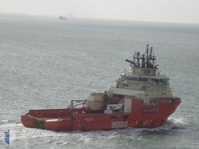
ATLANTIC KESTREL
Anchor Handling Vessel
Current Trip
FI RAU>CA SJF
| Time Travelled | 1 day |
|---|---|
| Remaining Time | --- |
| Distance Travelled | --- |
| Remaining Distance | --- |
| AVG Speed | --- |
| MAX Speed | --- |
| AVG Wind | --- |
| MAX Wind | --- |
| MIN Temp | --- |
| MAX Temp | --- |
| Draught | 6.9 m |
| Position Received | 8 d ago |
Current Position
| Longitude | -52.70400° |
|---|---|
| Latitude | 47.56517° |
| Status | Moored |
| Speed | |
| Course | 215° |
| Area | North Atlantic Ocean |
| Station | T-AIS |
| Position Received | 8 d ago |
Info
Information
The current position of ATLANTIC KESTREL is in North Atlantic Ocean with coordinates 47.56517° / -52.70400° as reported on 2024-05-30 00:09 by AIS to our vessel tracker app. The vessel's current speed is 0 Knots
The vessel ATLANTIC KESTREL (IMO: 9557446, MMSI: 316023651) is a Anchor Handling Vessel that was built in 2012 ( 12 years old ). It's sailing under the flag of [CA] Canada.
In this page you can find informations about the vessels current position, last detected port calls, and current voyage information. If the vessels is not in coverage by AIS you will find the latest position.
The current position of ATLANTIC KESTREL is detected by our AIS receivers and we are not responsible for the reliability of the data. The last position was recorded while the vessel was in Coverage by the Ais receivers of our vessel tracking app.
The current draught of ATLANTIC KESTREL as reported by AIS is 6.9 meters
Weather
| Temperature | 9.1°C / 48.38°F |
|---|---|
| Wind Speed | 10 knots |
| Direction | 137° SE |
| Pressure | 1010.2 hPa |
| Humidity | 95.7 % |
| Cloud Coverage | 100 % |
Featured Company
Last Port Calls
| Port | Arrival | Departure | Time In Port |
|---|---|---|---|
| 2024-05-28 15:08 | 2024-06-05 15:41 | 8 d | |
| 2024-05-27 10:12 | 2024-05-28 11:26 | 1 d | |
| 2024-05-15 03:47 | 2024-05-15 19:44 | 15 h | |
| 2024-05-10 02:51 | 2024-05-10 15:10 | 12 h | |
| 2024-04-16 08:57 | 2024-05-08 01:36 | 21 d | |
| 2024-04-03 08:50 | 2024-04-08 13:58 | 5 d | |
| 2024-04-03 05:12 |
Last Trips
| Origin | Departure | Destination | Arrival | Distance | |
|---|---|---|---|---|---|
| 2024-05-28 08:56 | 2024-05-28 12:38 | 5.88 nm | |||
| 2024-05-15 22:44 | 2024-05-27 07:42 | 3114.13 nm | |||
| 2024-05-10 16:10 | 2024-05-15 06:47 | 1127.83 nm | |||
| 2024-05-08 02:36 | 2024-05-10 03:51 | 11.68 nm | |||
| 2024-04-08 14:58 | 2024-04-16 09:57 | 480.74 nm | |||
| 2024-04-03 06:12 | 2024-04-03 09:50 | 29.40 nm |
Events
| Time | Event | Details | Position / Dest | Info |
|---|---|---|---|---|
| 2024-06-05 15:55 | START Moving | 2.25 nm, East of ST JOHNS |
47.56240 / -52.64225
FI RAU>CA SJF
|
Speed: 10.4 kn Course: 101° |
| 2024-06-05 15:41 | PORT DEPARTURE |
|
47.56240 / -52.64225
FI RAU>CA SJF
|
Speed: 0.3 kn Course: 221° |
| 2024-05-30 00:21 | Status Changed | Default Moored |
47.56517 / -52.70400
[CA] ST JOHNS
|
Speed: Course: 215° |
| 2024-05-30 00:09 | Status Changed | Moored Default |
47.56517 / -52.70400
[CA] ST JOHNS
|
Speed: 0.1 kn Course: 215° |
| 2024-05-30 00:09 | OUT of Coverage |
47.56517 / -52.70400
North Atlantic Ocean
[CA] ST JOHNS
|
Speed: Course: 117° |
|
| 2024-05-30 00:03 | Status Changed | Default Moored |
47.56517 / -52.70400
[CA] ST JOHNS
|
Speed: 0.1 kn Course: 215° |
| 2024-05-29 23:51 | Status Changed | Moored Default |
47.56514 / -52.70397
[CA] ST JOHNS
|
Speed: 0.1 kn Course: 215° |
| 2024-05-29 23:51 | IN Coverage |
47.56514 / -52.70397
North Atlantic Ocean
[CA] ST JOHNS
|
Speed: 0.1 kn Course: 48° |
|
| 2024-05-29 12:30 | Status Changed | Default Moored |
47.56517 / -52.70400
[CA] ST JOHNS
|
Speed: 0.1 kn Course: 215° |
| 2024-05-29 12:15 | OUT of Coverage |
47.56517 / -52.70400
North Atlantic Ocean
[CA] ST JOHNS
|
Speed: 0.1 kn Course: 353° |