
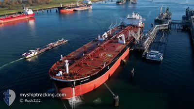
ATLANTIC M
Tanker
Current Trip
| Time Travelled | 20 days |
|---|---|
| Remaining Time | --- |
| Distance Travelled | 5660.63 nm |
| Remaining Distance | --- |
| AVG Speed | 11.7 Knots |
| MAX Speed | 15.3 Knots |
| AVG Wind | 11.2 knots |
| MAX Wind | 26.9 knots |
| MIN Temp | 7.6°C / 45.68°F |
| MAX Temp | 28.9°C / 84.02°F |
| Draught | 15.7 m |
| Position Received | 9 d ago |
Current Position
| Longitude | -16.12501° |
|---|---|
| Latitude | 25.31644° |
| Status | Under way using engine |
| Speed | 12 Knots |
| Course | 219.7° |
| Area | North Atlantic Ocean |
| Station | T-AIS |
| Position Received | 9 d ago |
Info
Information
The current position of ATLANTIC M is in North Atlantic Ocean with coordinates 25.31644° / -16.12501° as reported on 2024-05-08 12:38 by AIS to our vessel tracker app. The vessel's current speed is 12 Knots and is heading at the port of LOS ANGELES. The estimated time of arrival as calculated by vessel tracking app is 2024-06-16 00:01 LT
The vessel ATLANTIC M (IMO: 9907237, MMSI: 563172100) is a Tanker It's sailing under the flag of [SG] Singapore.
In this page you can find informations about the vessels current position, last detected port calls, and current voyage information. If the vessels is not in coverage by AIS you will find the latest position.
The current position of ATLANTIC M is detected by our AIS receivers and we are not responsible for the reliability of the data. The last position was recorded while the vessel was in Coverage by the Ais receivers of our vessel tracking app.
The current draught of ATLANTIC M as reported by AIS is 15.7 meters
Weather
| Temperature | 27.2°C / 80.96°F |
|---|---|
| Wind Speed | 10 knots |
| Direction | 77° ENE |
| Pressure | 1016.9 hPa |
| Humidity | 75.7 % |
| Cloud Coverage | 8 % |
Featured Company
Last Port Calls
| Port | Arrival | Departure | Time In Port |
|---|---|---|---|
| 2024-04-27 10:36 | 2024-04-27 11:50 | 1 h | |
| 2024-04-07 10:31 | 2024-04-08 11:47 | 1 d | |
| 2024-04-02 06:39 | 2024-04-03 02:49 | 20 h |
Most Visited Ports (Last year)
| Port | Arrivals | |
|---|---|---|
| 4 | ||
| 4 | ||
| 2 | ||
| 1 | ||
| 1 | ||
| 1 |
Last Trips
| Origin | Departure | Destination | Arrival | Distance | |
|---|---|---|---|---|---|
| 2024-04-08 13:47 | 2024-04-27 13:36 | 3812.56 nm | |||
| 2024-04-03 04:49 | 2024-04-07 12:31 | 1177.85 nm | |||
| 2024-02-25 08:08 | 2024-04-02 08:39 | 3139.06 nm |
Events
| Time | Event | Details | Position / Dest | Info |
|---|---|---|---|---|
| 2024-05-08 12:42 | Status Changed | Default Under way using engine |
25.30386 / -16.13623
USLGB
|
Speed: 12 kn Course: 219.7° |
| 2024-05-08 12:38 | OUT of Coverage |
25.31644 / -16.12501
North Atlantic Ocean
|
Speed: 12 kn Course: 219.7° |
|
| 2024-05-08 12:09 | Status Changed | Under way using engine Default |
25.39029 / -16.05792
USLGB
|
Speed: 12.5 kn Course: 219° |
| 2024-05-08 12:06 | IN Coverage |
25.38765 / -16.06040
North Atlantic Ocean
|
Speed: 12.4 kn Course: 220.6° |
|
| 2024-05-08 10:44 | Status Changed | Default Under way using engine |
25.61891 / -15.85711
USLGB
|
Speed: 12 kn Course: 220.6° |
| 2024-05-08 10:39 | Status Changed | Under way using engine Default |
25.62997 / -15.84703
USLGB
|
Speed: 12 kn Course: 221° |
| 2024-05-08 10:39 | OUT of Coverage |
25.62997 / -15.84703
North Atlantic Ocean
|
Speed: 12 kn Course: 220.6° |
|
| 2024-05-08 10:34 | Status Changed | Default Under way using engine |
25.64222 / -15.83542
USLGB
|
Speed: 11.9 kn Course: 220.5° |
| 2024-05-08 10:22 | Status Changed | Under way using engine Default |
25.67312 / -15.80670
USLGB
|
Speed: 11.9 kn Course: 218° |
| 2024-05-08 10:14 | Status Changed | Default Under way using engine |
25.69326 / -15.78848
USLGB
|
Speed: 12 kn Course: 220.4° |