
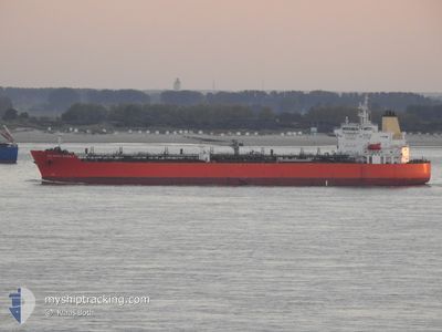
ATLANTIC MARBLE
Tanker
Current Trip
YINGKO CHINA
| Time Travelled | 42 days |
|---|---|
| Remaining Time | --- |
| Distance Travelled | 8505.62 nm |
| Remaining Distance | --- |
| AVG Speed | 10.8 Knots |
| MAX Speed | 15.3 Knots |
| AVG Wind | 13.2 knots |
| MAX Wind | 30.1 knots |
| MIN Temp | 15.3°C / 59.54°F |
| MAX Temp | 30.6°C / 87.08°F |
| Draught | 8.5 m |
| Position Received | 2 h, 53 m ago |
Current Position
| Longitude | 124.21858° |
|---|---|
| Latitude | 35.24361° |
| Status | Under way using engine |
| Speed | 11.6 Knots |
| Course | 350.7° |
| Area | Yellow Sea |
| Station | T-AIS |
| Position Received | 2 h, 53 m ago |
Info
Information
The current position of ATLANTIC MARBLE is in Yellow Sea with coordinates 35.24361° / 124.21858° as reported on 2024-06-03 14:19 by AIS to our vessel tracker app. The vessel's current speed is 11.6 Knots
The vessel ATLANTIC MARBLE (IMO: 9798959, MMSI: 538007896) is a Tanker It's sailing under the flag of [MH] Marshall Is.
In this page you can find informations about the vessels current position, last detected port calls, and current voyage information. If the vessels is not in coverage by AIS you will find the latest position.
The current position of ATLANTIC MARBLE is detected by our AIS receivers and we are not responsible for the reliability of the data. The last position was recorded while the vessel was in Coverage by the Ais receivers of our vessel tracking app.
The current draught of ATLANTIC MARBLE as reported by AIS is 8.5 meters
Weather
| Temperature | 19°C / 66.2°F |
|---|---|
| Wind Speed | 7 knots |
| Direction | 35° NE |
| Pressure | 1013.8 hPa |
| Humidity | 74 % |
| Cloud Coverage | --- |
Featured Company
Events
| Time | Event | Details | Position / Dest | Info |
|---|---|---|---|---|
| 2024-06-03 14:20 | Status Changed | Default Under way using engine |
35.24569 / 124.21819
YINGKO CHINA
|
Speed: 11.6 kn Course: 350.7° |
| 2024-06-03 14:19 | OUT of Coverage |
35.24361 / 124.21858
Yellow Sea
YINGKO CHINA
|
Speed: 11.6 kn Course: 350.7° |
|
| 2024-06-03 13:42 | Draught Changed | 8.5 10.1 |
35.12194 / 124.24375
YINGKO CHINA
|
Speed: 11.7 kn Course: 350.2° |
| 2024-06-03 13:42 | Destination Changed | YINGKO CHINA CNZOS |
35.12194 / 124.24375
YINGKO CHINA
|
Speed: 11.7 kn Course: 350.2° |
| 2024-06-03 13:42 | ETA Changed | 2024/06/05 04:00 2024/05/29 05:00 |
35.12194 / 124.24375
YINGKO CHINA
|
Speed: 11.7 kn Course: 350.2° |
| 2024-06-03 13:25 | Status Changed | Under way using engine Default |
35.06853 / 124.25436
CNZOS
|
Speed: 11.7 kn Course: 351° |
| 2024-06-03 13:11 | IN Coverage |
35.06853 / 124.25436
Yellow Sea
|
Speed: 11.7 kn Course: 350.9° |
|
| 2024-06-03 11:12 | Status Changed | Default Under way using engine |
34.64307 / 124.33613
CNZOS
|
Speed: 11.4 kn Course: 352.4° |
| 2024-06-03 11:11 | OUT of Coverage |
34.64095 / 124.33641
Yellow Sea
|
Speed: 11.4 kn Course: 352.4° |
|
| 2024-06-03 11:11 | Detected in Sea | South Korean part of the Yellow Sea |
34.64095 / 124.33641
Yellow Sea
|
Speed: 11.4 kn Course: 352.4° |