
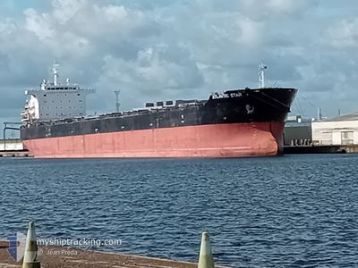
ATLANTIC STAR
Bulk Carrier
Current Trip
| Time Travelled | 7 days |
|---|---|
| Remaining Time | --- |
| Distance Travelled | 95.91 nm |
| Remaining Distance | --- |
| AVG Speed | 8.3 Knots |
| MAX Speed | 10.7 Knots |
| AVG Wind | 9.8 knots |
| MAX Wind | 11.8 knots |
| MIN Temp | 23.7°C / 74.66°F |
| MAX Temp | 24.5°C / 76.1°F |
| Draught | 14.4 m |
| Position Received | 6 d ago |
Current Position
| Longitude | -74.45620° |
|---|---|
| Latitude | 36.30765° |
| Status | Under way using engine |
| Speed | 10.7 Knots |
| Course | 118.2° |
| Area | North Atlantic Ocean |
| Station | T-AIS |
| Position Received | 6 d ago |
Info
Information
The current position of ATLANTIC STAR is in North Atlantic Ocean with coordinates 36.30765° / -74.45620° as reported on 2024-06-20 11:58 by AIS to our vessel tracker app. The vessel's current speed is 10.7 Knots and is heading at the port of KANDLA. The estimated time of arrival as calculated by vessel tracking app is 2024-08-02 12:00 LT
The vessel ATLANTIC STAR (IMO: 9473327, MMSI: 636024099) is a Bulk Carrier that was built in 2011 ( 13 years old ). It's sailing under the flag of [LR] Liberia.
In this page you can find informations about the vessels current position, last detected port calls, and current voyage information. If the vessels is not in coverage by AIS you will find the latest position.
The current position of ATLANTIC STAR is detected by our AIS receivers and we are not responsible for the reliability of the data. The last position was recorded while the vessel was in Coverage by the Ais receivers of our vessel tracking app.
The current draught of ATLANTIC STAR as reported by AIS is 14.4 meters
Weather
| Temperature | 24.1°C / 75.38°F |
|---|---|
| Wind Speed | 8 knots |
| Direction | 109° ESE |
| Pressure | 1027.3 hPa |
| Humidity | 64.8 % |
| Cloud Coverage | 71 % |
Featured Company
Most Visited Ports (Last year)
| Port | Arrivals | |
|---|---|---|
| 1 |
Events
| Time | Event | Details | Position / Dest | Info |
|---|---|---|---|---|
| 2024-06-20 11:58 | OUT of Coverage |
36.30765 / -74.45620
North Atlantic Ocean
|
Speed: 10.7 kn Course: 118.2° |
|
| 2024-06-20 09:44 | IN Coverage |
36.54035 / -74.84279
North Atlantic Ocean
|
Speed: 10.3 kn Course: 140° |
|
| 2024-06-20 02:06 | OUT of Coverage |
36.96462 / -76.07543
North Atlantic Ocean
|
Speed: 7.1 kn Course: 109.7° |
|
| 2024-06-20 00:41 | PORT DEPARTURE |
|
37.00609 / -76.26804
IN IXY
|
Speed: 7 kn Course: 78° |
| 2024-06-19 23:08 | START Moving |
36.96014 / -76.42554
[US] NORFOLK
|
Speed: 3.2 kn Course: 130° |
|
| 2024-06-19 22:59 | Status Changed | Under way using engine Moored |
36.96109 / -76.42577
[US] NORFOLK
|
Speed: 0.9 kn Course: 60° |
| 2024-06-19 22:39 | Destination Changed | IN IXY IN KDA |
36.96256 / -76.42367
[US] NORFOLK
|
Speed: Course: 38° |
| 2024-06-19 22:31 | ETA Changed | 2024/08/02 12:00 2024/07/30 20:00 |
36.96256 / -76.42367
[US] NORFOLK
|
Speed: Course: 38° |
| 2024-06-19 21:43 | Destination Changed | IN KDA RES RASADES |
36.96257 / -76.42367
[US] NORFOLK
|
Speed: Course: 38° |
| 2024-06-19 21:19 | Destination Changed | RES RASADES USNNS |
36.96257 / -76.42367
[US] NORFOLK
|
Speed: Course: 38° |