
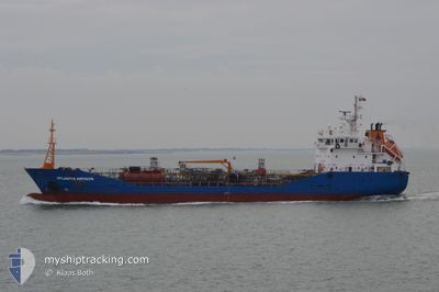
ATLANTIS ANTALYA
Oil/Chemical Tanker
Current Trip
| Time Travelled | 1 day |
|---|---|
| Remaining Time | --- |
| Distance Travelled | 217.93 nm |
| Remaining Distance | --- |
| AVG Speed | 10 Knots |
| MAX Speed | 12.8 Knots |
| AVG Wind | 8 knots |
| MAX Wind | 17 knots |
| MIN Temp | 22.8°C / 73.04°F |
| MAX Temp | 28.4°C / 83.12°F |
| Draught | 4.7 m |
| Position Received | 4 m ago |
Current Position
| Longitude | 28.23183° |
|---|---|
| Latitude | 36.41123° |
| Status | Moored |
| Speed | |
| Course | 94° |
| Area | Mediterranean Sea - Eastern Basin |
| Station | T-AIS |
| Position Received | 4 m ago |
Info
Information
The current position of ATLANTIS ANTALYA is in Mediterranean Sea - Eastern Basin with coordinates 36.41123° / 28.23183° as reported on 2024-06-10 12:18 by AIS to our vessel tracker app. The vessel's current speed is 0 Knots and is heading at the port of RHODES. The estimated time of arrival as calculated by vessel tracking app is 2024-06-10 08:00 LT
The vessel ATLANTIS ANTALYA (IMO: 9305350, MMSI: 248252000) is a Oil/Chemical Tanker that was built in 2004 ( 20 years old ). It's sailing under the flag of [MT] Malta.
In this page you can find informations about the vessels current position, last detected port calls, and current voyage information. If the vessels is not in coverage by AIS you will find the latest position.
The current position of ATLANTIS ANTALYA is detected by our AIS receivers and we are not responsible for the reliability of the data. The last position was recorded while the vessel was in Coverage by the Ais receivers of our vessel tracking app.
The current draught of ATLANTIS ANTALYA as reported by AIS is 4.7 meters
Weather
| Temperature | 26.7°C / 80.06°F |
|---|---|
| Wind Speed | 5 knots |
| Direction | 227° SW |
| Pressure | 1009.6 hPa |
| Humidity | 66 % |
| Cloud Coverage | --- |
Featured Company
Last Port Calls
| Port | Arrival | Departure | Time In Port |
|---|---|---|---|
| 2024-06-09 05:40 | 2024-06-09 11:25 | 5 h | |
| 2024-06-07 18:48 | 2024-06-08 15:43 | 20 h | |
| 2024-06-04 07:48 | 2024-06-04 18:15 | 10 h | |
| 2024-06-02 21:35 | 2024-06-03 17:46 | 20 h | |
| 2024-05-30 04:39 | 2024-05-30 16:55 | 12 h | |
| 2024-05-26 04:06 | 2024-05-27 01:20 | 21 h | |
| 2024-05-21 14:18 | 2024-05-22 05:45 | 15 h | |
| 2024-05-17 03:43 | 2024-05-17 12:47 | 9 h | |
| 2024-05-15 12:35 | 2024-05-16 10:06 | 21 h | |
| 2024-05-13 16:51 | 2024-05-14 09:59 | 17 h |
Most Visited Ports (Last year)
| Port | Arrivals | |
|---|---|---|
| 27 | ||
| 26 | ||
| 4 | ||
| 2 | ||
| 2 | ||
| 1 |
Last Trips
| Origin | Departure | Destination | Arrival | Distance | |
|---|---|---|---|---|---|
| 2024-06-08 18:43 | 2024-06-09 08:40 | 160.40 nm | |||
| 2024-06-04 21:15 | 2024-06-07 21:48 | 508.73 nm | |||
| 2024-06-03 20:46 | 2024-06-04 10:48 | 160.11 nm | |||
| 2024-05-30 19:55 | 2024-06-03 00:35 | 507.81 nm | |||
| 2024-05-27 04:20 | 2024-05-30 07:39 | 165.46 nm | |||
| 2024-05-22 08:45 | 2024-05-26 07:06 | 559.40 nm | |||
| 2024-05-17 15:47 | 2024-05-21 17:18 | 497.59 nm | |||
| 2024-05-16 13:06 | 2024-05-17 06:43 | 159.32 nm | |||
| 2024-05-14 12:59 | 2024-05-15 15:35 | 254.27 nm | |||
| 2024-05-12 21:46 | 2024-05-13 19:51 | 253.24 nm |
Events
| Time | Event | Details | Position / Dest | Info |
|---|---|---|---|---|
| 2024-06-10 10:51 | Status Changed | Moored Default |
36.41123 / 28.23184
GRCHQ>GRRHO
|
Speed: Course: 92° |
| 2024-06-10 10:47 | Status Changed | Default Moored |
36.41122 / 28.23185
GRCHQ>GRRHO
|
Speed: Course: 94° |
| 2024-06-10 10:30 | Status Changed | Moored Default |
36.41121 / 28.23183
GRCHQ>GRRHO
|
Speed: Course: 92° |
| 2024-06-10 10:26 | IN Coverage |
36.41121 / 28.23183
Mediterranean Sea - Eastern Basin
GRCHQ>GRRHO
|
Speed: Course: 205° |
|
| 2024-06-10 08:39 | Status Changed | Default Under way using engine |
36.41123 / 28.23184
GRCHQ>GRRHO
|
Speed: 0.2 kn Course: 99° |
| 2024-06-10 08:19 | OUT of Coverage |
36.41119 / 28.23209
Mediterranean Sea - Eastern Basin
GRCHQ>GRRHO
|
Speed: 0.2 kn Course: 296.9° |
|
| 2024-06-10 08:14 | STOP Moving | 2.34 nm, South of RHODES |
36.41111 / 28.23231
GRCHQ>GRRHO
|
Speed: 0.3 kn Course: 89° |
| 2024-06-10 07:22 | Change Sea Area | Greek part of the Mediterranean Sea - Eastern Basin Greek part of the Aegean Sea |
36.47897 / 28.22327
Mediterranean Sea - Eastern Basin
GRCHQ>GRRHO
|
Speed: 10.2 kn Course: 111.9° |
| 2024-06-10 07:12 | Status Changed | Under way using engine Default |
36.48011 / 28.18779
GRCHQ>GRRHO
|
Speed: 11.1 kn Course: 79° |
| 2024-06-10 07:07 | Status Changed | Default Under way using engine |
36.47626 / 28.16365
GRCHQ>GRRHO
|
Speed: 11.1 kn Course: 79.2° |