
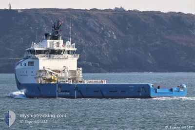
AURORA HORIZON
Cargo
Current Trip
| Trip Time | 5 days |
|---|---|
| Trip Distance | 174.41 nm |
| AVG Speed | 8.3 Knots |
| MAX Speed | 8.3 Knots |
| Draught | 5.7 m |
| AVG Wind | 8.9 knots |
| MAX Wind | 17 knots |
| MIN Temp | 21.2°C / 70.16°F |
| MAX Temp | 29.1°C / 84.38°F |
| Position Received | 2 h, 50 m ago |
Current Position
| Longitude | 30.07410° |
|---|---|
| Latitude | 31.32080° |
| Status | Under way using engine |
| Speed | 0.9 Knots |
| Course | 228° |
| Area | Mediterranean Sea - Eastern Basin |
| Station | T-AIS |
| Position Received | 2 h, 50 m ago |
Info
Information
The current position of AURORA HORIZON is in Mediterranean Sea - Eastern Basin with coordinates 31.32080° / 30.07410° as reported on 2024-06-01 14:00 by AIS to our vessel tracker app. The vessel's current speed is 0.9 Knots and is currently inside the port of ABU QIR.
The vessel AURORA HORIZON (IMO: 9747493, MMSI: 258039000) is a Cargo It's sailing under the flag of [NO] Norway.
In this page you can find informations about the vessels current position, last detected port calls, and current voyage information. If the vessels is not in coverage by AIS you will find the latest position.
The current position of AURORA HORIZON is detected by our AIS receivers and we are not responsible for the reliability of the data. The last position was recorded while the vessel was in Coverage by the Ais receivers of our vessel tracking app.
The current draught of AURORA HORIZON as reported by AIS is 5.7 meters
Weather
| Temperature | 29°C / 84.2°F |
|---|---|
| Wind Speed | 10 knots |
| Direction | 48° NE |
| Pressure | 1015.6 hPa |
| Humidity | 41.9 % |
| Cloud Coverage | --- |
Featured Company
Last Port Calls
| Port | Arrival | Departure | Time In Port |
|---|---|---|---|
| 2024-06-01 13:52 | |||
| 2024-05-23 09:23 | 2024-05-26 18:43 | 3 d | |
| 2024-05-23 08:13 | 2024-05-23 08:49 | 35 m | |
| 2024-05-07 21:58 | 2024-05-08 12:06 | 14 h | |
| 2024-05-07 19:53 | |||
| 2024-04-16 21:32 | |||
| 2024-04-03 00:02 | 2024-04-03 19:41 | 19 h |
Most Visited Ports (Last year)
| Port | Arrivals | |
|---|---|---|
| 26 | ||
| 11 | ||
| 10 | ||
| 8 | ||
| 1 | ||
| 1 |
Last Trips
| Origin | Departure | Destination | Arrival | Distance | |
|---|---|---|---|---|---|
| 2024-05-26 20:43 | 2024-06-01 15:52 | 174.41 nm | |||
| 2024-05-23 10:49 | 2024-05-23 11:23 | 5.16 nm | |||
| 2024-05-08 14:06 | 2024-05-23 10:13 | 212.94 nm | |||
| 2024-05-07 21:53 | 2024-05-07 23:58 | 10.79 nm | |||
| 2024-03-01 18:08 | 2024-04-03 02:02 | 125.17 nm |
Events
| Time | Event | Details | Position / Dest | Info |
|---|---|---|---|---|
| 2024-06-01 14:00 | OUT of Coverage |
31.32080 / 30.07410
Mediterranean Sea - Eastern Basin
[EG] ABU QIR
|
Speed: 0.9 kn Course: 235.8° |
|
| 2024-06-01 13:52 | PORT ARRIVAL |
|
31.32615 / 30.08462
[EG] ABU QIR
|
Speed: 2.8 kn Course: 323° |
| 2024-06-01 13:12 | IN Coverage |
31.33226 / 30.08808
Mediterranean Sea - Eastern Basin
|
Speed: 6.3 kn Course: 24° |
|
| 2024-06-01 01:47 | OUT of Coverage |
31.39303 / 30.11163
Mediterranean Sea - Eastern Basin
|
Speed: Course: 204.1° |
|
| 2024-06-01 01:47 | STOP Moving | 4.93 nm, North of ABU QIR |
31.39303 / 30.11163
ABU QIR
|
Speed: Course: 203° |
| 2024-06-01 01:41 | IN Coverage |
31.39777 / 30.11493
Mediterranean Sea - Eastern Basin
|
Speed: 6.5 kn Course: 204.4° |
|
| 2024-05-31 23:09 | OUT of Coverage |
31.66048 / 30.28370
Mediterranean Sea - Eastern Basin
|
Speed: 7.6 kn Course: 218.2° |
|
| 2024-05-31 23:09 | IN Coverage |
31.66048 / 30.28370
Mediterranean Sea - Eastern Basin
|
Speed: 7.6 kn Course: 218.2° |
|
| 2024-05-31 20:32 | OUT of Coverage |
31.91691 / 30.53213
Mediterranean Sea - Eastern Basin
|
Speed: 7.5 kn Course: 221.3° |
|
| 2024-05-31 20:16 | IN Coverage |
31.94250 / 30.55867
Mediterranean Sea - Eastern Basin
|
Speed: 7.4 kn Course: 222° |