
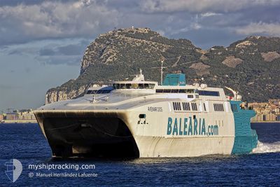
AVEMAR DOS
High speed craft
Current Trip
| Trip Time | 45 mins |
|---|---|
| Trip Distance | 15.91 nm |
| AVG Speed | 19.4 Knots |
| MAX Speed | 19.4 Knots |
| Draught | 2.5 m |
| AVG Wind | 11.9 knots |
| MAX Wind | 14.9 knots |
| MIN Temp | 17.5°C / 63.5°F |
| MAX Temp | 19.3°C / 66.74°F |
| Position Received | Now |
Current Position
| Longitude | -5.43908° |
|---|---|
| Latitude | 36.12928° |
| Status | Under way using engine |
| Speed | |
| Course | 55° |
| Area | Strait of Gibraltar |
| Station | T-AIS |
| Position Received | Now |
Info
Information
The current position of AVEMAR DOS is in Strait of Gibraltar with coordinates 36.12928° / -5.43908° as reported on 2024-06-01 03:39 by AIS to our vessel tracker app. The vessel's current speed is 0 Knots and is currently inside the port of ALGECIRAS.
The vessel AVEMAR DOS (IMO: 9170183, MMSI: 224704000) is a High speed craft that was built in 1997 ( 27 years old ). It's sailing under the flag of [ES] Spain.
In this page you can find informations about the vessels current position, last detected port calls, and current voyage information. If the vessels is not in coverage by AIS you will find the latest position.
The current position of AVEMAR DOS is detected by our AIS receivers and we are not responsible for the reliability of the data. The last position was recorded while the vessel was in Coverage by the Ais receivers of our vessel tracking app.
The current draught of AVEMAR DOS as reported by AIS is 2.5 meters
Weather
| Temperature | 17.8°C / 64.04°F |
|---|---|
| Wind Speed | 13 knots |
| Direction | 93° E |
| Pressure | 1011.9 hPa |
| Humidity | 89.5 % |
| Cloud Coverage | 100 % |
Featured Company
Last Port Calls
| Port | Arrival | Departure | Time In Port |
|---|---|---|---|
| 2024-05-31 21:12 | |||
| 2024-05-31 19:24 | 2024-05-31 20:27 | 1 h | |
| 2024-05-31 16:45 | 2024-05-31 18:45 | 2 h | |
| 2024-05-31 15:04 | 2024-05-31 15:55 | 51 m | |
| 2024-05-31 13:31 | 2024-05-31 14:25 | 53 m | |
| 2024-05-31 11:57 | 2024-05-31 12:45 | 47 m | |
| 2024-05-31 10:21 | 2024-05-31 11:17 | 55 m | |
| 2024-05-31 08:47 | 2024-05-31 09:41 | 53 m | |
| 2024-05-31 07:21 | 2024-05-31 08:09 | 47 m | |
| 2024-05-31 05:48 | 2024-05-31 06:44 | 56 m |
Last Trips
| Origin | Departure | Destination | Arrival | Distance | |
|---|---|---|---|---|---|
| 2024-05-31 22:27 | 2024-05-31 23:12 | 15.91 nm | |||
| 2024-05-31 20:45 | 2024-05-31 21:24 | 17.25 nm | |||
| 2024-05-31 17:55 | 2024-05-31 18:45 | 16.58 nm | |||
| 2024-05-31 16:25 | 2024-05-31 17:04 | 16.66 nm | |||
| 2024-05-31 14:45 | 2024-05-31 15:31 | 16.50 nm | |||
| 2024-05-31 13:17 | 2024-05-31 13:57 | 16.59 nm | |||
| 2024-05-31 11:41 | 2024-05-31 12:21 | 16.44 nm | |||
| 2024-05-31 10:09 | 2024-05-31 10:47 | 16.73 nm | |||
| 2024-05-31 08:44 | 2024-05-31 09:21 | 15.15 nm | |||
| 2024-05-31 07:09 | 2024-05-31 07:48 | 16.48 nm |
Events
| Time | Event | Details | Position / Dest | Info |
|---|---|---|---|---|
| 2024-06-01 00:00 | ETA Changed | 2025/05/31 23:15 2024/05/31 23:15 |
36.12928 / -5.43910
[ES] ALGECIRAS
|
Speed: Course: 55° |
| 2024-05-31 21:24 | STOP Moving |
36.12934 / -5.43891
[ES] ALGECIRAS
|
Speed: 0.3 kn Course: 59° |
|
| 2024-05-31 21:12 | PORT ARRIVAL |
|
36.14866 / -5.43189
[ES] ALGECIRAS
|
Speed: 8.7 kn Course: 217.3° |
| 2024-05-31 21:07 | Change Sea Area | Spanish part of the Strait of Gibraltar Gibraltarian part of the Strait of Gibraltar |
36.14606 / -5.41153
Strait of Gibraltar
ALG-CEU-ALG
|
Speed: 14.9 kn Course: 298.2° |
| 2024-05-31 20:46 | Change Sea Area | Gibraltarian part of the Strait of Gibraltar Spanish part of the Strait of Gibraltar |
36.02508 / -5.33573
Strait of Gibraltar
ALG-CEU-ALG
|
Speed: 19.5 kn Course: 346.8° |
| 2024-05-31 20:42 | Status Changed | Under way using engine Default |
36.00417 / -5.32902
ALG-CEU-ALG
|
Speed: 19.5 kn Course: 351° |
| 2024-05-31 20:42 | ETA Changed | 2024/05/31 23:15 2024/05/31 21:30 |
35.99111 / -5.32545
ALG-CEU-ALG
|
Speed: 19.5 kn Course: 351° |
| 2024-05-31 20:32 | IN Coverage |
36.00882 / -5.33058
Strait of Gibraltar
ALG-CEU-ALG
|
Speed: 19.2 kn Course: 344.5° |
|
| 2024-05-31 20:27 | PORT DEPARTURE |
|
35.92169 / -5.31600
ALG-CEU-ALG
|
Speed: 6.7 kn Course: 71° |
| 2024-05-31 19:29 | OUT of Coverage |
35.89528 / -5.32193
Strait of Gibraltar
[ES] CEUTA
|
Speed: 1.1 kn Course: 270.7° |