
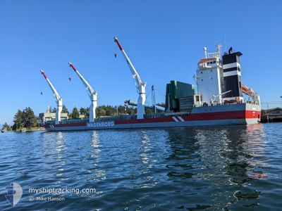
AVONBORG
General Cargo
Current Trip
NOARD
| Time Travelled | 8 days |
|---|---|
| Remaining Time | --- |
| Distance Travelled | 2614.06 nm |
| Remaining Distance | --- |
| AVG Speed | 12.6 Knots |
| MAX Speed | 17.3 Knots |
| AVG Wind | 13.8 knots |
| MAX Wind | 26.8 knots |
| MIN Temp | 12°C / 53.6°F |
| MAX Temp | 31.2°C / 88.16°F |
| Draught | 8.8 m |
| Position Received | 5 d ago |
Current Position
| Longitude | -79.38880° |
|---|---|
| Latitude | 26.32074° |
| Status | Under way using engine |
| Speed | 14.7 Knots |
| Course | 4.5° |
| Area | North Atlantic Ocean |
| Station | T-AIS |
| Position Received | 5 d ago |
Info
Information
The current position of AVONBORG is in North Atlantic Ocean with coordinates 26.32074° / -79.38880° as reported on 2024-05-26 15:50 by AIS to our vessel tracker app. The vessel's current speed is 14.7 Knots
The vessel AVONBORG (IMO: 9466362, MMSI: 246865000) is a General Cargo that was built in 2012 ( 12 years old ). It's sailing under the flag of [NL] Netherlands.
In this page you can find informations about the vessels current position, last detected port calls, and current voyage information. If the vessels is not in coverage by AIS you will find the latest position.
The current position of AVONBORG is detected by our AIS receivers and we are not responsible for the reliability of the data. The last position was recorded while the vessel was in Coverage by the Ais receivers of our vessel tracking app.
The current draught of AVONBORG as reported by AIS is 8.8 meters
Weather
| Temperature | 11.7°C / 53.06°F |
|---|---|
| Wind Speed | 16 knots |
| Direction | 162° SSE |
| Pressure | 1013.5 hPa |
| Humidity | 94.2 % |
| Cloud Coverage | 100 % |
Featured Company
Last Port Calls
| Port | Arrival | Departure | Time In Port |
|---|---|---|---|
| 2024-05-16 21:13 | 2024-05-23 19:54 | 6 d | |
| 2024-05-13 01:53 | 2024-05-15 01:58 | 2 d | |
| 2024-04-09 09:05 | 2024-04-12 06:14 | 2 d | |
| 2024-04-07 13:54 | 2024-04-08 20:26 | 1 d | |
| 2024-04-01 14:37 |
Most Visited Ports (Last year)
| Port | Arrivals | |
|---|---|---|
| 2 | ||
| 2 | ||
| 2 | ||
| 2 | ||
| 2 | ||
| 1 |
Last Trips
| Origin | Departure | Destination | Arrival | Distance | |
|---|---|---|---|---|---|
| 2024-05-14 20:58 | 2024-05-16 16:13 | 426.25 nm | |||
| 2024-04-12 08:14 | 2024-05-12 20:53 | 6766.61 nm | |||
| 2024-04-08 22:26 | 2024-04-09 11:05 | 132.26 nm | |||
| 2024-04-01 16:37 | 2024-04-07 15:54 | 1714.50 nm |
Events
| Time | Event | Details | Position / Dest | Info |
|---|---|---|---|---|
| 2024-05-26 15:52 | Status Changed | Default Under way using engine |
26.33000 / -79.38834
NOARD
|
Speed: 14.7 kn Course: 4.5° |
| 2024-05-26 15:50 | OUT of Coverage |
26.32074 / -79.38880
North Atlantic Ocean
|
Speed: 14.7 kn Course: 4.5° |
|
| 2024-05-26 14:52 | Status Changed | Under way using engine Default |
26.08393 / -79.43108
NOARD
|
Speed: 15 kn Course: 11° |
| 2024-05-26 14:10 | Status Changed | Default Under way using engine |
25.91833 / -79.46500
NOARD
|
Speed: 14.6 kn Course: 21° |
| 2024-05-26 12:18 | Destination Changed | NOARD ARDALSTANGENLL |
25.47157 / -79.56111
NOARD
|
Speed: 14.6 kn Course: 10.1° |
| 2024-05-26 12:18 | ETA Changed | 2024/05/10 18:00 2024/05/09 18:00 |
25.47157 / -79.56111
NOARD
|
Speed: 14.6 kn Course: 10.1° |
| 2024-05-26 11:43 | Status Changed | Under way using engine Default |
25.33249 / -79.58782
ARDALSTANGENLL
|
Speed: 15 kn Course: 10° |
| 2024-05-26 11:37 | Status Changed | Default Under way using engine |
25.30667 / -79.59333
ARDALSTANGENLL
|
Speed: 14.6 kn Course: 9.5° |
| 2024-05-26 11:30 | Status Changed | Under way using engine Default |
25.28039 / -79.59770
ARDALSTANGENLL
|
Speed: 15 kn Course: 10° |
| 2024-05-26 11:25 | Status Changed | Default Under way using engine |
25.25833 / -79.60167
ARDALSTANGENLL
|
Speed: 14.6 kn Course: 10.1° |