
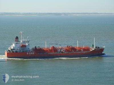
B GAS MAUD
Lpg Tanker
Current Trip
| Time Travelled | 2 days |
|---|---|
| Remaining Time | 4 h, 49 mins |
| Distance Travelled | 745.12 nm |
| Remaining Distance | 73.88 nm |
| AVG Speed | 12.9 Knots |
| MAX Speed | 15.9 Knots |
| AVG Wind | 13 knots |
| MAX Wind | 18.1 knots |
| MIN Temp | 10.4°C / 50.72°F |
| MAX Temp | 14.8°C / 58.64°F |
| Draught | 5.8 m |
| Position Received | 58 m ago |
Current Position
| Longitude | -3.65328° |
|---|---|
| Latitude | 47.19642° |
| Status | Under way using engine |
| Speed | 12.1 Knots |
| Course | 125° |
| Area | Bay of Biscay |
| Station | T-AIS |
| Position Received | 58 m ago |
Info
Information
The current position of B GAS MAUD is in Bay of Biscay with coordinates 47.19642° / -3.65328° as reported on 2024-06-01 03:03 by AIS to our vessel tracker app. The vessel's current speed is 12.1 Knots and is heading at the port of DONGES. The estimated time of arrival as calculated by vessel tracking app is 2024-06-01 08:51 LT
The vessel B GAS MAUD (IMO: 9363522, MMSI: 248102000) is a Lpg Tanker that was built in 2006 ( 18 years old ). It's sailing under the flag of [MT] Malta.
In this page you can find informations about the vessels current position, last detected port calls, and current voyage information. If the vessels is not in coverage by AIS you will find the latest position.
The current position of B GAS MAUD is detected by our AIS receivers and we are not responsible for the reliability of the data. The last position was recorded while the vessel was in Coverage by the Ais receivers of our vessel tracking app.
The current draught of B GAS MAUD as reported by AIS is 5.8 meters
Weather
| Temperature | 14.7°C / 58.46°F |
|---|---|
| Wind Speed | 15 knots |
| Direction | 27° NNE |
| Pressure | 1022.1 hPa |
| Humidity | 79.9 % |
| Cloud Coverage | 6 % |
Featured Company
Last Port Calls
| Port | Arrival | Departure | Time In Port |
|---|---|---|---|
| 2024-05-28 18:17 | 2024-05-29 16:53 | 22 h | |
| 2024-05-23 10:09 | 2024-05-24 18:15 | 1 d | |
| 2024-05-16 21:56 | 2024-05-19 08:32 | 2 d | |
| 2024-05-12 16:48 | 2024-05-14 04:06 | 1 d | |
| 2024-05-08 14:26 | 2024-05-10 21:23 | 2 d | |
| 2024-05-02 20:48 | 2024-05-04 07:43 | 1 d | |
| 2024-04-27 09:49 | 2024-05-01 01:31 | 3 d | |
| 2024-04-23 20:21 | 2024-04-24 19:50 | 23 h | |
| 2024-04-21 19:59 | 2024-04-23 08:32 | 1 d | |
| 2024-04-16 14:59 | 2024-04-18 10:54 | 1 d |
Most Visited Ports (Last year)
| Port | Arrivals | |
|---|---|---|
| 14 | ||
| 7 | ||
| 7 | ||
| 5 | ||
| 4 | ||
| 3 |
Last Trips
| Origin | Departure | Destination | Arrival | Distance | |
|---|---|---|---|---|---|
| 2024-05-24 20:15 | 2024-05-28 19:17 | 303.21 nm | |||
| 2024-05-19 09:32 | 2024-05-23 12:09 | 539.50 nm | |||
| 2024-05-14 06:06 | 2024-05-16 22:56 | 539.00 nm | |||
| 2024-05-10 22:23 | 2024-05-12 18:48 | 523.78 nm | |||
| 2024-05-04 09:43 | 2024-05-08 15:26 | 540.74 nm | |||
| 2024-05-01 02:31 | 2024-05-02 22:48 | 522.90 nm | |||
| 2024-04-24 21:50 | 2024-04-27 10:49 | 579.29 nm | |||
| 2024-04-23 10:32 | 2024-04-23 22:21 | 102.07 nm | |||
| 2024-04-18 11:54 | 2024-04-21 21:59 | 561.10 nm | |||
| 2024-04-07 04:25 | 2024-04-16 15:59 | 485.67 nm |
Events
| Time | Event | Details | Position / Dest | Info |
|---|---|---|---|---|
| 2024-06-01 03:45 | Status Changed | Default Under way using engine |
47.12102 / -3.48147
FR DONGES
|
Speed: 12.1 kn Course: 125° |
| 2024-06-01 01:27 | Change Sea Area | French part of the Bay of Biscay French part of the Celtic Sea |
47.35497 / -4.07707
Bay of Biscay
FR DONGES
|
Speed: 12.4 kn Course: 119° |
| 2024-06-01 01:27 | IN Coverage |
47.35497 / -4.07707
Bay of Biscay
FR DONGES
|
Speed: 12.4 kn Course: 119° |
|
| 2024-05-31 18:00 | Status Changed | Default Under way using engine |
48.36630 / -5.70337
FR DONGES
|
Speed: 12.3 kn Course: 147° |
| 2024-05-31 17:45 | Change Sea Area | French part of the Celtic Sea French part of the English Channel |
48.40933 / -5.74587
Celtic Sea
FR DONGES
|
Speed: 12.3 kn Course: 147° |
| 2024-05-31 17:45 | OUT of Coverage |
48.40933 / -5.74587
Celtic Sea
FR DONGES
|
Speed: 12.3 kn Course: 147° |
|
| 2024-05-31 17:45 | IN Coverage |
48.40933 / -5.74587
Celtic Sea
FR DONGES
|
Speed: 12.3 kn Course: 147° |
|
| 2024-05-31 09:51 | Status Changed | Default Under way using engine |
49.43657 / -4.37323
FR DONGES
|
Speed: 11.7 kn Course: 239° |
| 2024-05-31 09:47 | OUT of Coverage |
49.44268 / -4.35667
English Channel
FR DONGES
|
Speed: 11.7 kn Course: 239° |
|
| 2024-05-31 09:46 | Status Changed | Under way using engine Default |
49.44552 / -4.34965
FR DONGES
|
Speed: 11.7 kn Course: 237° |