
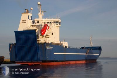
BALTIC BRIGHT
Vehicles Carrier
Current Trip
SEBVK
| Time Travelled | 2 days |
|---|---|
| Remaining Time | --- |
| Distance Travelled | 572.62 nm |
| Remaining Distance | --- |
| AVG Speed | 11.5 Knots |
| MAX Speed | 14 Knots |
| AVG Wind | 9.1 knots |
| MAX Wind | 12 knots |
| MIN Temp | 15.4°C / 59.72°F |
| MAX Temp | 20.6°C / 69.08°F |
| Draught | 5 m |
| Position Received | 1 m ago |
Current Position
| Longitude | 11.65676° |
|---|---|
| Latitude | 57.59551° |
| Status | Under way using engine |
| Speed | 4.9 Knots |
| Course | 85° |
| Area | Kattegat |
| Station | T-AIS |
| Position Received | 1 m ago |
Info
Information
The current position of BALTIC BRIGHT is in Kattegat with coordinates 57.59551° / 11.65676° as reported on 2024-06-27 12:29 by AIS to our vessel tracker app. The vessel's current speed is 4.9 Knots
The vessel BALTIC BRIGHT (IMO: 9129263, MMSI: 230042000) is a Vehicles Carrier that was built in 1996 ( 28 years old ). It's sailing under the flag of [FI] Finland.
In this page you can find informations about the vessels current position, last detected port calls, and current voyage information. If the vessels is not in coverage by AIS you will find the latest position.
The current position of BALTIC BRIGHT is detected by our AIS receivers and we are not responsible for the reliability of the data. The last position was recorded while the vessel was in Coverage by the Ais receivers of our vessel tracking app.
The current draught of BALTIC BRIGHT as reported by AIS is 5 meters
Weather
| Temperature | 20.6°C / 69.08°F |
|---|---|
| Wind Speed | 4 knots |
| Direction | 231° SW |
| Pressure | 1010 hPa |
| Humidity | 74.3 % |
| Cloud Coverage | 3 % |
Featured Company
Last Port Calls
| Port | Arrival | Departure | Time In Port |
|---|---|---|---|
| 2024-06-23 20:18 | 2024-06-25 10:31 | 1 d | |
| 2024-06-17 07:06 | 2024-06-19 11:48 | 2 d | |
| 2024-06-10 09:33 | 2024-06-12 18:42 | 2 d | |
| 2024-06-02 10:16 | 2024-06-03 11:15 | 1 d | |
| 2024-05-26 13:23 | 2024-05-28 14:17 | 2 d | |
| 2024-05-19 08:21 | 2024-05-21 10:42 | 2 d | |
| 2024-05-12 16:08 | 2024-05-14 16:21 | 2 d | |
| 2024-05-05 11:27 | 2024-05-07 09:09 | 1 d | |
| 2024-04-28 15:58 | 2024-04-29 18:56 | 1 d | |
| 2024-04-20 18:08 | 2024-04-23 10:15 | 2 d |
Most Visited Ports (Last year)
| Port | Arrivals | |
|---|---|---|
| 26 | ||
| 25 | ||
| 7 | ||
| 2 | ||
| 1 | ||
| 1 |
Last Trips
| Origin | Departure | Destination | Arrival | Distance | |
|---|---|---|---|---|---|
| 2024-06-19 13:48 | 2024-06-23 21:18 | 1276.26 nm | |||
| 2024-06-12 19:42 | 2024-06-17 09:06 | 1185.41 nm | |||
| 2024-06-03 13:15 | 2024-06-10 10:33 | 1278.30 nm | |||
| 2024-05-28 15:17 | 2024-06-02 12:16 | 1186.39 nm | |||
| 2024-05-21 12:42 | 2024-05-26 14:23 | 1278.30 nm | |||
| 2024-05-14 17:21 | 2024-05-19 10:21 | 1002.23 nm | |||
| 2024-05-07 11:09 | 2024-05-12 17:08 | 1275.46 nm | |||
| 2024-04-29 19:56 | 2024-05-05 13:27 | 1188.89 nm | |||
| 2024-04-23 12:15 | 2024-04-28 16:58 | 1276.25 nm | |||
| 2024-04-16 09:06 | 2024-04-20 20:08 | 1191.09 nm |
Events
| Time | Event | Details | Position / Dest | Info |
|---|---|---|---|---|
| 2024-06-27 11:01 | Detected in Sea | Swedish part of the Kattegat |
57.68868 / 11.17873
Kattegat
SEBVK
|
Speed: 12.5 kn Course: 119.2° |
| 2024-06-27 10:39 | ETA Changed | 2024/06/29 22:00 2024/06/29 02:02 |
57.72663 / 11.04865
SEBVK
|
Speed: 12.3 kn Course: 118.6° |
| 2024-06-27 10:37 | ETA Changed | 2024/06/29 02:02 2024/06/29 22:00 |
57.72907 / 11.04025
SEBVK
|
Speed: 12.3 kn Course: 118.8° |
| 2024-06-27 10:37 | Status Changed | Under way using engine Default |
57.72907 / 11.04025
SEBVK
|
Speed: 12.2 kn Course: 118.9° |
| 2024-06-27 10:36 | Status Changed | Default Under way using engine |
57.73019 / 11.03645
SEBVK
|
Speed: 12.2 kn Course: 118.3° |
| 2024-06-27 10:07 | Change Sea Area | Danish part of the Kattegat Danish part of the Skaggerak |
57.78035 / 10.87781
Kattegat
SEBVK
|
Speed: 12.6 kn Course: 129.9° |
| 2024-06-27 02:43 | Change Sea Area | Danish part of the Skaggerak Danish part of the North Sea |
57.17529 / 8.53196
Skaggerak
SEBVK
|
Speed: 10.7 kn Course: 53.3° |
| 2024-06-26 14:46 | Change Sea Area | Danish part of the North Sea German part of the North Sea |
55.42317 / 6.21235
North Sea
SEBVK
|
Speed: 11.1 kn Course: 35.3° |
| 2024-06-26 11:40 | Status Changed | Under way using engine Default |
54.94952 / 5.63791
SEBVK
|
Speed: 11.5 kn Course: 35° |
| 2024-06-26 11:21 | Status Changed | Default Under way using engine |
54.90075 / 5.57843
SEBVK
|
Speed: 11.4 kn Course: 35.2° |