
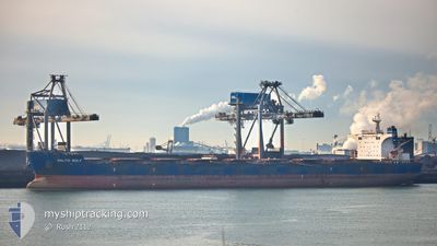
BALTIC WOLF
Bulk Carrier
Current Trip
| Time Travelled | --- |
|---|---|
| Remaining Time | 1 day |
| Distance Travelled | 8520.15 nm |
| Remaining Distance | 281.26 nm |
| AVG Speed | 10 Knots |
| MAX Speed | 13.7 Knots |
| AVG Wind | 7.5 knots |
| MAX Wind | 24 knots |
| MIN Temp | 14°C / 57.2°F |
| MAX Temp | 31.3°C / 88.34°F |
| Draught | 18.5 m |
| Position Received | 4 d ago |
Current Position
| Longitude | 104.31824° |
|---|---|
| Latitude | 1.28606° |
| Status | Under way using engine |
| Speed | 9 Knots |
| Course | 81.8° |
| Area | Singapore Strait |
| Station | T-AIS |
| Position Received | 4 d ago |
Info
Information
The current position of BALTIC WOLF is in Singapore Strait with coordinates 1.28606° / 104.31824° as reported on 2024-05-15 10:24 by AIS to our vessel tracker app. The vessel's current speed is 9 Knots and is heading at the port of ZHANJIANG. The estimated time of arrival as calculated by vessel tracking app is 2024-05-20 18:21 LT
The vessel BALTIC WOLF (IMO: 9492335, MMSI: 538003461) is a Bulk Carrier that was built in 2010 ( 14 years old ). It's sailing under the flag of [MH] Marshall Is.
In this page you can find informations about the vessels current position, last detected port calls, and current voyage information. If the vessels is not in coverage by AIS you will find the latest position.
The current position of BALTIC WOLF is detected by our AIS receivers and we are not responsible for the reliability of the data. The last position was recorded while the vessel was in Coverage by the Ais receivers of our vessel tracking app.
The current draught of BALTIC WOLF as reported by AIS is 18.5 meters
Weather
| Temperature | 29.5°C / 85.1°F |
|---|---|
| Wind Speed | 17 knots |
| Direction | 182° S |
| Pressure | 1003.7 hPa |
| Humidity | 82.7 % |
| Cloud Coverage | 100 % |
Featured Company
Last Port Calls
Most Visited Ports (Last year)
| Port | Arrivals | |
|---|---|---|
| 2 | ||
| 1 | ||
| 1 | ||
| 1 | ||
| 1 | ||
| 1 |
Last Trips
| Origin | Departure | Destination | Arrival | Distance |
|---|
Events
| Time | Event | Details | Position / Dest | Info |
|---|---|---|---|---|
| 2024-05-15 10:32 | Status Changed | Default Under way using engine |
1.29689 / 104.33409
MYTRB>CNZHA
|
Speed: 9 kn Course: 81.8° |
| 2024-05-15 10:24 | OUT of Coverage |
1.28606 / 104.31824
Singapore Strait
MYTRB>CNZHA
|
Speed: 9 kn Course: 81.8° |
|
| 2024-05-15 09:11 | Change Sea Area | Malaysian part of the Singapore Strait Indonesian part of the Singapore Strait |
1.26423 / 104.12925
Singapore Strait
MYTRB>CNZHA
|
Speed: 9.6 kn Course: 82.3° |
| 2024-05-15 07:14 | Change Sea Area | Indonesian part of the Singapore Strait Singaporean part of the Singapore Strait |
1.17919 / 103.82280
Singapore Strait
MYTRB>CNZHA
|
Speed: 10 kn Course: 69.1° |
| 2024-05-15 06:59 | Change Sea Area | Singaporean part of the Singapore Strait Indonesian part of the Singapore Strait |
1.15939 / 103.78581
Singapore Strait
MYTRB>CNZHA
|
Speed: 10 kn Course: 52.1° |
| 2024-05-15 05:21 | ETA Changed | 2024/05/21 01:00 2024/05/21 06:00 |
1.09391 / 103.57448
MYTRB>CNZHA
|
Speed: 8.9 kn Course: 126.1° |
| 2024-05-15 04:45 | Status Changed | Under way using engine Default |
1.14017 / 103.49210
MYTRB>CNZHA
|
Speed: 9.6 kn Course: 121° |
| 2024-05-15 04:40 | Status Changed | Default Under way using engine |
1.14603 / 103.48203
MYTRB>CNZHA
|
Speed: 9.8 kn Course: 116.5° |
| 2024-05-15 04:31 | Detected in Sea | Indonesian part of the Singapore Strait |
1.15755 / 103.46046
Singapore Strait
MYTRB>CNZHA
|
Speed: 9.8 kn Course: 116.2° |
| 2024-05-15 04:31 | Status Changed | Under way using engine Default |
1.15755 / 103.46046
MYTRB>CNZHA
|
Speed: 9.8 kn Course: 121° |