
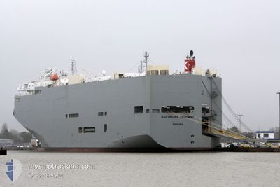
BALTIMORE HIGHWAY
Vehicles Carrier
Current Trip
| Time Travelled | 3 h, 57 mins |
|---|---|
| Remaining Time | 13 h, 47 mins |
| Distance Travelled | 68.24 nm |
| Remaining Distance | 243.24 nm |
| AVG Speed | 17.8 Knots |
| MAX Speed | 18.4 Knots |
| AVG Wind | 8.2 knots |
| MAX Wind | 10 knots |
| MIN Temp | 30.9°C / 87.62°F |
| MAX Temp | 34.1°C / 93.38°F |
| Draught | 8.4 m |
| Position Received | Now |
Current Position
| Longitude | 56.71028° |
|---|---|
| Latitude | 25.68327° |
| Status | Under way using engine |
| Speed | 17.7 Knots |
| Course | 11° |
| Area | Gulf of Oman |
| Station | T-AIS |
| Position Received | Now |
Info
Information
The current position of BALTIMORE HIGHWAY is in Gulf of Oman with coordinates 25.68327° / 56.71028° as reported on 2024-05-29 05:14 by AIS to our vessel tracker app. The vessel's current speed is 17.7 Knots and is heading at the port of ABU DHABI. The estimated time of arrival as calculated by vessel tracking app is 2024-05-29 19:02 LT
The vessel BALTIMORE HIGHWAY (IMO: 9510149, MMSI: 352517000) is a Vehicles Carrier that was built in 2009 ( 15 years old ). It's sailing under the flag of [PA] Panama.
In this page you can find informations about the vessels current position, last detected port calls, and current voyage information. If the vessels is not in coverage by AIS you will find the latest position.
The current position of BALTIMORE HIGHWAY is detected by our AIS receivers and we are not responsible for the reliability of the data. The last position was recorded while the vessel was in Coverage by the Ais receivers of our vessel tracking app.
The current draught of BALTIMORE HIGHWAY as reported by AIS is 8.4 meters
Weather
| Temperature | 31.3°C / 88.34°F |
|---|---|
| Wind Speed | 9 knots |
| Direction | 9° N |
| Pressure | 1001.5 hPa |
| Humidity | 76.5 % |
| Cloud Coverage | --- |
Featured Company
Last Port Calls
| Port | Arrival | Departure | Time In Port |
|---|---|---|---|
| 2024-05-28 14:45 | 2024-05-29 01:18 | 10 h | |
| 2024-05-19 01:17 | 2024-05-19 17:32 | 16 h | |
| 2024-05-13 08:28 | 2024-05-13 19:56 | 11 h | |
| 2024-05-06 20:59 | 2024-05-08 05:26 | 1 d | |
| 2024-04-16 01:47 | 2024-04-17 00:36 | 22 h | |
| 2024-04-14 01:59 | 2024-04-15 01:02 | 23 h | |
| 2024-03-29 20:36 | 2024-03-30 12:05 | 15 h | |
| 2024-03-26 19:13 | 2024-03-28 13:01 | 1 d | |
| 2024-03-20 02:39 | 2024-03-20 11:37 | 8 h | |
| 2024-03-10 07:31 | 2024-03-10 16:28 | 8 h |
Most Visited Ports (Last year)
| Port | Arrivals | |
|---|---|---|
| 5 | ||
| 4 | ||
| 3 | ||
| 3 | ||
| 3 | ||
| 2 |
Last Trips
| Origin | Departure | Destination | Arrival | Distance | |
|---|---|---|---|---|---|
| 2024-05-20 01:32 | 2024-05-28 18:45 | 3364.78 nm | |||
| 2024-05-14 03:56 | 2024-05-19 09:17 | 2223.63 nm | |||
| 2024-05-08 14:26 | 2024-05-13 16:28 | 911.81 nm | |||
| 2024-04-16 17:36 | 2024-05-07 05:59 | 5282.90 nm | |||
| 2024-04-14 18:02 | 2024-04-15 18:47 | 65.98 nm | |||
| 2024-03-30 21:05 | 2024-04-13 18:59 | 5210.83 nm | |||
| 2024-03-28 22:01 | 2024-03-30 05:36 | 407.04 nm | |||
| 2024-03-20 19:37 | 2024-03-27 04:13 | 2595.24 nm | |||
| 2024-03-10 19:28 | 2024-03-20 10:39 | 4006.23 nm | |||
| 2024-03-09 18:21 | 2024-03-10 10:31 | 190.90 nm |
Events
| Time | Event | Details | Position / Dest | Info |
|---|---|---|---|---|
| 2024-05-29 03:04 | Change Sea Area | United Arab Emirates part of the Gulf of Oman Omani part of the Gulf of Oman |
25.03775 / 56.65372
Gulf of Oman
AE AUH
|
Speed: 18.3 kn Course: 4° |
| 2024-05-29 02:15 | Draught Changed | 8.4 8.9 |
24.78558 / 56.63952
AE AUH
|
Speed: 18.1 kn Course: 1° |
| 2024-05-29 02:15 | Destination Changed | AE AUH OM SOH |
24.78558 / 56.63952
AE AUH
|
Speed: 18.1 kn Course: 1° |
| 2024-05-29 02:15 | ETA Changed | 2024/05/29 18:00 2024/05/28 00:01 |
24.78558 / 56.63952
AE AUH
|
Speed: 18.1 kn Course: 1° |
| 2024-05-29 02:13 | Status Changed | Under way using engine Default |
24.77750 / 56.63928
OM SOH
|
Speed: 18 kn Course: 2° |
| 2024-05-29 01:34 | Status Changed | Default Under way using engine |
24.59027 / 56.62835
OM SOH
|
Speed: 13.6 kn Course: 0° |
| 2024-05-29 01:28 | Status Changed | Under way using engine Default |
24.56425 / 56.62870
OM SOH
|
Speed: 12.1 kn Course: 359° |
| 2024-05-29 01:22 | IN Coverage |
24.56425 / 56.62870
Gulf of Oman
|
Speed: 13.6 kn Course: 0° |
|
| 2024-05-29 01:18 | PORT DEPARTURE |
|
24.53143 / 56.62867
OM SOH
|
Speed: 8.7 kn Course: 1° |
| 2024-05-29 01:03 | START Moving |
24.50090 / 56.62670
[OM] SOHAR
|
Speed: 3.8 kn Course: 42° |