
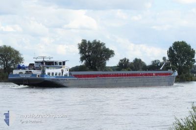
BATTENOORD
Cargo
Current Trip
| Trip Time | 23 h, 44 mins |
|---|---|
| Trip Distance | 70.91 nm |
| AVG Speed | 8 Knots |
| MAX Speed | 10.3 Knots |
| Draught | 3 m |
| AVG Wind | 8.1 knots |
| MAX Wind | 14 knots |
| MIN Temp | 12.1°C / 53.78°F |
| MAX Temp | 19.7°C / 67.46°F |
| Position Received | 1 m ago |
Current Position
| Longitude | 4.86454° |
|---|---|
| Latitude | 52.40492° |
| Status | Under way using engine |
| Speed | |
| Course | 35° |
| Area | North Sea |
| Station | T-AIS |
| Position Received | 1 m ago |
Info
Information
The current position of BATTENOORD is in North Sea with coordinates 52.40492° / 4.86454° as reported on 2024-06-01 20:43 by AIS to our vessel tracker app. The vessel's current speed is 0 Knots and is currently inside the port of AMSTERDAM.
The vessel BATTENOORD (MMSI: 244700075) is a Cargo It's sailing under the flag of [NL] Netherlands.
In this page you can find informations about the vessels current position, last detected port calls, and current voyage information. If the vessels is not in coverage by AIS you will find the latest position.
The current position of BATTENOORD is detected by our AIS receivers and we are not responsible for the reliability of the data. The last position was recorded while the vessel was in Coverage by the Ais receivers of our vessel tracking app.
The current draught of BATTENOORD as reported by AIS is 3 meters
Weather
| Temperature | 13°C / 55.4°F |
|---|---|
| Wind Speed | 13 knots |
| Direction | 360° N |
| Pressure | 1021.4 hPa |
| Humidity | 84.2 % |
| Cloud Coverage | 86 % |
Featured Company
Last Port Calls
| Port | Arrival | Departure | Time In Port |
|---|---|---|---|
| 2024-05-31 19:57 | |||
| 2024-05-30 19:41 | 2024-05-30 20:13 | 32 m | |
| 2024-05-29 19:21 | 2024-05-30 11:00 | 15 h | |
| 2024-05-29 17:48 | 2024-05-29 18:30 | 42 m | |
| 2024-05-27 16:54 | 2024-05-27 17:14 | 19 m | |
| 2024-05-25 07:17 | 2024-05-27 15:04 | 2 d | |
| 2024-05-25 06:10 | 2024-05-25 06:48 | 38 m | |
| 2024-05-24 15:55 | 2024-05-24 16:15 | 19 m | |
| 2024-05-23 20:24 | 2024-05-24 06:04 | 9 h | |
| 2024-05-18 09:23 | 2024-05-23 12:40 | 5 d |
Last Trips
| Origin | Departure | Destination | Arrival | Distance | |
|---|---|---|---|---|---|
| 2024-05-30 22:13 | 2024-05-31 21:57 | 70.91 nm | |||
| 2024-05-30 13:00 | 2024-05-30 21:41 | 72.59 nm | |||
| 2024-05-29 20:30 | 2024-05-29 21:21 | 4.70 nm | |||
| 2024-05-27 19:14 | 2024-05-29 19:48 | 111.34 nm | |||
| 2024-05-27 17:04 | 2024-05-27 18:54 | 16.48 nm | |||
| 2024-05-25 08:48 | 2024-05-25 09:17 | 3.61 nm | |||
| 2024-05-24 18:15 | 2024-05-25 08:10 | 39.62 nm | |||
| 2024-05-24 08:04 | 2024-05-24 17:55 | 30.57 nm | |||
| 2024-05-23 14:40 | 2024-05-23 22:24 | 52.34 nm | |||
| 2024-05-18 11:15 | 2024-05-18 11:23 | 0.58 nm |
Events
| Time | Event | Details | Position / Dest | Info |
|---|---|---|---|---|
| 2024-05-31 20:15 | STOP Moving |
52.40492 / 4.86454
[NL] AMSTERDAM
|
Speed: 0.1 kn Course: 36° |
|
| 2024-05-31 19:57 | PORT ARRIVAL |
|
52.41103 / 4.86798
[NL] AMSTERDAM
|
Speed: 4.8 kn Course: 266° |
| 2024-05-31 19:29 | ETA Changed | 2024/09/28 16:34 |
52.38199 / 4.92400
THATS THE QUESTION
|
Speed: 6.7 kn Course: 259° |
| 2024-05-31 18:31 | IN Coverage |
52.30973 / 5.02036
North Sea
|
Speed: 6.5 kn Course: 353° |
|
| 2024-05-31 17:20 | OUT of Coverage |
52.13373 / 5.03919
North Sea
|
Speed: 5.9 kn Course: 320.5° |
|
| 2024-05-31 16:06 | IN Coverage |
52.07453 / 5.08531
North Sea
|
Speed: 6.4 kn Course: 328.9° |
|
| 2024-05-31 12:14 | OUT of Coverage |
51.88966 / 5.50613
North Sea
|
Speed: 10.1 kn Course: 261.7° |
|
| 2024-05-31 10:51 | START Moving | 1.19 nm, East of NIJMEGEN |
51.85187 / 5.85487
THATS THE QUESTION
|
Speed: 7.2 kn Course: 297.6° |
| 2024-05-31 10:39 | STOP Moving | 1.27 nm, East of NIJMEGEN |
51.85079 / 5.85740
THATS THE QUESTION
|
Speed: 0.2 kn Course: 291° |
| 2024-05-31 09:12 | START Moving | 0.87 nm, East of TOLKAMER |
51.84881 / 6.12727
THATS THE QUESTION
|
Speed: 5.7 kn Course: 267.4° |