
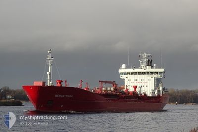
BERGSTRAUM
Oil/Chemical Tanker
Current Trip
| Time Travelled | 1 day |
|---|---|
| Remaining Time | --- |
| Distance Travelled | 324.52 nm |
| Remaining Distance | --- |
| AVG Speed | 12.6 Knots |
| MAX Speed | 15.5 Knots |
| AVG Wind | 12.1 knots |
| MAX Wind | 19.2 knots |
| MIN Temp | 12.9°C / 55.22°F |
| MAX Temp | 18.7°C / 65.66°F |
| Draught | 7.3 m |
| Position Received | Now |
Current Position
| Longitude | 9.16763° |
|---|---|
| Latitude | 53.90587° |
| Status | Under way using engine |
| Speed | 6.6 Knots |
| Course | 46.9° |
| Area | North Sea |
| Station | T-AIS |
| Position Received | Now |
Info
Information
The current position of BERGSTRAUM is in North Sea with coordinates 53.90587° / 9.16763° as reported on 2024-05-23 14:26 by AIS to our vessel tracker app. The vessel's current speed is 6.6 Knots
The vessel BERGSTRAUM (IMO: 9108740, MMSI: 259319000) is a Oil/Chemical Tanker that was built in 1996 ( 28 years old ). It's sailing under the flag of [NO] Norway.
In this page you can find informations about the vessels current position, last detected port calls, and current voyage information. If the vessels is not in coverage by AIS you will find the latest position.
The current position of BERGSTRAUM is detected by our AIS receivers and we are not responsible for the reliability of the data. The last position was recorded while the vessel was in Coverage by the Ais receivers of our vessel tracking app.
The current draught of BERGSTRAUM as reported by AIS is 7.3 meters
Weather
| Temperature | 18.5°C / 65.3°F |
|---|---|
| Wind Speed | 7 knots |
| Direction | 286° WNW |
| Pressure | 1013.9 hPa |
| Humidity | 69.8 % |
| Cloud Coverage | 10 % |
Featured Company
Last Port Calls
| Port | Arrival | Departure | Time In Port |
|---|---|---|---|
| 2024-05-21 00:21 | 2024-05-22 12:59 | 1 d | |
| 2024-05-14 03:08 | 2024-05-14 03:13 | 5 m | |
| 2024-05-10 17:51 | 2024-05-12 11:24 | 1 d | |
| 2024-05-07 18:23 | 2024-05-07 19:40 | 1 h | |
| 2024-05-01 01:10 | 2024-05-01 16:52 | 15 h | |
| 2024-04-29 12:32 | 2024-04-30 05:20 | 16 h | |
| 2024-04-25 18:47 | 2024-04-26 10:02 | 15 h | |
| 2024-04-22 14:27 | 2024-04-23 17:18 | 1 d | |
| 2024-04-18 11:04 | 2024-04-18 11:08 | 4 m | |
| 2024-04-10 19:47 | 2024-04-16 17:02 | 5 d |
Most Visited Ports (Last year)
| Port | Arrivals | |
|---|---|---|
| 8 | ||
| 7 | ||
| 6 | ||
| 5 | ||
| 4 | ||
| 4 |
Last Trips
| Origin | Departure | Destination | Arrival | Distance | |
|---|---|---|---|---|---|
| 2024-05-14 05:13 | 2024-05-21 02:21 | 800.90 nm | |||
| 2024-05-12 13:24 | 2024-05-14 05:08 | 431.16 nm | |||
| 2024-05-07 21:40 | 2024-05-10 19:51 | 269.64 nm | |||
| 2024-05-01 18:52 | 2024-05-07 20:23 | 1237.31 nm | |||
| 2024-04-30 07:20 | 2024-05-01 03:10 | 236.87 nm | |||
| 2024-04-26 12:02 | 2024-04-29 14:32 | 684.41 nm | |||
| 2024-04-23 19:18 | 2024-04-25 20:47 | 622.30 nm | |||
| 2024-04-18 13:08 | 2024-04-22 16:27 | 626.51 nm | |||
| 2024-04-16 19:02 | 2024-04-18 13:04 | 430.96 nm | |||
| 2024-04-07 23:31 | 2024-04-10 21:47 | 566.14 nm |
Events
| Time | Event | Details | Position / Dest | Info |
|---|---|---|---|---|
| 2024-05-23 14:16 | START Moving | 0.66 nm, South West of BRUNSBUETTEL |
53.89485 / 9.14758
NLRTM>PLSZZ VIANOK
|
Speed: 3.1 kn Course: 49° |
| 2024-05-23 13:20 | STOP Moving | 0.84 nm, South West of BRUNSBUETTEL |
53.89277 / 9.14367
NLRTM>PLSZZ VIANOK
|
Speed: 0.3 kn Course: 44° |
| 2024-05-23 10:48 | Status Changed | Under way using engine Default |
53.97428 / 8.46830
NLRTM>PLSZZ VIANOK
|
Speed: 14.3 kn Course: 99° |
| 2024-05-23 10:41 | Status Changed | Default Under way using engine |
53.97982 / 8.41998
NLRTM>PLSZZ VIANOK
|
Speed: 14.5 kn Course: 99° |
| 2024-05-23 10:34 | Status Changed | Under way using engine Default |
53.98522 / 8.37370
NLRTM>PLSZZ VIANOK
|
Speed: 14.4 kn Course: 100° |
| 2024-05-23 09:52 | Status Changed | Default Under way using engine |
53.99233 / 8.11900
NLRTM>PLSZZ VIANOK
|
Speed: 13.1 kn Course: 106.8° |
| 2024-05-23 09:21 | Status Changed | Under way using engine Default |
54.04063 / 7.94345
NLRTM>PLSZZ VIANOK
|
Speed: 14.2 kn Course: 119° |
| 2024-05-23 09:15 | Status Changed | Default Under way using engine |
54.05129 / 7.91118
NLRTM>PLSZZ VIANOK
|
Speed: 14.2 kn Course: 119° |
| 2024-05-23 09:14 | Status Changed | Under way using engine Default |
54.05493 / 7.90005
NLRTM>PLSZZ VIANOK
|
Speed: 14.5 kn Course: 121° |
| 2024-05-23 08:06 | OUT of Coverage |
54.15453 / 7.47133
North Sea
NLRTM>PLSZZ VIANOK
|
Speed: 14.9 kn Course: 89° |