
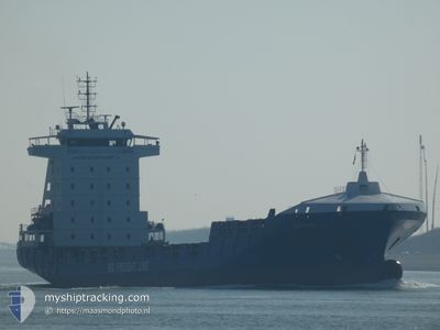
BG RUBY
Container Ship
Current Trip
| Trip Time | 1 day |
|---|---|
| Trip Distance | 654.95 nm |
| AVG Speed | 13.9 Knots |
| MAX Speed | 18.7 Knots |
| Draught | 6.6 m |
| AVG Wind | 11.3 knots |
| MAX Wind | 23.8 knots |
| MIN Temp | 12.9°C / 55.22°F |
| MAX Temp | 15.8°C / 60.44°F |
| Position Received | 2 m ago |
Current Position
| Longitude | 4.41338° |
|---|---|
| Latitude | 51.87815° |
| Status | Moored |
| Speed | |
| Course | 288° |
| Area | North Sea |
| Station | T-AIS |
| Position Received | 2 m ago |
Info
Information
The current position of BG RUBY is in North Sea with coordinates 51.87815° / 4.41338° as reported on 2024-05-30 18:54 by AIS to our vessel tracker app. The vessel's current speed is 0 Knots and is currently inside the port of ROTTERDAM WAALHAVEN.
The vessel BG RUBY (IMO: 9436202, MMSI: 255771000) is a Container Ship that was built in 2009 ( 15 years old ). It's sailing under the flag of [PT] Portugal.
In this page you can find informations about the vessels current position, last detected port calls, and current voyage information. If the vessels is not in coverage by AIS you will find the latest position.
The current position of BG RUBY is detected by our AIS receivers and we are not responsible for the reliability of the data. The last position was recorded while the vessel was in Coverage by the Ais receivers of our vessel tracking app.
The current draught of BG RUBY as reported by AIS is 6.6 meters
Weather
| Temperature | 14°C / 57.2°F |
|---|---|
| Wind Speed | 8 knots |
| Direction | 296° WNW |
| Pressure | 1007.8 hPa |
| Humidity | 78.1 % |
| Cloud Coverage | 94 % |
Featured Company
Last Port Calls
| Port | Arrival | Departure | Time In Port |
|---|---|---|---|
| 2024-05-30 07:08 | |||
| 2024-05-27 01:31 | 2024-05-28 11:21 | 1 d | |
| 2024-05-23 20:33 | 2024-05-25 05:31 | 1 d | |
| 2024-05-23 07:27 | 2024-05-23 17:57 | 10 h | |
| 2024-05-20 01:37 | 2024-05-21 02:57 | 1 d | |
| 2024-05-16 20:52 | 2024-05-18 06:26 | 1 d | |
| 2024-05-16 07:10 | 2024-05-16 17:58 | 10 h | |
| 2024-05-13 01:32 | 2024-05-14 02:39 | 1 d | |
| 2024-05-09 19:40 | 2024-05-11 04:36 | 1 d | |
| 2024-05-09 09:37 | 2024-05-09 16:47 | 7 h |
Most Visited Ports (Last year)
| Port | Arrivals | |
|---|---|---|
| 56 | ||
| 37 | ||
| 26 | ||
| 26 | ||
| 10 | ||
| 1 |
Last Trips
| Origin | Departure | Destination | Arrival | Distance | |
|---|---|---|---|---|---|
| 2024-05-28 12:21 | 2024-05-30 09:08 | 654.95 nm | |||
| 2024-05-25 07:31 | 2024-05-27 02:31 | 642.21 nm | |||
| 2024-05-23 19:57 | 2024-05-23 22:33 | 23.56 nm | |||
| 2024-05-21 03:57 | 2024-05-23 09:27 | 674.98 nm | |||
| 2024-05-18 08:26 | 2024-05-20 02:37 | 640.75 nm | |||
| 2024-05-16 19:58 | 2024-05-16 22:52 | 23.59 nm | |||
| 2024-05-14 03:39 | 2024-05-16 09:10 | 674.97 nm | |||
| 2024-05-11 06:36 | 2024-05-13 02:32 | 640.74 nm | |||
| 2024-05-09 18:47 | 2024-05-09 21:40 | 23.70 nm | |||
| 2024-05-07 12:29 | 2024-05-09 11:37 | 674.10 nm |
Events
| Time | Event | Details | Position / Dest | Info |
|---|---|---|---|---|
| 2024-05-30 07:09 | Status Changed | Moored Under way using engine |
51.87819 / 4.41315
[NL] ROTTERDAM WAALHAVEN
|
Speed: 0.3 kn Course: 291° |
| 2024-05-30 07:08 | STOP Moving |
51.87826 / 4.41310
[NL] ROTTERDAM WAALHAVEN
|
Speed: 0.3 kn Course: 292° |
|
| 2024-05-30 07:08 | PORT ARRIVAL |
|
51.87832 / 4.41301
[NL] ROTTERDAM WAALHAVEN
|
Speed: 0.6 kn Course: 294° |
| 2024-05-30 01:29 | Change Sea Area | Dutch part of the North Sea Belgian part of the North Sea |
51.76902 / 2.71944
North Sea
IEDUB-NLRTM
|
Speed: 12.7 kn Course: 63.5° |
| 2024-05-29 23:38 | Change Sea Area | Belgian part of the North Sea French part of the North Sea |
51.50046 / 2.27887
North Sea
IEDUB-NLRTM
|
Speed: 12.4 kn Course: 42° |
| 2024-05-29 20:34 | Detected in Sea | French part of the North Sea |
51.00285 / 1.61074
North Sea
IEDUB-NLRTM
|
Speed: 14.2 kn Course: 39.6° |
| 2024-05-29 19:09 | ETA Changed | 2024/05/30 07:00 2024/05/30 07:15 |
50.68713 / 1.36702
IEDUB-NLRTM
|
Speed: 15.1 kn Course: 44.1° |
| 2024-05-29 17:48 | Change Sea Area | French part of the English Channel United Kingdom part of the English Channel |
50.48548 / .91406
English Channel
IEDUB-NLRTM
|
Speed: 15.7 kn Course: 74° |
| 2024-05-29 12:11 | Status Changed | Under way using engine Default |
50.33902 / -1.52037
IEDUB-NLRTM
|
Speed: 18.7 kn Course: 86° |
| 2024-05-29 11:48 | Status Changed | Default Under way using engine |
50.33068 / -1.70734
IEDUB-NLRTM
|
Speed: 18.5 kn Course: 86.1° |