
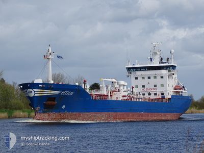
BITHAV
Oil/Chemical Tanker
Current Trip
| Trip Time | 2 days |
|---|---|
| Trip Distance | 599.98 nm |
| AVG Speed | 10.6 Knots |
| MAX Speed | 15.3 Knots |
| Draught | 6.4 m |
| AVG Wind | 9.2 knots |
| MAX Wind | 24 knots |
| MIN Temp | 11.9°C / 53.42°F |
| MAX Temp | 26.6°C / 79.88°F |
| Position Received | 1 m ago |
Current Position
| Longitude | -9.04824° |
|---|---|
| Latitude | 53.26947° |
| Status | Moored |
| Speed | |
| Course | 311° |
| Area | North Atlantic Ocean |
| Station | T-AIS |
| Position Received | 1 m ago |
Info
Information
The current position of BITHAV is in North Atlantic Ocean with coordinates 53.26947° / -9.04824° as reported on 2024-06-29 19:23 by AIS to our vessel tracker app. The vessel's current speed is 0 Knots and is currently inside the port of GALWAY.
The vessel BITHAV (IMO: 9211535, MMSI: 246697000) is a Oil/Chemical Tanker that was built in 2000 ( 24 years old ). It's sailing under the flag of [NL] Netherlands.
In this page you can find informations about the vessels current position, last detected port calls, and current voyage information. If the vessels is not in coverage by AIS you will find the latest position.
The current position of BITHAV is detected by our AIS receivers and we are not responsible for the reliability of the data. The last position was recorded while the vessel was in Coverage by the Ais receivers of our vessel tracking app.
The current draught of BITHAV as reported by AIS is 6.4 meters
Weather
| Temperature | 14.6°C / 58.28°F |
|---|---|
| Wind Speed | 10 knots |
| Direction | 353° N |
| Pressure | 1015.8 hPa |
| Humidity | 70.7 % |
| Cloud Coverage | 1 % |
Featured Company
Last Port Calls
| Port | Arrival | Departure | Time In Port |
|---|---|---|---|
| 2024-06-28 21:55 | |||
| 2024-06-25 02:02 | 2024-06-26 15:26 | 1 d | |
| 2024-06-15 19:31 | 2024-06-17 06:18 | 1 d | |
| 2024-06-15 07:38 | 2024-06-15 15:23 | 7 h | |
| 2024-06-12 08:36 | 2024-06-13 20:57 | 1 d | |
| 2024-06-09 02:09 | 2024-06-10 06:50 | 1 d | |
| 2024-06-02 08:08 | 2024-06-03 10:23 | 1 d | |
| 2024-05-31 05:34 | 2024-06-01 18:23 | 1 d | |
| 2024-05-30 20:34 | 2024-05-31 02:54 | 6 h | |
| 2024-05-29 18:25 | 2024-05-30 12:49 | 18 h |
Most Visited Ports (Last year)
| Port | Arrivals | |
|---|---|---|
| 17 | ||
| 10 | ||
| 9 | ||
| 8 | ||
| 6 | ||
| 5 |
Last Trips
| Origin | Departure | Destination | Arrival | Distance | |
|---|---|---|---|---|---|
| 2024-06-26 17:26 | 2024-06-28 22:55 | 599.98 nm | |||
| 2024-06-17 07:18 | 2024-06-25 04:02 | 1097.93 nm | |||
| 2024-06-13 21:57 | 2024-06-15 20:31 | 478.62 nm | |||
| 2024-06-13 21:57 | 2024-06-15 08:38 | 452.57 nm | |||
| 2024-06-10 08:50 | 2024-06-12 09:36 | 602.56 nm | |||
| 2024-06-03 11:23 | 2024-06-09 04:09 | 476.66 nm | |||
| 2024-06-01 19:23 | 2024-06-02 09:08 | 125.12 nm | |||
| 2024-05-30 13:49 | 2024-05-31 06:34 | 128.33 nm | |||
| 2024-05-30 13:49 | 2024-05-30 21:34 | 102.24 nm | |||
| 2024-05-27 17:36 | 2024-05-29 19:25 | 643.64 nm |
Events
| Time | Event | Details | Position / Dest | Info |
|---|---|---|---|---|
| 2024-06-28 22:32 | Status Changed | Moored Under way using engine |
53.26947 / -9.04825
[IE] GALWAY
|
Speed: Course: 312° |
| 2024-06-28 22:04 | STOP Moving |
53.26900 / -9.04773
[IE] GALWAY
|
Speed: 0.3 kn Course: 314° |
|
| 2024-06-28 21:55 | PORT ARRIVAL |
|
53.26722 / -9.04530
[IE] GALWAY
|
Speed: 2.9 kn Course: 315° |
| 2024-06-28 21:29 | START Moving | 1.6 nm, South of GALWAY |
53.24325 / -9.06287
FRPJE > IEGWY
|
Speed: 3.2 kn Course: 69° |
| 2024-06-28 20:51 | Status Changed | Under way using engine At anchor |
53.24202 / -9.07737
FRPJE > IEGWY
|
Speed: 0.9 kn Course: 224° |
| 2024-06-28 16:40 | STOP Moving | 1.75 nm, South West of GALWAY |
53.24350 / -9.07487
FRPJE > IEGWY
|
Speed: 0.3 kn Course: 215° |
| 2024-06-28 16:35 | Status Changed | At anchor Under way using engine |
53.24281 / -9.07604
FRPJE > IEGWY
|
Speed: 1.2 kn Course: 210° |
| 2024-06-28 15:46 | Status Changed | Under way using engine Default |
53.17804 / -9.28317
FRPJE > IEGWY
|
Speed: 13.2 kn Course: 36° |
| 2024-06-28 15:46 | IN Coverage |
53.17943 / -9.27861
North Atlantic Ocean
FRPJE > IEGWY
|
Speed: 13.4 kn Course: 64.4° |
|
| 2024-06-28 05:40 | OUT of Coverage |
51.47718 / -10.22693
North Atlantic Ocean
FRPJE > IEGWY
|
Speed: 11.9 kn Course: 304.6° |