
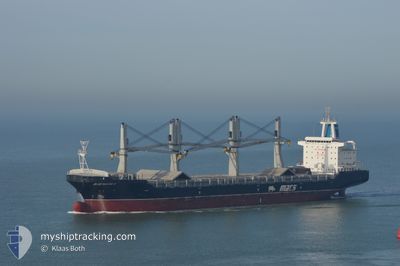
BLUE MASTER II
General Cargo
Current Trip
| Time Travelled | 13 h, 47 mins |
|---|---|
| Remaining Time | 6 h, 59 mins |
| Distance Travelled | 203.52 nm |
| Remaining Distance | 112.70 nm |
| AVG Speed | 14 Knots |
| MAX Speed | 16.2 Knots |
| AVG Wind | 14.4 knots |
| MAX Wind | 20 knots |
| MIN Temp | 15.6°C / 60.08°F |
| MAX Temp | 17.2°C / 62.96°F |
| Draught | 8.1 m |
| Position Received | 1 m ago |
Current Position
| Longitude | 7.18983° |
|---|---|
| Latitude | 53.86911° |
| Status | Under way using engine |
| Speed | 13.7 Knots |
| Course | 77.4° |
| Area | North Sea |
| Station | T-AIS |
| Position Received | 1 m ago |
Info
Information
The current position of BLUE MASTER II is in North Sea with coordinates 53.86911° / 7.18983° as reported on 2024-06-28 10:12 by AIS to our vessel tracker app. The vessel's current speed is 13.7 Knots and is heading at the port of HAMBURG. The estimated time of arrival as calculated by vessel tracking app is 2024-06-28 17:12 LT
The vessel BLUE MASTER II (IMO: 9465411, MMSI: 538090451) is a General Cargo that was built in 2013 ( 11 years old ). It's sailing under the flag of [MH] Marshall Is.
In this page you can find informations about the vessels current position, last detected port calls, and current voyage information. If the vessels is not in coverage by AIS you will find the latest position.
The current position of BLUE MASTER II is detected by our AIS receivers and we are not responsible for the reliability of the data. The last position was recorded while the vessel was in Coverage by the Ais receivers of our vessel tracking app.
The current draught of BLUE MASTER II as reported by AIS is 8.1 meters
Weather
| Temperature | 16.1°C / 60.98°F |
|---|---|
| Wind Speed | 19 knots |
| Direction | 256° WSW |
| Pressure | 1012.9 hPa |
| Humidity | 79.1 % |
| Cloud Coverage | --- |
Featured Company
Last Port Calls
| Port | Arrival | Departure | Time In Port |
|---|---|---|---|
| 2024-06-25 19:51 | 2024-06-27 20:26 | 2 d | |
| 2024-06-25 12:21 | 2024-06-25 17:25 | 5 h | |
| 2024-06-22 03:30 | 2024-06-22 19:27 | 15 h | |
| 2024-06-03 08:24 | 2024-06-06 22:14 | 3 d | |
| 2024-05-30 22:01 | 2024-05-31 18:31 | 20 h | |
| 2024-05-16 07:47 | 2024-05-24 09:46 | 8 d | |
| 2024-05-11 07:41 | 2024-05-13 07:55 | 2 d | |
| 2024-05-01 06:21 | 2024-05-03 09:37 | 2 d | |
| 2024-04-26 04:15 | 2024-04-28 19:14 | 2 d | |
| 2024-04-10 13:17 | 2024-04-11 06:12 | 16 h |
Last Trips
| Origin | Departure | Destination | Arrival | Distance | |
|---|---|---|---|---|---|
| 2024-06-25 19:25 | 2024-06-25 21:51 | 20.85 nm | |||
| 2024-06-22 21:27 | 2024-06-25 14:21 | 899.54 nm | |||
| 2024-06-07 00:14 | 2024-06-22 05:30 | 4736.74 nm | |||
| 2024-05-31 20:31 | 2024-06-03 10:24 | 721.32 nm | |||
| 2024-05-24 11:46 | 2024-05-31 00:01 | 1081.20 nm | |||
| 2024-05-13 09:55 | 2024-05-16 09:47 | 347.15 nm | |||
| 2024-05-03 11:37 | 2024-05-11 09:41 | 1169.23 nm | |||
| 2024-04-28 21:14 | 2024-05-01 08:21 | 721.68 nm | |||
| 2024-04-11 07:12 | 2024-04-26 06:15 | 4709.16 nm | |||
| 2024-04-05 14:32 | 2024-04-10 14:17 | 983.47 nm |
Events
| Time | Event | Details | Position / Dest | Info |
|---|---|---|---|---|
| 2024-06-28 08:56 | Change Sea Area | German part of the North Sea Dutch part of the North Sea |
53.79286 / 6.66077
North Sea
HAMBURG
|
Speed: 15.4 kn Course: 72.4° |
| 2024-06-28 08:54 | Status Changed | Under way using engine Default |
53.79057 / 6.64835
HAMBURG
|
Speed: 15.5 kn Course: 73° |
| 2024-06-28 08:38 | IN Coverage |
53.79286 / 6.66077
North Sea
HAMBURG
|
Speed: 15.4 kn Course: 72.4° |
|
| 2024-06-28 07:25 | Status Changed | Default Under way using engine |
53.68769 / 6.04387
HAMBURG
|
Speed: 15.1 kn Course: 69.7° |
| 2024-06-28 07:20 | OUT of Coverage |
53.67970 / 6.00809
North Sea
HAMBURG
|
Speed: 15.1 kn Course: 69.7° |
|
| 2024-06-28 07:12 | Status Changed | Under way using engine Default |
53.66843 / 5.95665
HAMBURG
|
Speed: 15 kn Course: 69° |
| 2024-06-28 07:09 | Status Changed | Default Under way using engine |
53.66362 / 5.93412
HAMBURG
|
Speed: 15 kn Course: 69.6° |
| 2024-06-27 20:26 | PORT DEPARTURE |
|
51.89541 / 4.39672
HAMBURG
|
Speed: 8.4 kn Course: 304° |
| 2024-06-27 20:16 | START Moving |
51.88152 / 4.41253
[NL] ROTTERDAM WAALHAVEN
|
Speed: 3.5 kn Course: 286° |
|
| 2024-06-27 20:12 | Status Changed | Under way using engine Moored |
51.88134 / 4.41595
[NL] ROTTERDAM WAALHAVEN
|
Speed: 0.3 kn Course: 284° |